
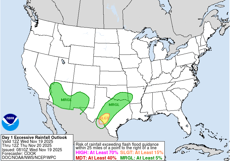
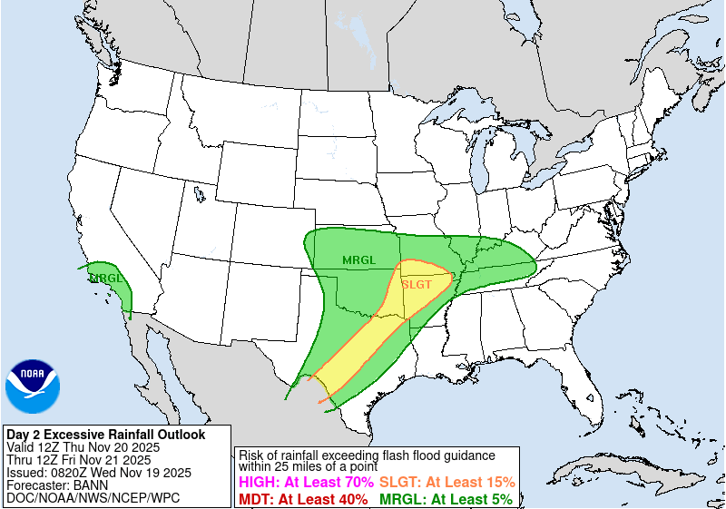
Slight Risk of Excessive Rainfall in the Southwest, Flood Watches in effect for parts of Texas
Flood Watches are in effect for parts of southern and central Texas through Thursday, November 20, 2025, as a low-pressure system moves east across the southwestern United States. The Weather Prediction Center has placed portions of the Southwest under a Slight Risk of Excessive Rainfall, with some areas expected to receive up to 150 mm (6 inches) of rain.

Satellite image of Texas, USA as of 21:20 UTC on November 18, 2025. Credit: NOAA/GOES-19, Zoom Earth, The Watchers
The Weather Prediction Center (WPC) forecast a Slight Risk (level 2 of 4) of excessive rainfall over parts of the Southwest on Wednesday and southern Texas on Thursday, November 20.
A developing low-pressure system is currently moving eastward from the desert Southwest into the Southern Plains.
The system is forecast to bring heavy rain and thunderstorms, spreading from the Southern Rockies and High Plains into central and southern Texas through Thursday night. There is a risk of localized flash flooding across the region, particularly in urban areas, roads, small streams, and burn scars.
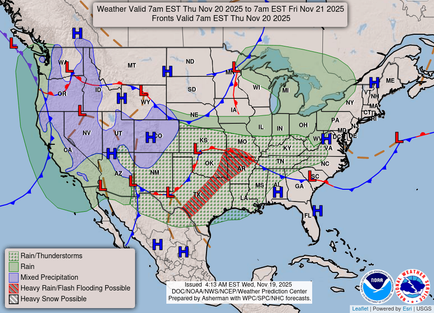
Flood Watches have been issued for several regions of Texas, including parts of the Hill Country, Edwards Plateau, and the I-35 corridor.
The National Weather Service (NWS) San Angelo office issued a Flood Watch valid from Wednesday evening, November 19 through late Thursday night for Brown, Kimble, Mason, McCulloch, Menard, San Saba, and Sutton counties.
Rainfall totals are expected to reach 50–100 mm (2–4 inches), with isolated amounts exceeding 150 mm (6 inches), mainly southeast of a Brownwood-Brady-Menard-Sonora line. The agency warns of possible flooding of rivers, creeks, streams, and other low-lying areas.
The NWS Austin/San Antonio office issued a Flood Watch from late Wednesday night through late Thursday night covering Val Verde, Edwards, Real, Kerr, Bandera, Gillespie, Kendall, Blanco, Hays, Travis, Medina, Bexar, Comal, Burnet, Llano, Kinney, Uvalde, and Williamson counties.
Rainfall totals of 25–75 mm (1–3 inches) are forecast, with isolated totals of up to 150 mm (6 inches). The heaviest rainfall is forecast along and east of the Edwards Plateau into the I-35 corridor, including the Austin–San Antonio region. Flash flooding may occur in poor drainage areas and along small streams.
The system will also produce rain and snow across parts of the Central and Southern Rockies, with light snow over the Sierra Nevada and southern Utah Mountains.
A secondary front approaching the Pacific Coast is expected to bring light rain to Northern and Central California on Wednesday, expanding into Southern California on Thursday as the low moves toward northwestern Mexico.
References:
1 Short Range Forecast Discussion – NWS – November 19, 2025

I am an Assistant Editor and Severe Weather & Science Journalist at The Watchers, specializing in real-time severe weather coverage, geophysical event reporting, and research-driven scientific analysis. You can reach me at rishav(at)watchers(.)news.
Commenting rules and guidelines
We value the thoughts and opinions of our readers and welcome healthy discussions on our website. In order to maintain a respectful and positive community, we ask that all commenters follow these rules.