
Blizzard Warning in effect for Kuskokwim Delta and Nunivak, Winter Storm Warning for the Bering Strait and Seward Peninsula, western Alaska
A Blizzard Warning is in effect for the Kuskokwim Delta coast and Nunivak Island, Alaska, until 05:00 AKST Monday, November 17, 2025, with visibility down to 400 m (1/4 mile), additional snow of 5–10 cm (2–4 inches), and wind gusts up to 80 km/h (50 mph) expected. In addition, a Winter Storm Warning is in effect for the Bering Strait Coast and the southern and interior Seward Peninsula from early Monday through Wednesday afternoon, November 19, including Nome, Shishmaref, Golovin and White Mountain, with 20–30 cm (8–12 inches) of snow, blowing snow and gusts up to 65 km/h (40 mph).

Satellite image acquired at 22:10 UTC on November 16, 2025. Credit: NOAA/GOES-West, RAMMB/CIRA, The Watchers
A Blizzard Warning is in effect for the Kuskokwim Delta coast and Nunivak Island until 05:00 AKST Monday, November 17. Forecast hazards include visibility down to 400 m (1/4 mile), an additional 5–10 cm (2–4 inches) of snow, and wind gusts up to 80 km/h (50 mph). A Coastal Flood Advisory follows from 03:00 to 12:00 AKST for vulnerable shorelines along the Delta.
Communities within the Blizzard Warning area include Mekoryuk on Nunivak Island and coastal villages across the Kuskokwim Delta, such as Kipnuk, Toksook Bay, Nightmute, and Chefornak.
Current conditions include an ongoing blizzard on Nelson Island and Nunivak Island, with blowing and drifting snow reducing visibility and making travel difficult.
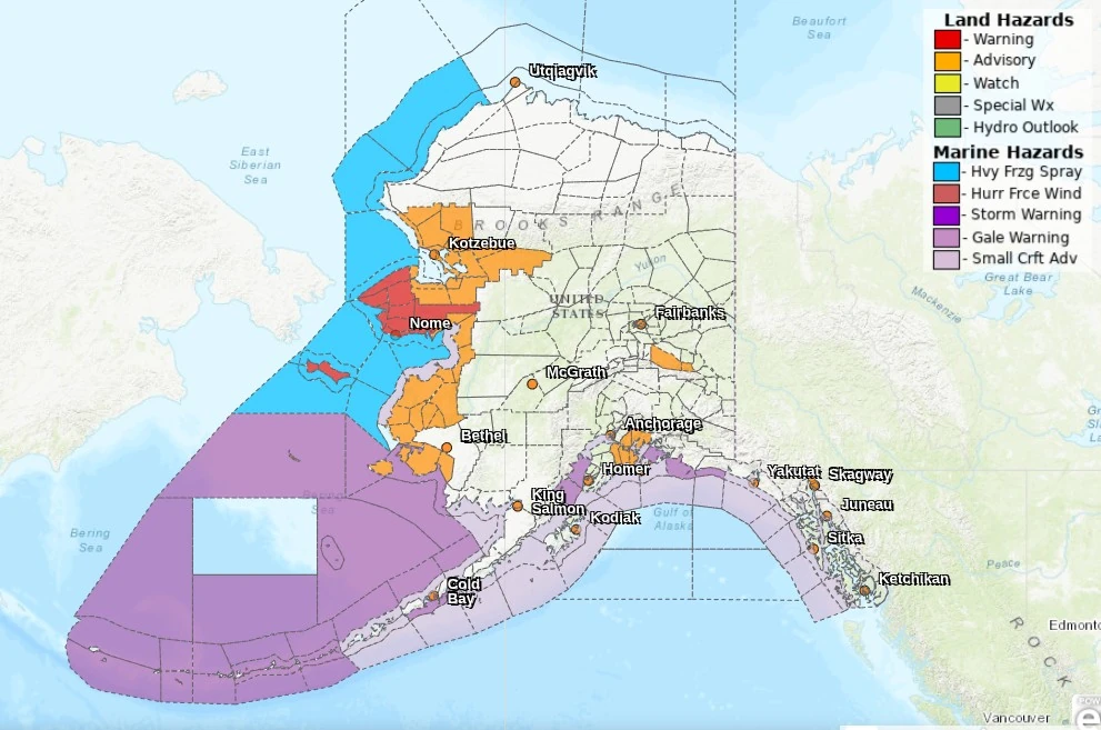
North of the Delta, a Winter Storm Warning is in effect for the Bering Strait Coast from 09:00 AKST Monday through 15:00 AKST Wednesday, November 19. The warning includes Wales, Brevig Mission, Teller, Diomede, and Shishmaref, where periods of snow and blowing snow will reduce visibility and create hazardous travel on exposed routes and coastal approaches.
Additional Winter Storm Warnings are in place for the Southern and Interior Seward Peninsula from 03:00 AKST Monday to 15:00 AKST Wednesday. Communities in these zones include Nome, Golovin, White Mountain, Council, Taylor, Pilgrim Springs, Serpentine Hot Springs, and Haycock.
Forecast snowfall totals are 20–30 cm (8–12 inches), with locally higher amounts in higher terrain, and wind gusts up to 65 km/h (40 mph). Localized blizzard conditions are possible at times as winds increase with heavier snow bands.
In Nome, the forecast calls for blowing snow developing early Monday with a Winter Storm Warning valid through Wednesday afternoon. Similar timing applies to nearby coastal and inland segments of the Seward Peninsula, with intermittent whiteouts possible where winds align with open tundra and coastal exposures.
Marine conditions remain hazardous along the Kuskokwim Delta waters, where a Gale Warning is in effect through Monday. Mariners should review coastal and offshore forecasts for zone-specific winds and seas and adjust plans accordingly.
“If you must travel, keep an extra flashlight, food, and water in your vehicle in case of an emergency,” meteorologists at the NWS office in Fairbanks said. “The latest road conditions for the state you are calling from can be obtained by calling 5 1 1.”
I'm a dedicated researcher, journalist, and editor at The Watchers. With over 20 years of experience in the media industry, I specialize in hard science news, focusing on extreme weather, seismic and volcanic activity, space weather, and astronomy, including near-Earth objects and planetary defense strategies. You can reach me at teo /at/ watchers.news.
Commenting rules and guidelines
We value the thoughts and opinions of our readers and welcome healthy discussions on our website. In order to maintain a respectful and positive community, we ask that all commenters follow these rules.