
Early-season freeze impacts large parts of the Texas and Oklahoma Panhandles and New Mexico
Widespread Freeze Warnings are in effect across the Texas and Oklahoma Panhandles and parts of New Mexico on Thursday, October 30, 2025, with temperatures forecast to drop to −6°C to −2°C (20°F–28°F). This is the first significant freeze of the season across the southern High Plains. The warnings remain valid through early Friday morning as clear skies and light winds enable rapid radiational cooling. Residents are advised to protect plants, pipes, and pets.
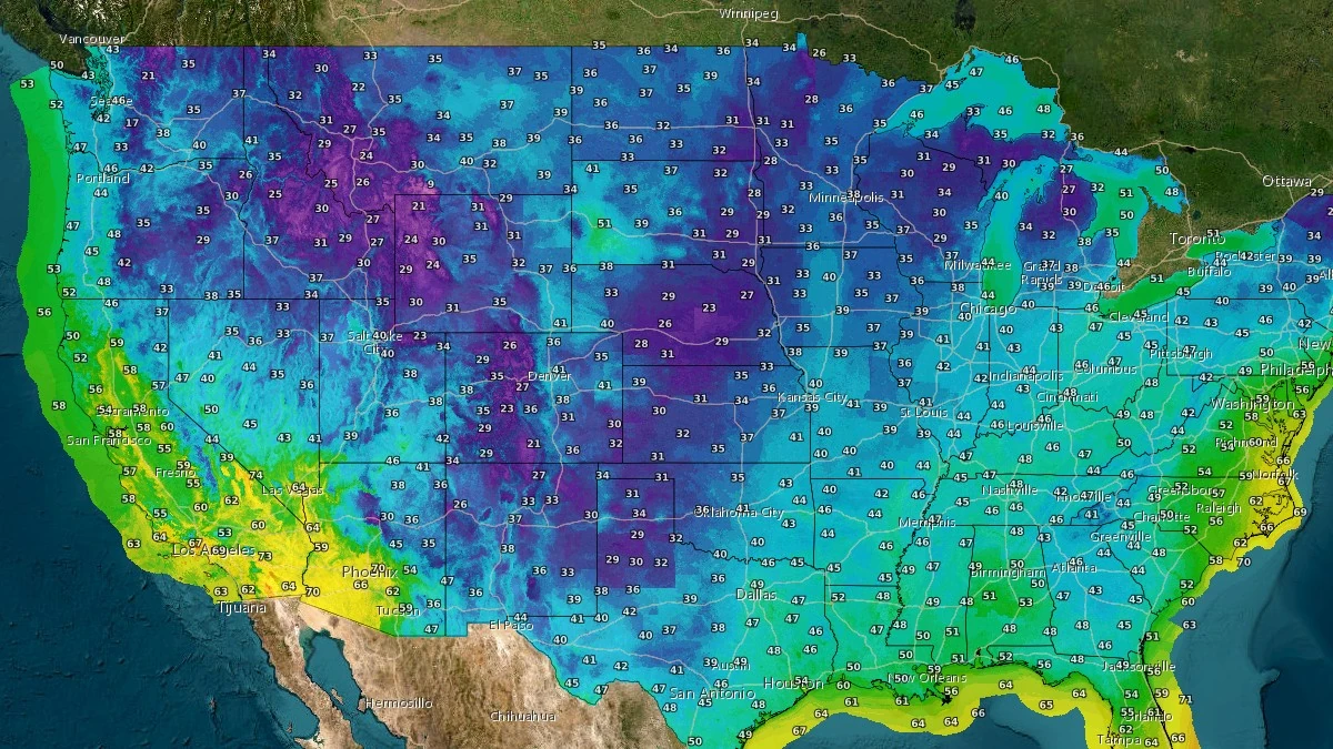
Temperatures (°F) at 08:30 UTC on October 30, 2025. Credit: NWS
A strong cold front moving southward across the central United States has brought the first widespread freeze of the 2025–26 cold season to the southern High Plains.
The National Weather Service (NWS) has issued Freeze Warnings across the Texas and Oklahoma Panhandles, and much of eastern and central New Mexico, valid through the morning of October 31.
Early Thursday temperatures are expected to range between −6°C and −2°C (20°F–28°F) across most lowland areas, with colder pockets possible in valleys and higher elevations. This represents values about 8°C (14°F) below the late-October climatological average, marking the strongest early-season cold outbreak so far this autumn.


According to the NWS Amarillo, the combination of clear skies, light winds, and a cold, dry air mass will allow efficient overnight cooling. Similar conditions are reported by the NWS Albuquerque, where radiational losses under a surface high-pressure ridge are forecast to produce sub-freezing temperatures across central New Mexico, including the Rio Grande Valley.
Meteorological analysis from the NOAA Weather Prediction Center (WPC) shows the cold air mass originated in the northern Rockies and central Plains, following a midweek frontal passage.
The system continues to advance southeastward under a building surface ridge extending into the Southern Plains. Model guidance (GFS and ECMWF 00:00 and 06:00 UTC runs) maintains below-normal temperatures through the weekend, with daytime highs expected to remain 5–10°C (9–18°F) below seasonal norms.
The NWS advises residents to take protective measures for plants, pipes, and outdoor animals.
Agricultural agencies warn that unharvested crops and ornamental vegetation could sustain damage due to freezing temperatures lasting several hours.
Water utilities across parts of New Mexico and the Texas Panhandle have issued precautionary notices for rural customers regarding exposed plumbing.
No significant precipitation or wind impacts are forecast during this period, as the air mass remains dry and stable. Temperatures are expected to gradually moderate by early next week as southerly flow returns to the region.
I'm a dedicated researcher, journalist, and editor at The Watchers. With over 20 years of experience in the media industry, I specialize in hard science news, focusing on extreme weather, seismic and volcanic activity, space weather, and astronomy, including near-Earth objects and planetary defense strategies. You can reach me at teo /at/ watchers.news.
Commenting rules and guidelines
We value the thoughts and opinions of our readers and welcome healthy discussions on our website. In order to maintain a respectful and positive community, we ask that all commenters follow these rules.