
Strong M6.7 aftershock hits Mindanao, Philippines hours after deadly M7.4
A strong and shallow earthquake registered by the USGS as M6.7 struck Mindanao, Philippines, at 11:12 UTC (19:12 LT) on October 10, 2025. The agency is reporting a depth of 61 km (38 miles). According to the Pacific Tsunami Warning Center (PTWC), there is no tsunami threat from this event. This event is considered a significant aftershock of the powerful M7.4 earthquake that hit the same region earlier the same day.
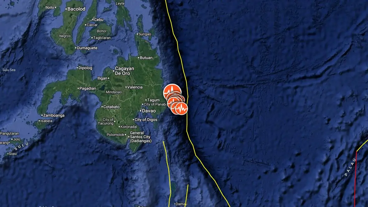
Epicenter of M6.7 earthquake in Mindanao, Philippines on October 10, 2025. Credit: TW/SAM, Google
The epicenter was located 24 km (14.9 miles) ESE of Santiago (population 2 631), 24 km (15.1 miles) ESE of Manay (population 20 336), 50 km (30.9 miles) SSE of Baganga (population 10 106), 64 km (39.9 miles) ENE of Mati (population 105 908), and 127 km (78.7 miles) E of Davao (population 1 776 949), Philippines.
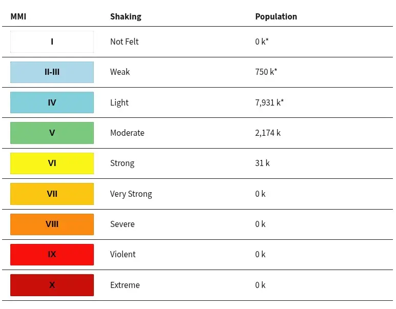
About 31 000 people are estimated to have felt strong shaking, 2 174 000 moderate, and 7 931 000 light.
There is no tsunami threat from this earthquake, according to the Pacific Tsunami Warning Center (PTWC).
The USGS issued a Green alert for shaking-related fatalities and economic losses. There is a low likelihood of casualties and damage.
Overall, the population in this region resides in structures that are a mix of vulnerable and earthquake-resistant construction. The predominant vulnerable building types are miscellaneous and heavy wood frame structures.
Recent earthquakes in this area have caused secondary hazards such as landslides that might have contributed to losses.
Liquefaction triggered by this earthquake is estimated to be limited in severity and spatial extent. The number of people living near areas that could have experienced liquefaction is limited.
Little or no landsliding is expected, but some landslides could have occurred in highly susceptible areas, and the number of people living near areas that could have produced landslides in this earthquake is low.
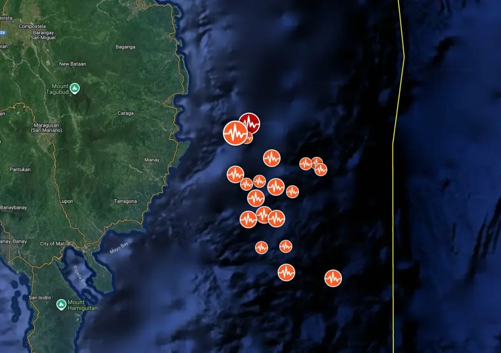
This event is considered a significant aftershock of the powerful M7.4 earthquake that hit the same region earlier the same day.
The Office of Civil Defense (OCD) Region XI confirmed that at least two people were killed in Mati City as a result of the M7.4 earthquake. The Davao City Government separately reported one fatality within the city. This brings the officially confirmed death toll to three, as of 21:00 PHT.
Regional media citing OCD officials reported that the total number of fatalities may reach five, including two people killed in a landslide in Pantukan, Davao de Oro, and two hospital patients who suffered heart attacks, but these figures remain under verification by national authorities.
Structural damage has been reported in several localities. In Tagum City, Tagum Doctors Hospital sustained visible cracks, while the Francisco Bangoy International Airport in Davao City reported minor damage to walls, though flight operations continued.
A landslide occurred in Pantukan, Davao de Oro, following the quake, prompting temporary road closures and search operations by local rescue teams.
The quake triggered tsunami warnings along the eastern coast of Mindanao and parts of the Davao Gulf, leading to precautionary evacuations. The PHIVOLCS and the Pacific Tsunami Warning Center (PTWC) later lifted the advisories after confirming no destructive tsunami was generated.
Power interruptions were reported in parts of Davao Oriental and Compostela Valley, but most service was restored by evening. Local governments suspended classes and advised residents to remain alert due to possible aftershocks. PHIVOLCS recorded multiple aftershocks of M4–M5 range within the first six hours after the main event.
As of this report, the National Disaster Risk Reduction and Management Council (NDRRMC) has not yet released an official consolidated situation report. Regional OCD and LGU updates remain the primary authoritative data sources. Damage assessment and search operations continue.

Update
15:33 UTC, October 11
Updated figures compiled by local disaster agencies cite at least nine deaths and more than 941 injured, though these numbers are still being verified and are likely to change as rescue and assessment operations continue.
Damage reports indicate widespread structural impacts in Davao Oriental, Davao de Oro, and neighboring provinces. Residential homes, public buildings, schools, and hospitals were among the most affected.
Damage includes cracked walls, collapsed facades, and damaged bridges in several towns. Power interruptions were reported in parts of Mindanao due to damaged transmission lines, while communication disruptions briefly hampered rescue coordination. Emergency response teams have been deployed, with search and rescue operations focused on communities near the epicenter.Updated figures compiled by local disaster agencies cite at least nine deaths and more than 941 injured, though these numbers are still being verified and are likely to change as rescue and assessment operations continue.
Damage reports indicate widespread structural impacts in Davao Oriental, Davao de Oro, and neighboring provinces. Residential homes, public buildings, schools, and hospitals were among the most affected.
Damage includes cracked walls, collapsed facades, and damaged bridges in several towns. Power interruptions were reported in parts of Mindanao due to damaged transmission lines, while communication disruptions briefly hampered rescue coordination. Emergency response teams have been deployed, with search and rescue operations focused on communities near the epicenter.
Estimated population exposure to earthquake shaking

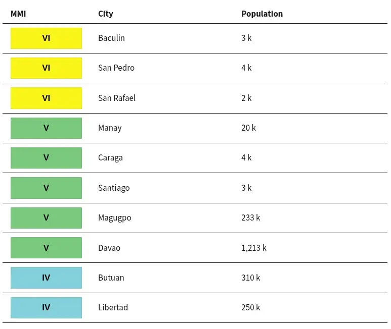
Selected cities exposed
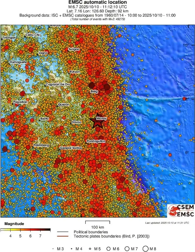
Regional seismicity
References:
1 M6.7 earthquake Mindanao, Philippines – USGS – October 10, 2025
2 M6.7 earthquake Mindanao, Philippines – EMSC – October 10, 2025
3 M6.7 earthquake Mindanao, Philippines – PTWC – October 10, 2025

Teo Blašković founded The Watchers in 2011 and edited it until 2026, covering seismic and volcanic activity, extreme weather, space weather and near-Earth objects. Articles on this page are his archive.
Published in the last 24 hours
- In September 1859, a solar storm lit up the night sky so brightly that gold miners in the Rocky Mountains woke up after midnight and started cooking breakfast, convinced the aurora glowing over their camp was the sunrise Epicenter
- A patch of warm Pacific water that could become the strongest El Niño in more than 70 years sits thousands of miles from any American town, yet it is already the main reason NOAA expects a wetter winter across the South and a milder one across the North
- A 19-year-old Nebraska teacher reportedly tied her pupils together with twine and led them to safety through a blizzard in January 1888 Epicenter
- NASA built the Opportunity rover to last 90 days on Mars, and Martian winds helped keep it alive for nearly 15 years by blowing dust off its solar panels, until a planet-wide dust storm in 2018 blocked sunlight and silenced the rover Epicenter

Overall good report, but should hold off on landslide info as it’s difficult to assess. Previous quake in Cebu north area same comment about low risk of landslides, yet 15 people died from one. Too many factors and dynamics in landslides forecasting.