
Strong North Pacific SST anomaly raises probability of colder winter 2025/26 in U.S. and Canada
A large sea surface temperature anomaly has developed in the North Pacific Ocean, extending toward the U.S. West Coast. Forecasts suggest the anomaly could help trigger colder-than-average conditions across central and eastern United States and Canada during the upcoming 2025/26 winter season, with a weak La Niña further reinforcing the setup.

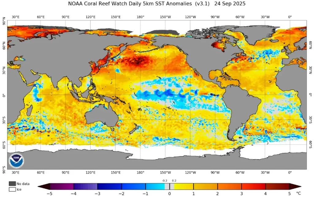
Sea surface temperature anomalies Pacific Ocean - September 24, 2025. Credit: NOAA/OSPO
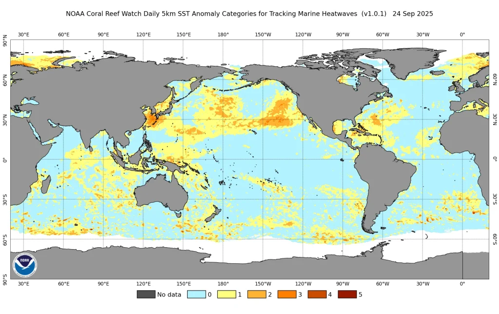
A significant sea surface temperature (SST) anomaly is growing across the North Pacific, with monitoring systems identifying it as among the largest heatwave events since 2013.
Data from NOAA’s Coral Reef Watch show persistent positive anomalies stretching from the western basin toward the North American coast, creating conditions known to influence atmospheric circulation through the “atmospheric bridge.”
Such anomalies modify the position and strength of the jet stream, altering pressure fields over the Pacific–North American region.
When a strong warm pool persists, the downstream effect often favors the development of a ridge over the northeast Pacific and a trough over the central and eastern United States. This configuration increases the probability of Arctic air intrusions into North America, raising the likelihood of colder-than-average winters in those regions.
The 2013–2015 “warm blob” in the northeast Pacific coincided with altered winter circulation patterns. While the western U.S. experienced persistent warmth and drought, much of central and eastern North America saw colder winters and enhanced snowfall.
Current monitoring indicates that the 2025 anomaly (NEP25A) has grown to an area of around 8 million km2 (3.1 million miles2), comparable to or exceeding some phases of the 2013–2015 event.
The emerging weak La Niña can act as an additional reinforcing influence. La Niña typically strengthens the jet stream over the northern Pacific, encouraging blocking patterns that divert cold air southward into Canada and the United States.
When combined with an existing marine heatwave anomaly, the atmospheric response can be amplified, leading to an increased probability of frequent or prolonged cold episodes.
The Pacific Northwest and coastal British Columbia may trend warmer under ridging patterns, while the U.S. Midwest, Great Lakes, and Northeast face higher chances of below-average temperatures and above-average snowfall. Western and northern Canada may also experience colder conditions.
While extended-range forecasts remain subject to uncertainty, current signals from the Pacific Ocean and coupled atmosphere–ocean models indicate an elevated likelihood that the North Pacific SST anomaly will play a major role in shaping the winter of 2025/26 across North America.
Secondary influences may extend into the North Atlantic and Europe, depending on the persistence and magnitude of the anomaly.
References:
1 A Strong Anomaly Grows in the North Pacific Ocean, hinting at a Colder Winter 2025/2026 – SWE – September 25, 2025
2 El Niño/Southern Oscillation (ENSO) diagnostic discussion – NWS/CPC – September 11, 2025

I am an Assistant Editor and Severe Weather & Science Journalist at The Watchers, specializing in real-time severe weather coverage, geophysical event reporting, and research-driven scientific analysis. You can reach me at rishav(at)watchers(.)news.
Commenting rules and guidelines
We value the thoughts and opinions of our readers and welcome healthy discussions on our website. In order to maintain a respectful and positive community, we ask that all commenters follow these rules.