
Flood watches issued in Kansas, Missouri, Oklahoma, and Arkansas, U.S.
Flood watches are in effect across parts of Kansas, Missouri, Oklahoma, and Arkansas on August 28, 2025, as widespread storms raise the threat of excessive rainfall and localized flooding in the south-central Plains and Lower Mississippi Valley.
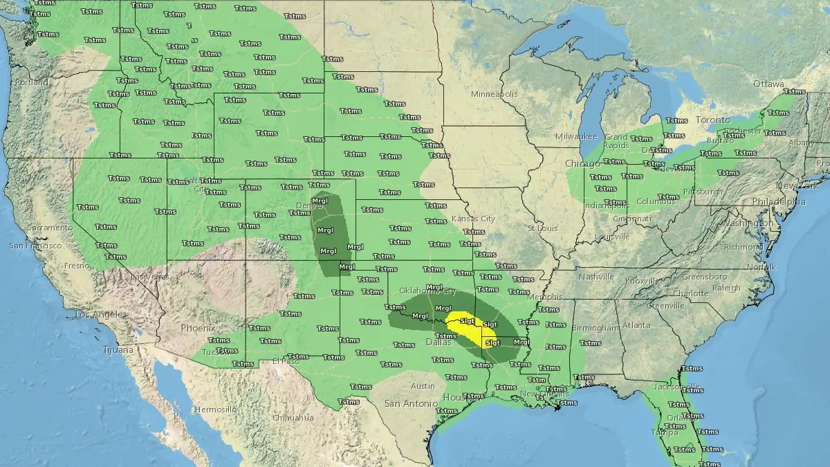
Convective Outlook for August 28, 2025. Credit: NWS
Widespread showers and thunderstorms are expected to continue across the south-central Plains and Lower Mississippi Valley today, August 28, as a combination of tropical moisture, frontal boundaries, and upper-level disturbances converge over the region.
The National Weather Service’s Weather Prediction Center (WPC) has maintained a Slight Risk (threat level 2/4) for Excessive Rainfall across eastern Oklahoma, western and central Arkansas, northeastern Texas, and northern Louisiana.
Flood watches are currently in effect for parts of central Kansas, far southwestern Missouri, northeast Oklahoma, and northwest Arkansas, where locally intense rainfall could overwhelm drainage systems and affect burn scar areas. Between this morning and early Saturday morning, rainfall totals of 50 to 100 mm (2 to 4 inches) are expected across the risk area, with locally higher amounts possible.
The setup includes a stationary front extending across the Central Plains and Arkansas Valley, enhanced by a developing surface low and upper-level troughs. Southerly low-level winds are transporting rich moisture from the Gulf of Mexico, increasing the potential for slow-moving, moisture-laden storms. The moisture is being further enhanced by residual mid- and upper-level moisture from weakening Tropical Storm Juliette, formerly located off the Baja California coast.
Meanwhile, a cold front traversing the Great Lakes will kick lake-effect rain showers back into high gear from Michigan on east into areas downwind of Lakes Erie and Ontario. Lake-effect rain showers should shut off by Friday, August 29, but the cold front marches across the Northeast where rounds of showers will make for an unsettled kick-off to Labor Day weekend from northern New York on east through much of New England.
On Friday, the threat axis will shift southward, with the Slight Risk extending across northern Louisiana and southern Mississippi and potentially into the Florida Panhandle and southern Georgia. The combination of saturated soils and additional rainfall raises the likelihood of localized flooding and flash flooding, especially in urban and low-lying areas.
To the west, marginally unstable air and lingering monsoon moisture will support additional showers and storms across the Rockies and High Plains, including parts of Colorado’s Front Range. A Slight Risk remains in effect for these areas as well due to possible runoff impacts in mountainous terrain and burn scars.
This rainfall comes amid a broader early-autumn pattern across the eastern United States, with daily temperatures ranging from 6°C to 9°C (10°F to 15°F) below seasonal norms. Highs in parts of the Arkansas Valley today may remain near or below daily records.
I'm a dedicated researcher, journalist, and editor at The Watchers. With over 20 years of experience in the media industry, I specialize in hard science news, focusing on extreme weather, seismic and volcanic activity, space weather, and astronomy, including near-Earth objects and planetary defense strategies. You can reach me at teo /at/ watchers.news.
Commenting rules and guidelines
We value the thoughts and opinions of our readers and welcome healthy discussions on our website. In order to maintain a respectful and positive community, we ask that all commenters follow these rules.