
Increased explosive activity, large pyroclastic flows at Fuego volcano, Guatemala
Fuego volcano in southern Guatemala began erupting on June 4, 2025, following weeks of increased activity. Explosions produced ash plumes reaching up to 4 800 m (15 750 feet) above sea level, and lava flows have impacted several nearby areas. Incandescent emissions, avalanches, and continued ashfall were reported, prompting heightened alerts and close monitoring. The activity continued into June 5, producing large pyroclastic flows and triggering the evacuation of nearby villages.
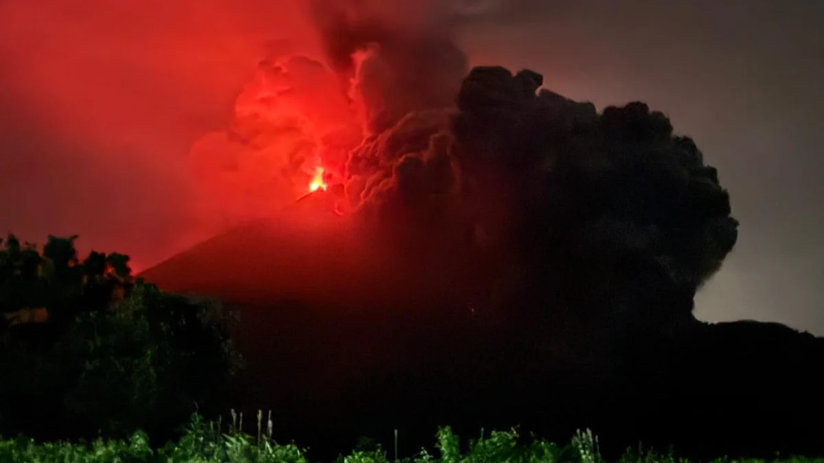
Eruption at Fuego volcano on June 4, 2025. Credit: CONRED
Fuego volcano exhibited multiple explosions on June 4 following a period of increased activity that began on May 27. According to local agencies, between five and eight explosions were recorded, each accompanied by loud sounds lasting from 1 to 13 minutes.
Gas and ash columns reached up to 4 800 m (15 750 feet) above sea level, drifting west and northwest. Overnight into the early hours of June 4, incandescent material was ejected up to 150 m (492 feet) above the crater.
Avalanches and a lava flow extending approximately 600 m (1 969 feet) were observed on multiple sides of the volcano, predominantly advancing toward the Seca and Ceniza ravines. Weather conditions in the region surrounding the stratovolcano remained clear.
From May 27 through June 3, Fuego volcano maintained a steady state of eruption, with near-constant activity reported by the National Institute for Seismology, Vulcanology, Meteorology, and Hydrology (INSIVUMEH). The volcano produced regular explosions, approximately 3 to 7 per hour, generating gas-and-ash plumes rising up to 1.1 km (3 600 feet) above the crater. The plumes drifted as far as 30 km (18.6 miles) toward the northwest, west, and southwest.
During nighttime activity, incandescent material was ejected 100 to 150 m (328 to 492 feet) above the crater, accompanied by rumbling sounds and occasional shock waves. Some explosions triggered block avalanches that descended multiple flanks, reaching vegetated areas.
Ashfall has been reported in several nearby communities, including Panimache I and II, Morelia, Santa Sofia, El Porvenir, and Finca la Asunción between May 27 and 28, and again in Panimache I and II and Yepocapa between June 1 and 2.
Fuego is one of the most active volcanoes in Central America, located just outside the city of Antigua at an elevation of 3 799 m (12 464 feet). It sits alongside two other large stratovolcanoes, Acatenango and the older Meseta, whose collapsed structure left behind a massive debris field that stretches nearly 50 km (31 miles) onto the Pacific coastal plain. Fuego began forming after the collapse of Meseta, continuing a volcanic migration southward from Acatenango.
Its long history of activity dates back to at least the early 1500s, with records showing frequent and often intense eruptions. Fuego’s eruptions have shifted in composition over time, becoming increasingly mafic and now mostly producing basaltic lava.
These events have brought major ashfalls, lava flows, and occasional pyroclastic flows that pose ongoing risks to nearby communities. Because of its frequent eruptions and proximity to populated areas, Fuego is closely monitored and considered one of the most hazardous volcanoes in the region.
Update
18:51 UTC, June 5
Large pyroclastic flows were observed at the volcano on June 5, prompting officials to begin preventive evacuation of nearby villages.
Several pyroclastic flows have descended primarily through the Las Lajas, Ceniza, and Seca ravines, reaching distances of up to 7 km (4.3 miles) downslope. The flows exhibited moderate to strong intensity and consisted of ash clouds and volcanic blocks.
“Given that the wind is blowing toward the northwest, west, and southwest, the ashfall is expected to affect communities mainly in the municipalities of Acatenango and San Pedro Yepocapa,” National Institute for Seismology, Volcanology, Meteorology and Hydrology (INSIVUMEH) said.
VOLCÁN DE FUEGO GUATEMALA Se registra el primer flujo piroclástico a las 4:21am pic.twitter.com/SAjGwAbTb1
— Diario de Los Altos (@DdeLosAltos) June 5, 2025
Pyroclastic density currents are a mixture of gases, ash, and high-temperature rock fragments that descend rapidly down the volcano’s flanks. These flows can cause death by burns and/or asphyxiation, and for this reason, it is advised not to remain in or near the volcano’s ravines, INSIVUMEH officials said.
It is also not ruled out that additional pyroclastic flows of weak, moderate, or strong intensity may occur in the coming hours, potentially reaching further into the ravines or other channels of the volcano.

My passions include trying my best to save a dying planet, be it through carpooling or by spreading awareness about it. Research comes naturally to me, complemented by a keen interest in writing and journalism. Guided by a curious mind and a drive to look beyond the surface, I strive to bring thoughtful attention and clarity to subjects across Earth, sciences, environment, and everything in between.
Commenting rules and guidelines
We value the thoughts and opinions of our readers and welcome healthy discussions on our website. In order to maintain a respectful and positive community, we ask that all commenters follow these rules.