
Lahars, pyroclastic flows, and ash from Fuego eruption force evacuations, close schools
Increased volcanic activity at Fuego in Guatemala forced the evacuation of an estimated 700 people from several villages in Chimaltenango on June 5, 2025. Heavy rains worsened conditions by triggering lahars that blocked roads and hampered emergency efforts. Authorities have closed schools, shut down roads, and issued an orange alert.
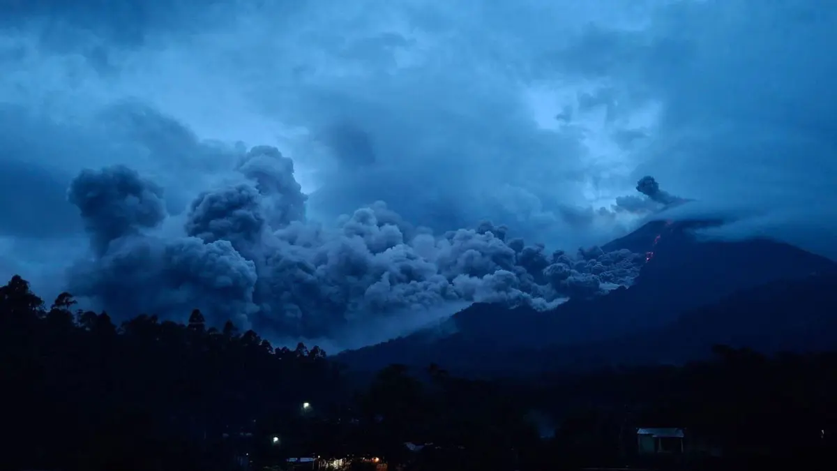
Pyroclastic flows from Fuego Volcano on June 5, 2025. Credit: Clima Guatemala
Increased activity at Fuego volcano on June 5 forced the evacuation of about 700 people from the villages of Panimaché I, Panimaché II, and Morelia, all located in the municipality of San Pedro Yepocapa, Chimaltenango. Heavy rains have intensified the flow of lahars, blocking important roads around the volcano and making evacuation/emergency access difficult.
Classes have been called off at 43 schools across Chimaltenango, Escuintla, and Sacatepéquez as a safety measure ordered by the Ministry of Education. Authorities have also shut down National Route 14 as a precaution.
Las lluvias que se registran en el área del volcán de Fuego generan el descenso de lahares por distintas barrancas. Recomendamos evitar poner en riesgo su vida ubicándose cerca de barrancas o intentar cruzarlas. ¡la prevención es tarea de todos! pic.twitter.com/cRQvswQBWW
— CONRED (@ConredGuatemala) June 5, 2025
Ongoing pyroclastic flows of varying strength continue to move down the ravines of the volcano, traveling as far as 7 km (4.3 miles). A lava flow of about 1.2 km (0.75 miles) moving from the crater into the Ceniza ravine, with glowing material clearly visible, has also been observed.
Bursts of incandescent material were seen being ejected more than 300 m (984 feet) above the crater, accompanied by weak to moderate rumbling sounds lasting up to five minutes.
Emergency crews, including Immediate Response Teams, Strategic Intervention units, departmental delegates, and field staff, were deployed to affected areas starting last night. A shelter has been set up at the Santa Lucía Cotzumalguapa sports center in Escuintla to assist evacuees.
A warning has been issued to the Civil Aviation Authority to take precautions with air traffic near the volcano, as ash could spread up to 50 km (31 miles) northwest, west and southwest at altitudes between 3 000 and 4 800 m (9 843 to 15 091 feet). The ash cloud may continue to grow depending on wind conditions and eruption intensity, hence pilots are urged to check upcoming ash dispersion forecasts.
Ashfall is predicted to worsen in the areas of Panimaché I & II, Morelia, Los Yucales, Santa Sofía, El Porvenir, San Pedro Yepocapa and Acatenango.
With Fuego showing increased activity, an orange alert has been activated. People in the surrounding areas are urged to stay alert and follow official instructions. Access to both Fuego and Acatenango is currently prohibited, and approaching nearby ravines could be dangerous due to ongoing volcanic activity.
In areas affected by ash, wearing a mask is strongly recommended. Families should review their emergency plans, make sure their 72-hour kits are stocked and ready, and be prepared to evacuate on short notice if conditions worsen.

My passions include trying my best to save a dying planet, be it through carpooling or by spreading awareness about it. Research comes naturally to me, complemented by a keen interest in writing and journalism. Guided by a curious mind and a drive to look beyond the surface, I strive to bring thoughtful attention and clarity to subjects across Earth, sciences, environment, and everything in between.
Commenting rules and guidelines
We value the thoughts and opinions of our readers and welcome healthy discussions on our website. In order to maintain a respectful and positive community, we ask that all commenters follow these rules.