
Severe thunderstorms and heavy rainfall forecast across southern U.S. during Memorial Day weekend
A slow-moving storm system extending from the southeastern United States to the Central Rockies is forecast to bring severe thunderstorms and heavy rainfall to much of the southern U.S. during Memorial Day weekend, beginning Saturday, May 24, 2025.

Excessive Rainfall Outlook for May 25, 2025. Credit: WPC
A quasi-stationary front extending from the southeastern United States through the Southern Plains to the Central Rockies is expected to bring unsettled weather to the region throughout Memorial Day weekend.
Moisture flowing from the Gulf of America is anticipated to interact with the front on Saturday, May 24, leading to thunderstorms and heavy rainfall over parts of the central and southern Plains, as well as the middle and lower Mississippi Valley.
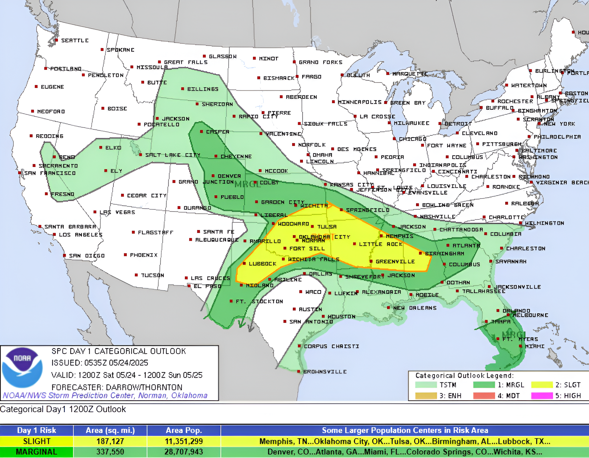
The Weather Prediction Center (WPC) has issued a Slight Risk (level 2 of 4) for excessive rainfall over the region through Sunday, May 25. Localized flash flooding is possible in urban and low-lying areas.

Meanwhile, the Storm Prediction Center (SPC) has issued a Slight Risk (level 2 of 5) for severe thunderstorms over parts of the central and southern Plains, the middle and lower Mississippi Valley, and the Tennessee Valley through Sunday.
Frequent lightning, severe thunderstorms, wind gusts, hail, and a few tornadoes are possible across the risk zone. Notably, there is an elevated risk of hail up to 5 cm (2 inches) or larger in the Southern Plains.
On Sunday, the continued northward flow of moisture is expected to increase the threat of heavy rainfall and thunderstorms over the central and southern Plains, the middle and lower Mississippi Valleys, and the Tennessee Valley.
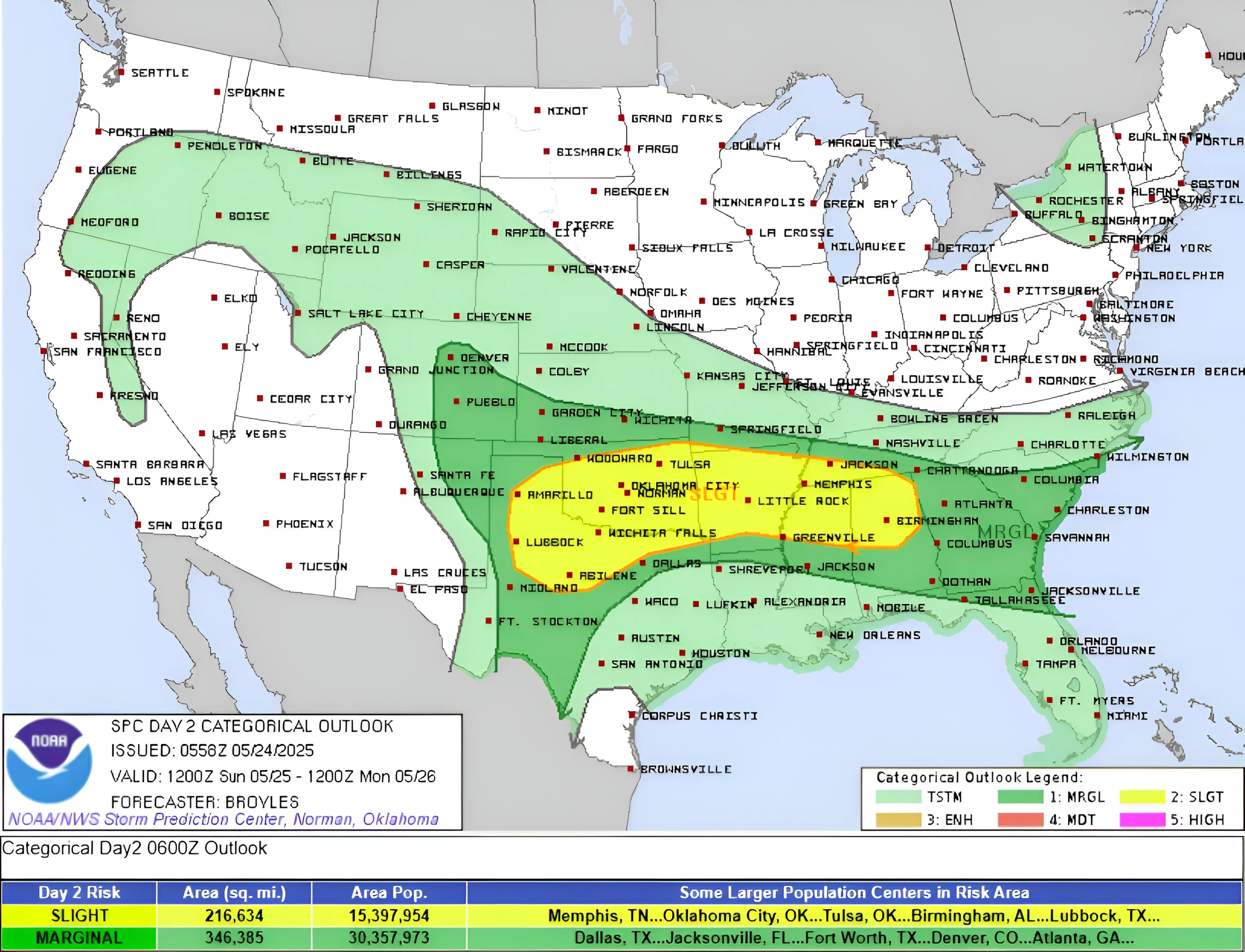
The WPC has issued a Moderate Risk (level 3 of 4) for excessive rainfall over parts of the central and southern Plains, as well as the middle and lower Mississippi Valley, from Sunday through Monday morning, May 26.
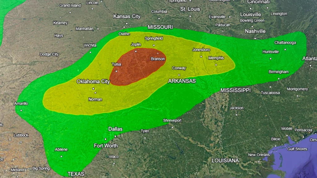
Flash flooding is likely in many areas as small streams overflow within the risk zone. Larger rivers may also be affected by heavy rainfall, potentially leading to flooding in some regions.
The SPC has issued a Slight Risk (level 2 of 5) for severe thunderstorms over parts of the Southern Plains, the middle and lower Mississippi Valley, and the Tennessee Valley from Sunday through Monday.

I am an Assistant Editor and Severe Weather & Science Journalist at The Watchers, specializing in real-time severe weather coverage, geophysical event reporting, and research-driven scientific analysis. You can reach me at rishav(at)watchers(.)news.
Commenting rules and guidelines
We value the thoughts and opinions of our readers and welcome healthy discussions on our website. In order to maintain a respectful and positive community, we ask that all commenters follow these rules.