
Shallow M5.4 earthquake, series of aftershocks hit Texas–New Mexico border region
A shallow earthquake registered by the USGS as M5.4 struck Culberson County, Texas, near the New Mexico border, at 01:47 UTC on May 4, 2025 (20:47 LT on May 3). The agency reports a depth of 7.5 km (4.6 miles). The earthquake occurred in an area of intense oil and gas activity within the Permian Basin.

Location of M5.4 earthquake near Texas - New Mexico border at 01:47 UTC on May 4, 2025. Credit: TW/SAM, Google
The quake was initially measured at M5.3 before being upgraded to M5.4, making it one of the strongest earthquakes recorded in this region in recent decades.
The epicenter was located 59 km (37 miles) south of Whites City (population 7) and 89 km (55 miles) south-southwest of Carlsbad (population 28 957), New Mexico.
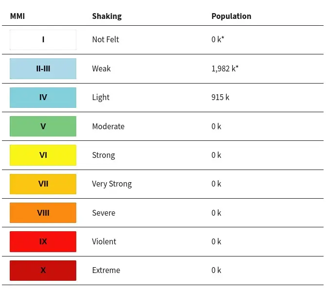
915 000 people are estimated to have felt light shaking, and 1 982 000 weak.
As of now, there are no reports of significant damage or injuries resulting from the earthquake.
The USGS issued a Green alert for shaking-related fatalities and economic losses. There is a low likelihood of casualties and damage.
Overall, the population in this region resides in structures that are resistant to earthquake shaking, though vulnerable structures exist. The predominant vulnerable building types are unreinforced brick masonry and reinforced masonry construction.
The USGS identified this quake as the potential mainshock of an earthquake sequence, with 66 events with magnitudes up to 3.2 detected over the next 4 hours.
According to their forecast, there is a 3% chance of one or more aftershocks larger than magnitude 5, which could be damaging, within the next week. Smaller aftershocks are likely during this period, with up to 19 expected at magnitude 3 or greater. These may be felt in nearby areas. While the overall number of aftershocks is expected to decrease over time, a significant aftershock could temporarily increase seismic activity.
The agency received over 1 500 felt reports from areas as far as 720 km (447 miles) away.


The earthquake occurred in an area of intense oil and gas activity within the Permian Basin, one of the most productive hydrocarbon regions in the United States.
Culberson County hosts thousands of drilled wells and active permits, with extensive hydraulic fracturing and deep wastewater injection operations. Seismologists have linked similar earthquakes in the region to the injection of saltwater, a byproduct of oil production, into deep underground formations, which increases subsurface pore pressure and can induce earthquakes.
The area is being monitored by the Texas Railroad Commission (RRC), the state’s oil and gas regulator, which has implemented restrictions on wastewater injection in response to rising seismicity.
In recent years, the RRC has reduced permitted injection volumes and temporarily suspended operations in parts of West Texas. The measures are part of a broader effort to mitigate induced earthquakes in the Permian Basin.
Estimated population exposure to earthquake shaking

Selected cities exposed

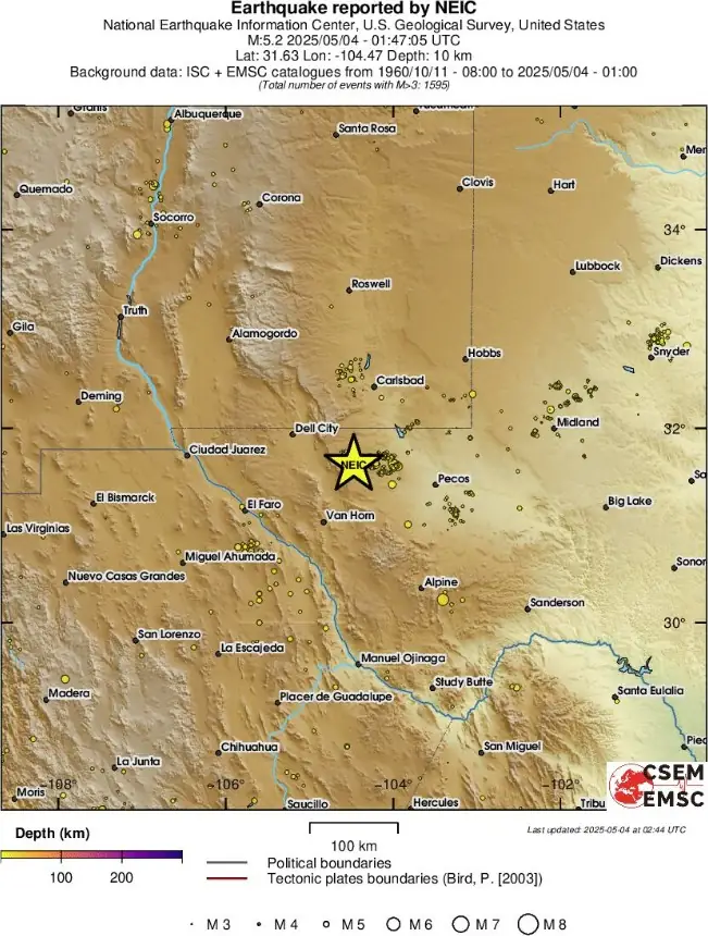
Regional seismicity

References:
1 M5.4 earthquake Texas-New Mexico border – USGS – May 4, 2025

Teo Blašković founded The Watchers in 2011 and edited it until 2026, covering seismic and volcanic activity, extreme weather, space weather and near-Earth objects. Articles on this page are his archive.
Published in the last 24 hours
- In September 1859, a solar storm lit up the night sky so brightly that gold miners in the Rocky Mountains woke up after midnight and started cooking breakfast, convinced the aurora glowing over their camp was the sunrise Epicenter
- A patch of warm Pacific water that could become the strongest El Niño in more than 70 years sits thousands of miles from any American town, yet it is already the main reason NOAA expects a wetter winter across the South and a milder one across the North
- A 19-year-old Nebraska teacher reportedly tied her pupils together with twine and led them to safety through a blizzard in January 1888 Epicenter
