
Severe thunderstorms forecast for Central and Southern Plains, U.S.
A slow-moving frontal boundary is forecast to trigger thunderstorms across the Central and Southern Plains of the United States on April 24, 2025, with risks of severe weather including large hail, strong wind gusts, and flash flooding. The system is expected to shift southeast, extending the storm threat into the Mississippi and Ohio Valleys, and eventually the Northeast and Southeast through April 26.
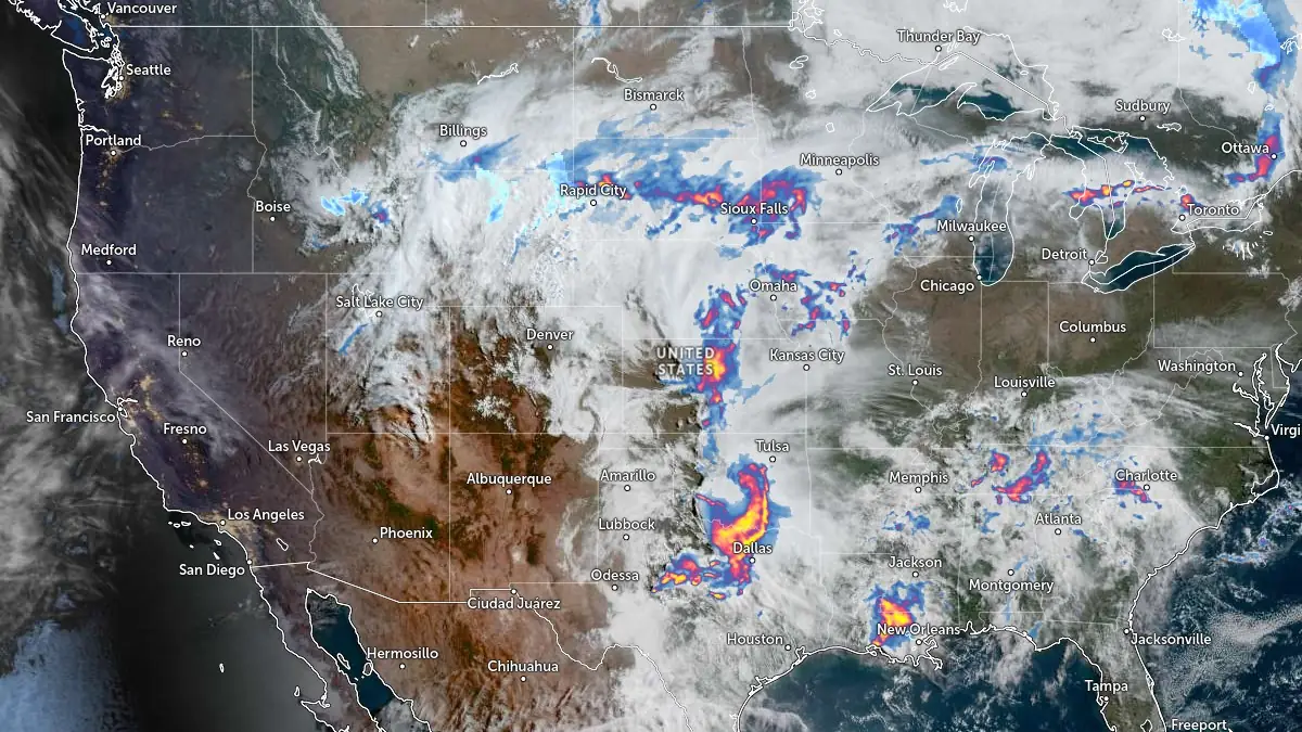
Image credit: NOAA/GOES-East, Zoom Earth, The Watchers. Acquired at 14:00 UTC (09:00 CDT) on April 24, 2025
“A slow-moving frontal boundary is expected to move southeast across the Central and Eastern U.S. over the next couple of days and will be the focus for daily thunderstorm activity through Saturday,” National Weather Service (NWS) meteorologist Dolan noted on April 24.
The frontal boundary will stretch from the Great Lakes to the Central Plains today, with a dry line likely extending to the south across western Texas.
This will result in an environment favorable for strong to severe thunderstorms to develop today in the Central and Southern Plains, with warm moist air in place while an upper level shortwave moves east across the region.
Isolated strong to severe thunderstorms are expected to develop, and severe storm hazards could include large hail and strong wind gusts. Additionally, thunderstorms are expected to produce heavy rain, which may lead to isolated to scattered instances of flash flooding.
Thunderstorms will also be possible across the Southeast today along a dying stationary boundary.

By Friday, April 25, a low-pressure system is expected to intensify near the Great Lakes, causing the frontal boundary to advance into the Mississippi and Ohio Valleys. The front is forecast to move into the Northeast, Mid-Atlantic, and Southeast by Saturday. These regions were likely to experience isolated strong to severe thunderstorms associated with the advancing system.
“A portion of the front will also remain stationary up against the Rockies, which should support continued precipitation chances through Friday, with heavy snow possible in the higher elevations of Wyoming today,” Dolan said.
At the same time, a deep upper-level low is forecast to approach the West Coast, bringing a cold front toward the California coast by April 26. Moisture from the Pacific is expected to spread into the region, increasing chances of widespread rain and high-elevation snow. Heavy snow is anticipated in the Sierra Nevada on Saturday.
Temperatures are expected to remain above average on the southern side of the front across the Central and Eastern U.S., with highs ranging from 21°C to 32°C (70°F to 90°F). Cooler conditions were forecast to persist north of the boundary.
As the front advanced, below-normal temperatures were expected to spread into affected regions, including the West Coast under the influence of the upper-level low.
References:
1 Short Range Forecast Discussion – NWS/WPC – April 24, 2025
I'm a dedicated researcher, journalist, and editor at The Watchers. With over 20 years of experience in the media industry, I specialize in hard science news, focusing on extreme weather, seismic and volcanic activity, space weather, and astronomy, including near-Earth objects and planetary defense strategies. You can reach me at teo /at/ watchers.news.
Commenting rules and guidelines
We value the thoughts and opinions of our readers and welcome healthy discussions on our website. In order to maintain a respectful and positive community, we ask that all commenters follow these rules.