
Major tornado outbreak forecast from lower Mississippi to Ohio valleys on Wednesday, April 2
A major tornado outbreak is forecast from parts of the lower Mississippi Valley into the Mid-South and lower Ohio Valley, with multiple long-track EF-3+ tornadoes possible across the region on Wednesday, April 2, 2025.

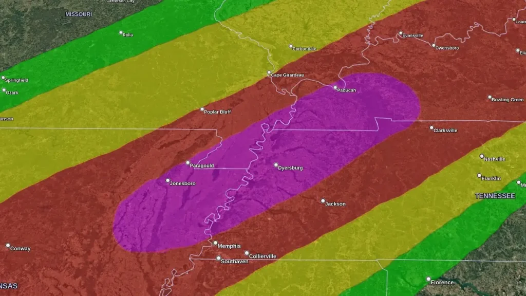
Level 5 threat of severe weather on April 2, 2025. Image credit: NWS/SPC
The Storm Prediction Center (SPC) has issued a High Risk (level 5/5) of severe weather across parts of the Lower Mississippi Valley into the Mid-South and Lower Ohio Valley. A major tornado outbreak is expected over the region, which could spawn multiple EF-3 tornadoes or higher on Wednesday, April 2.
A broader Enhanced Risk (level 3/5) of severe weather covers the rest of the region, from northern Texas to southern Michigan. Scattered but significant threats of tornadoes, large hail, and damaging winds are forecast for the region. The severe weather threat will be compounded by the beginning of a life-threatening flash flood event.
This outbreak is part of a larger multi-hazard weather system that is forecast to bring historic rainfall over parts of Kentucky, Tennessee, Missouri, and Illinois from Wednesday to Sunday.
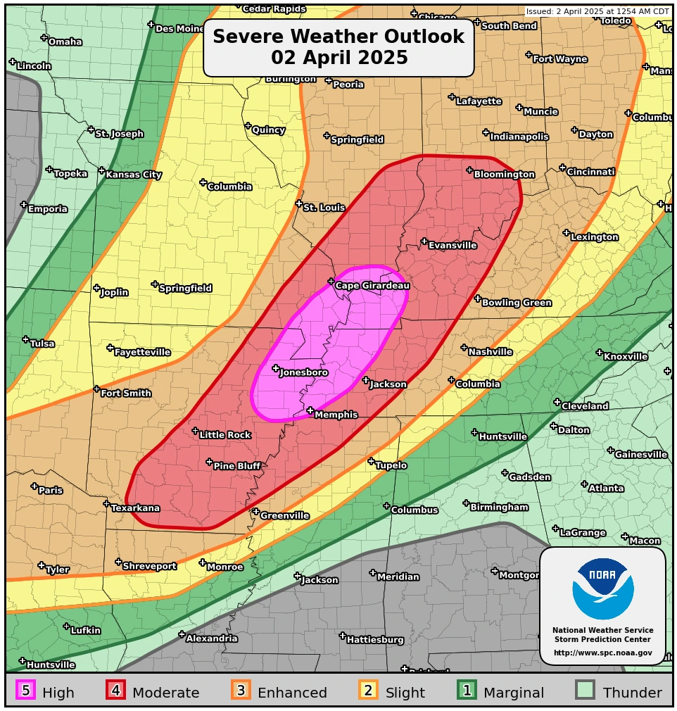
Regions under the severe weather threat include Western and Middle Tennessee, Arkansas, Western and Central Kentucky, Eastern Missouri, Illinois, Northern Mississippi, Indiana, Northern Louisiana, Western Ohio, areas extending north into Northeast Texas, and Southern Lower Michigan.
While numerous tornadoes would be the main threat across these regions, hurricane-force winds, along with the possibility of baseball-sized hail, are to be expected.
A Moderate Risk of Excessive Rainfall (level 3/4) is in effect on Wednesday, overlapping much of the SPC High Risk area from the Lower Ohio Valley southwestward into the Mid-South. This region has the highest potential for several inches of rainfall and scattered to numerous flash flooding events through the evening and overnight hours.
On Thursday, April 3, the front is expected to become nearly stationary across the region, increasing the risk of significant heavy rainfall. There is a 40–60 % probability of more than 152 mm (6 inches) of rain over the two-day period.
Repeated rounds of rainfall will saturate soils and may result in additional rainfall over areas already experiencing flooding.
Due to these conditions, another Moderate Risk is in place on Thursday for areas from the Lower Ohio Valley and Mid-South to the ArkLaTex. An embedded High Risk (level 4/4) is issued for western Kentucky, the Missouri Bootheel, northwestern Tennessee, and extreme northeastern Arkansas, where widespread, life-threatening flash flooding is expected.
The front is forecast to remain stalled into the weekend, with Moderate Risks already in place for Friday and Saturday.
This event may bring potentially historic rainfall totals, with some locations expected to receive 250–380 mm (10–15 inches) or more through the weekend.
Communities throughout the affected areas are advised to prepare for the potential of prolonged and severe disruptions due to the expected extreme rainfall and flood risks.
Additional severe thunderstorms are expected on Thursday from the Mid-Atlantic southwest through the Ohio and Tennessee Valleys into the Southern Plains. The SPC maintains a Slight Risk (level 2/5) for threats, including damaging winds, large hail, and a few tornadoes.
References:
1 Public severe weather outlook – NWS/SPC – April 2, 2025
2 Short Range Forecast Discussion – NWS/WPC – April 2, 2025

I am an Assistant Editor and Severe Weather & Science Journalist at The Watchers, specializing in real-time severe weather coverage, geophysical event reporting, and research-driven scientific analysis. You can reach me at rishav(at)watchers(.)news.
Commenting rules and guidelines
We value the thoughts and opinions of our readers and welcome healthy discussions on our website. In order to maintain a respectful and positive community, we ask that all commenters follow these rules.