
Blizzard warnings and winter weather alerts issued from Plains to Midwest ahead of powerful winter storm
Blizzard warnings and multiple winter weather alerts have been issued across the Central Plains and Midwest as a powerful winter storm is forecast to sweep through the region starting Tuesday, March 18, 2025. Strong winds of over 80 km/h (50 mph) and snow accumulation of up to 15 cm (6 inches) will create impossible travel conditions along key routes.

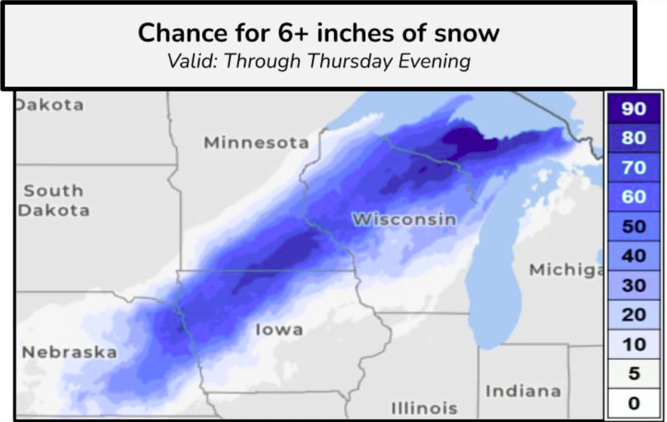
Snow accumulation forecast map ending at 17:00 ET on March 19, 2025. Image credit: NWS
A powerful winter storm is set to move across the Plains and Midwest on Tuesday, March 18, bringing heavy snowfall from Colorado to Wisconsin. Snowfall rates of 25–50 mm (1–2 inches) per hour or higher, along with wind gusts exceeding 80 km/h (50 mph), are expected in the affected areas.
Northern Kansas, southern Minnesota, and much of Wisconsin are expected to be the hardest-hit areas, with snowfall accumulations exceeding 15 cm (6 inches) through Thursday evening, March 20.
Blizzard warnings have been issued from Scott City in southwestern Kansas to Red Wing in southern Minnesota, covering much of Nebraska and northwestern Iowa. Winter weather advisories are in effect for parts of southeastern South Dakota and southern Minnesota. Additionally, winter storm warnings and wind advisories have been issued for portions of Nebraska, Colorado, Kansas, and Iowa.
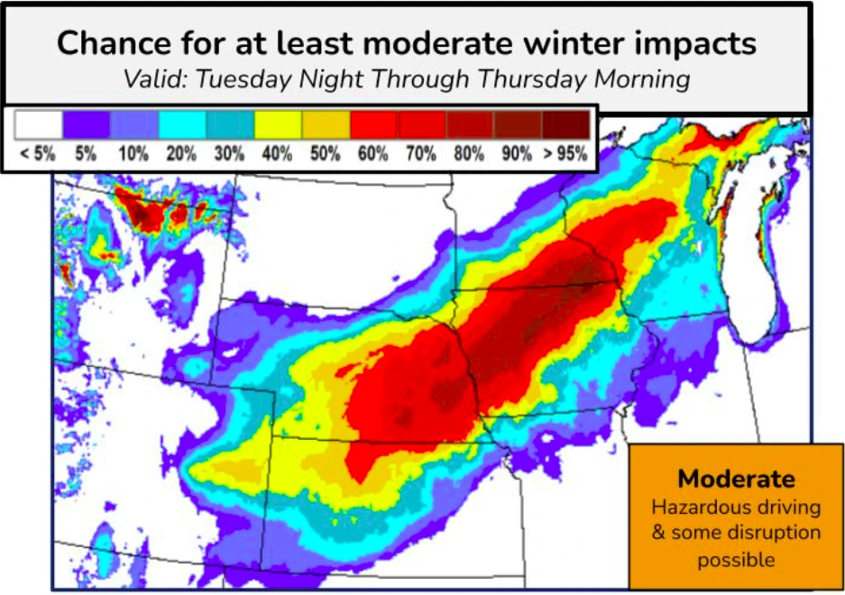
The low-pressure system is expected to intensify, bringing heavy snowfall to the Central Plains starting Tuesday night before moving through the Upper Midwest and western Great Lakes by Thursday morning.
Significant snowfall accumulations are expected from Nebraska to the Upper Peninsula of Michigan. The region has a more than 70% chance of seeing snowfall of 15 cm (6 inches), with a 30% chance of localized accumulations reaching up to 30 cm (12 inches) by Thursday evening.
Strong winds ranging from 80–95 km/h (50–60 mph), with localized gusts exceeding 130 km/h (80 mph), are forecast across the southern Plains from Tuesday into Wednesday.
The combination of strong winds and heavy snowfall is expected to cause blizzard conditions and whiteout visibility on roadways, making travel extremely hazardous or impossible. The National Weather Service (NWS) has advised residents in affected areas to avoid travel unless absolutely necessary.
Strong winds are likely to cause power outages and damage throughout the region. Portions of I-80, I-90, and I-35 in Iowa are expected to experience extremely hazardous travel conditions.
References:
1 Short Range Forecast Discussion – NWS -March 17, 2025

I am an Assistant Editor and Severe Weather & Science Journalist at The Watchers, specializing in real-time severe weather coverage, geophysical event reporting, and research-driven scientific analysis. You can reach me at rishav(at)watchers(.)news.
Commenting rules and guidelines
We value the thoughts and opinions of our readers and welcome healthy discussions on our website. In order to maintain a respectful and positive community, we ask that all commenters follow these rules.