
Severe storms forecast for the ArkLaTex and Mississippi Valley this weekend
Storms are forecast to sweep through the ArkLaTex region, the Lower and Middle Mississippi Valleys, and the Southeast starting Friday, March 14, 2025, bringing a risk of tornadoes, thunderstorms, and hail.
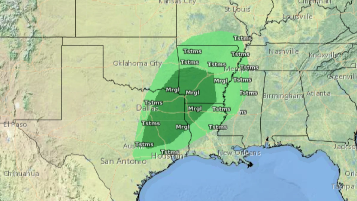
Convective outlook ending at 17:00 ET on March 13, 2025. Image credit: NWS/SPC
Severe storms are expected to sweep through the ArkLaTex region into the Middle and Lower Mississippi Valley starting Friday, March 14.
The storms will bring with them a risk of tornadoes, swaths of damaging winds, and hail to the region. On Saturday, March 15, the storms will move eastward, shifting the risk of severe weather to the Southeast.
There is some uncertainty regarding the north and east extent of the severe weather risk on Friday and Saturday. A more accurate forecast will be available in the next couple of days.
The National Weather Service (NWS) advised citizens to keep up with the forecasts to start preparing for severe weather events and to be aware of watches and warnings in the affected regions.

Meanwhile, a strong low-pressure system is expected to move into the northern tier states today, March 10, bringing strong winds and an increased risk of wildfires.
Ahead of this system, warm southerly winds will contribute to unusually high temperatures ranging from 10–21°C (50–70°F), with some isolated areas exceeding 21°C (70°F). These temperatures will be 11–22°C (20–40°F) above the seasonal average across the Northern and Central Plains and the Upper Midwest, where numerous records may be tied or broken.
The approaching cold front this afternoon and evening will moderate temperatures and heighten wildfire risks.
The Storm Prediction Center has issued a Critical Fire Risk for much of the Dakotas, where dry and windy conditions will support wildfire development.
An upper trough over the East Pacific is forecast to move across the Southwest on Tuesday, generating dry downslope winds from the Southern Rockies into the Southern High Plains.
Sustained winds of approximately 24–40 km/h (15–25 mph) will contribute to a Critical Fire Risk for parts of far southeastern Arizona, southern New Mexico, and far western Texas.
Elevated fire risk is expected to persist across the Southern High Plains through the rest of the week.
References:
1 Short Range Forecast Discussion – NWS/WPC – March 10, 2025

I am an Assistant Editor and Severe Weather & Science Journalist at The Watchers, specializing in real-time severe weather coverage, geophysical event reporting, and research-driven scientific analysis. You can reach me at rishav(at)watchers(.)news.
Commenting rules and guidelines
We value the thoughts and opinions of our readers and welcome healthy discussions on our website. In order to maintain a respectful and positive community, we ask that all commenters follow these rules.