
Back-to-back winter storms to impact U.S. Midwest and Northeast
Two winter storms are set to sweep across the U.S. Midwest, Great Lakes, and Northeast starting February 5, 2025, prompting Ice Storm Warnings and Winter Weather Warnings.

Snow fall forecast map through Thursday, February 6, 2025. Image credit: NWS/WPC
- The U.S. Midwest and Northeast will experience two winter storms, with the first arriving from February 5 – 6, followed by a second storm over the weekend (February 8 – 9)
- Areas including Western Maryland, the West Virginia Panhandle, and central/southern Pennsylvania have a 40 – 70 % chance of receiving more than 6.35 mm (0.25 inches) of ice, leading to hazardous conditions.
- Ice and snow will impact key highways, including Interstates 81, 89, 76, 70, 99, 68, and the I-95 corridor from New York City to Boston, causing difficult travel conditions.
- The Appalachians, parts of Pennsylvania, Maryland, West Virginia, and northern Virginia are under Ice Storm Warnings.
Back-to-back winter storms are expected to impact the U.S. Midwest and Northeast from Wednesday to Thursday, February 5 – 6. The first storm, named Winter Storm Freya by the Weather Channel, will be followed by another system affecting the region through the weekend.
A low-pressure system will bring moisture into an Arctic high-pressure system over the region, leading to the development of ice and snow due to the interaction between the two systems, beginning Wednesday, February 5.
Western Maryland, the West Virginia Panhandle, and central/southern Pennsylvania have a 40 – 70 % chance of receiving more than 6.35 mm (0.25 inches) of ice accumulation. Lighter but hazardous freezing rain accumulation is expected across the Midwest, Great Lakes, and northern Mid-Atlantic.
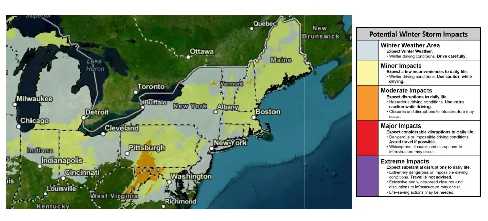
Ice accumulation will impact major routes, including Interstates 81, 89, 76, 70, 99, and 68. The I-95 corridor from New York City to Boston may experience snowfall or a wintry mix late Wednesday night or Thursday before transitioning to rain at some point during the day.
Ice Storm Warning and Winter Weather Advisories
Areas across the Appalachians, south-central Pennsylvania, the panhandles of Maryland and West Virginia, and northern Virginia are under Ice Storm Warnings, with a high likelihood of power outages, tree damage, and hazardous travel conditions.
Winter Weather Advisories have been issued for large portions of the Midwest, Appalachians, and Northeast, including Baltimore, Chicago, Des Moines, and Pittsburgh. Difficult travel conditions are expected in these areas.
Freezing rain and sleet will develop in northern Missouri and Iowa before spreading across the southern Great Lakes later Wednesday and overnight, affecting cities such as Chicago, Cleveland, and Detroit. Areas in central and northern Minnesota and northern Michigan are likely to receive most of the precipitation as snow.

Several areas across the Midwest and Great Lakes will experience freezing rain and sleet during the storm, with central and northern Minnesota and northern Michigan expected to receive the heaviest precipitation.
Hazardous travel conditions are likely across portions of the Mid-Atlantic, including Baltimore, Philadelphia, and Washington, D.C., due to sleet and freezing rain from Wednesday night into early Thursday, before transitioning to rain later in the morning.
Although not expected to be heavy, at least a few inches of snow are forecast from North Dakota and central and northern Minnesota to upstate New York and northern New England.

Second winter storm
The second winter storm will impact the Midwest and Northeast from Saturday to Sunday, February 8 – 9. A low-pressure system will bring moisture into retreating cold high pressure, leading to winter weather conditions.
Although it is still early for an accurate forecast of the second storm, a band of ice is likely to develop by Saturday from the Northern Plains and Great Lakes to parts of the Mid-Atlantic and Northeast.
The Interstate 95 corridor could see a burst of snow, including areas around New York City and Boston, before transitioning to a wintry mix or rain. By Sunday, much of the remaining snowfall will be over New England as the storm moves away.
References:
1 Short Range Forecast Discussion – NWS/WPC -February 5, 2025
2 Multiple Winter Storms To Bring Rounds Of Ice, Snow Across Portions Of Midwest, Northeast Into The Weekend – The Weather Channel – February 5, 2025

I am an Assistant Editor and Severe Weather & Science Journalist at The Watchers, specializing in real-time severe weather coverage, geophysical event reporting, and research-driven scientific analysis. You can reach me at rishav(at)watchers(.)news.
Commenting rules and guidelines
We value the thoughts and opinions of our readers and welcome healthy discussions on our website. In order to maintain a respectful and positive community, we ask that all commenters follow these rules.