
Eel River at Fernbridge forecast to reach major flood stage on Friday, California
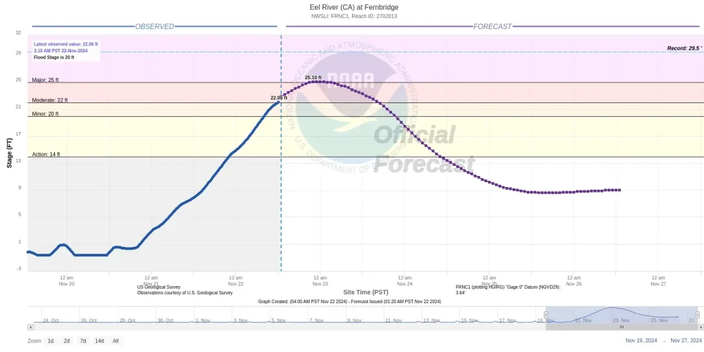
The Eel River at Fernbridge, California is forecast to reach a major flood stage on Friday, November 22, 2024, with floodwaters threatening Highway 211 and the Eel River delta.

Image credit: NOAA/GOES-East, Zoom Earth, The Watchers. Acquired at 08:20 UTC on November 22, 2024
The Eel River at Fernbridge is forecast to reach a major flood stage on Friday, November 22. Floodwaters were expected to impact Highway 211 leading to Ferndale starting Thursday night and continuing through Friday.
The National Weather Service (NWS) has issued a flood warning for the area, stating that the river is expected to rise to a crest of 7.65 meters (25.1 feet) Friday afternoon, exceeding the major flood stage threshold of 7.62 meters (25 feet).
This level of flooding could cause significant inundation in the Eel River Delta, including areas northwest of Loleta and the western portion of Cannibal Island Road. It may also result in multiple road closures in low-lying areas, such as Highway 211 to Ferndale.
According to the NWS, other rivers in the area are also expected to experience flooding. The Mad River in Arcata, the Van Duzen River at Bridgeville, the Navarro River at Navarro, and the Russian River at Hopland are forecast to see minor flooding.
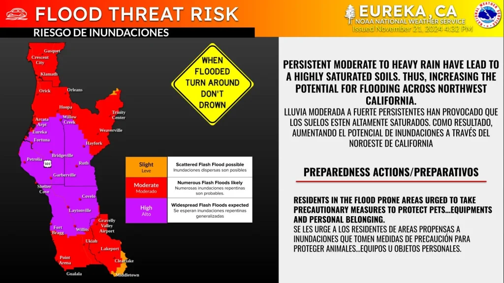
Parts of California are under a high “Flood Threat Risk” as continuing heavy rains have saturated the soil, creating significant flood concerns across northwestern California.

A Flood Advisory was issued at 22:45 local time (LT) on Thursday, with 25 – 76 mm (1 – 3 inches) of rainfall expected within six to eight hours of issuance. The advisory will remain in effect until 03:00 LT on Friday.
The flooding potential and rainfall are attributed to an ongoing atmospheric river event impacting northern California and southwestern Oregon, bringing heavy precipitation and strong winds to the region.
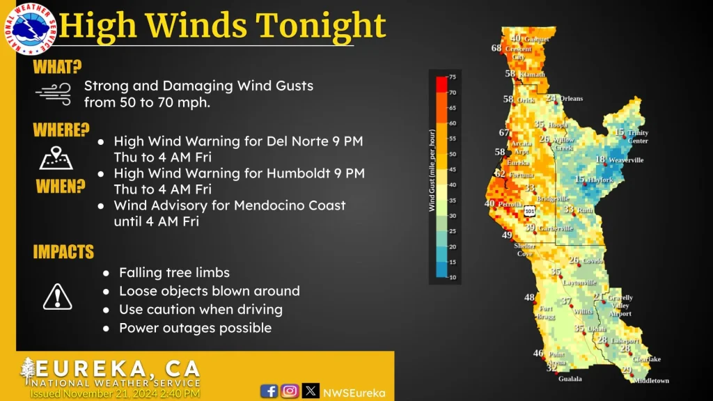
A High Wind warning has been issued for several parts of the affected regions, with gusts of 80 – 115 km/h (50 – 70 mph) expected in some areas through Friday. Damage due to falling tree limbs and power outages is anticipated.
The NWS has warned residents about dangerous travel conditions, urging them to avoid traveling unless necessary.

Anomalous moisture, supported by a deep low-pressure system, will continue impacting the Pacific Northwest today.
Life-threatening flooding is likely across portions of northern California, where additional rainfall of 76 – 127 mm (3 – 5 inches) is expected, mainly over coastal areas. Rainfall amounts of 102 – 254 mm (4 – 10 inches) are possible in the northern Sierra Nevada.
Dangerous flooding, rockslides, and debris flows remain likely today, NWS warns.
A Moderate Risk of Flash Flooding is in effect for upslope portions of the northern Sierra below 1 520 m (5 000 feet). The flooding risk is expected to decrease from north to south later today and into tonight.
Heavy mountain snow is forecast for the Washington Cascades and Northern Rockies through Saturday, November 23.
Multiple feet of snow are likely to accumulate over portions of the northern Sierra above 2 134 m (7 000 feet) by Saturday evening.
Strong winds will persist across coastal areas of northwest California, western Washington, and south-central Oregon. These winds may blow down trees and power lines, increasing the possibility of additional power outages.
As of 12:48 UTC (04:48 local time) on Friday, there are 12 320 customers still without power in Northern California. The worst affected is Mendocino County with 4 600 customers without power, followed by Humoldt with 3 770, and Trinity with 855.

I am an Assistant Editor and Severe Weather & Science Journalist at The Watchers, specializing in real-time severe weather coverage, geophysical event reporting, and research-driven scientific analysis. You can reach me at rishav(at)watchers(.)news.
Commenting rules and guidelines
We value the thoughts and opinions of our readers and welcome healthy discussions on our website. In order to maintain a respectful and positive community, we ask that all commenters follow these rules.