
Bomb cyclone set to explode off U.S. West Coast and Canada, bringing hurricane-force winds, heavy rain and mountain snow
A powerful Pacific low pressure system will impact the Northwest United States and Canada with strong winds, heavy rains and heavy mountain snow, starting Tuesday, November 19, 2024. The storm is expected to rapidly intensify as it approaches the coast.
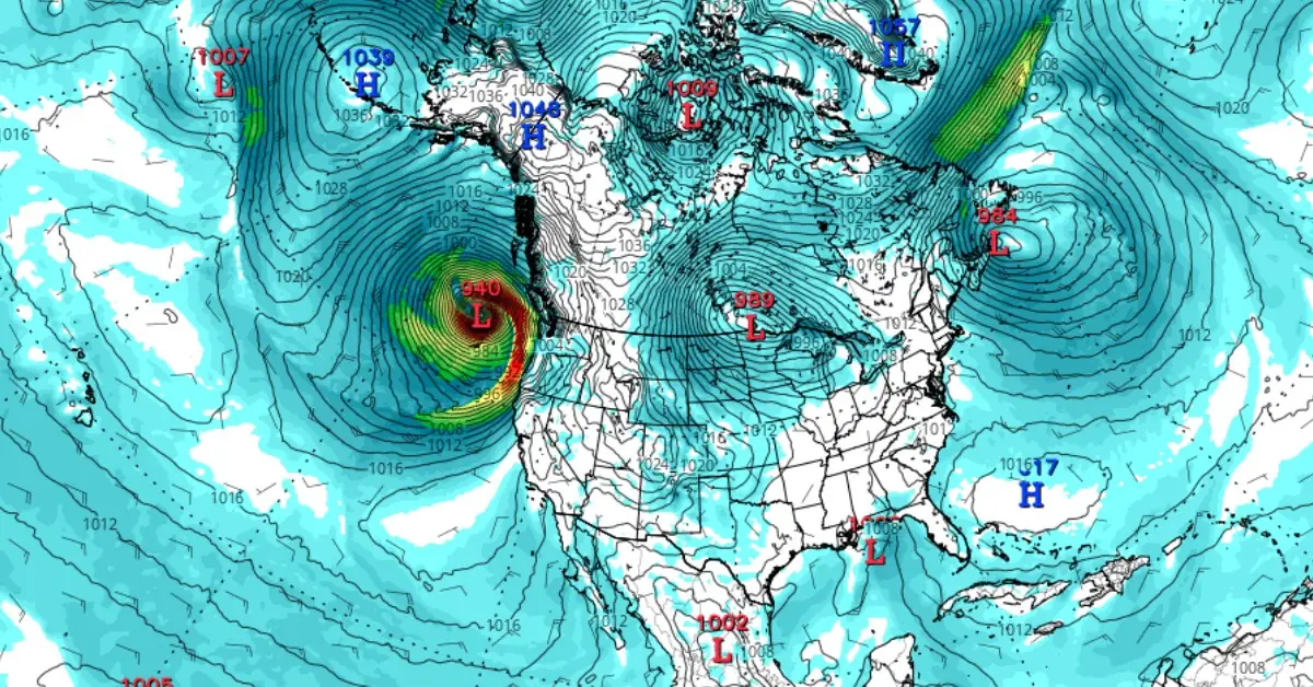
Image credit: GFS, Tropical Tidbits
- A low-pressure system over the North Pacific is expected to undergo rapid intensification (bombogenesis) as it approaches the U.S. West Coast on Tuesday, November 19, 2024.
- The system’s central pressure is predicted to drop from 1 004 hPa to 948 hPa within 24 hours, equivalent to a Category 4 hurricane.
- Parts of Oregon and Northern California could receive over 300 mm (12 inches) of rain from Tuesday through Thursday, increasing the risk of flash flooding and river overflow.
- The storm’s effects will extend to Canada, with British Columbia experiencing wind gusts of 90 – 100 km/h (56 – 62 mph) and rainfall exceeding 100 mm (3.9 inches) in some areas.
- The storm could lead to power outages, disrupted ferry services, and hazardous travel conditions across affected regions.
A powerful low-pressure system over the North Pacific is forecast to undergo rapid intensification (bomb cyclone) and impact the U.S. West Coast on Tuesday. This mid-latitude cyclone will align with a strong atmospheric river, delivering heavy rainfall to Oregon and California.
Bomb cyclone/bombogenesis refers to the rapid intensification of a low-pressure system within 24 hours, characterized by a pressure drop of at least 24 hPa, resulting in cyclone formation. The specific threshold for this process depends on the system’s latitude.
The system is expected to have a central pressure of approximately 1 004 hPa on Monday night before intensifying significantly. It will affect the western United States from Tuesday through Thursday, November 23. Forecast models predict a sharp pressure drop of 50 – 60 hPa within 24 hours, with the system reaching a minimum central pressure of 948 hPa by Tuesday evening, equivalent to a Category 4 hurricane.
“For much of the Northwest, northern Great Basin, and northern Rockies, a cold front pushing across the region today and enhanced onshore flow will allow for unsettled weather to continue ahead of a powerful storm system forecast to develop off the coast of the Northwest on Tuesday,” NWS forecaster Snell noted on November 18.
This appetizer of precipitation to start the workweek will mainly include the potential for moderate to heavy snowfall across the Cascades and northern Rockies, Snell said.
“However, by Tuesday night the rapidly strengthening Pacific low pressure system will aid in producing high winds across the Pacific Northwest and increasing precipitation intensity. Wind gusts up to 112 km/h (70 mph) are possible across parts of northern California and Oregon, with strong winds also expected over parts of western Washington.”
These winds will have the potential to knock down trees and produce power outages, Snell said.
Heavy snowfall with amounts potentially exceeding 60 cm (2 feet) are possible over the northern California ranges and Cascades.
By Wednesday, November 20, an associated atmospheric rive event is expected to take shape and direct continuous Pacific moisture toward northern California and southwest Oregon. Widespread rainfall amounts of 100 to 180 mm (4 to 7 inches) are expected through Wednesday across this region, which could produce areas of river flooding and increase the risk of mudslides.
“Heavy rain and the associated weather hazards from this atmospheric river event are also expected to continue beyond midweek,” Snell said.
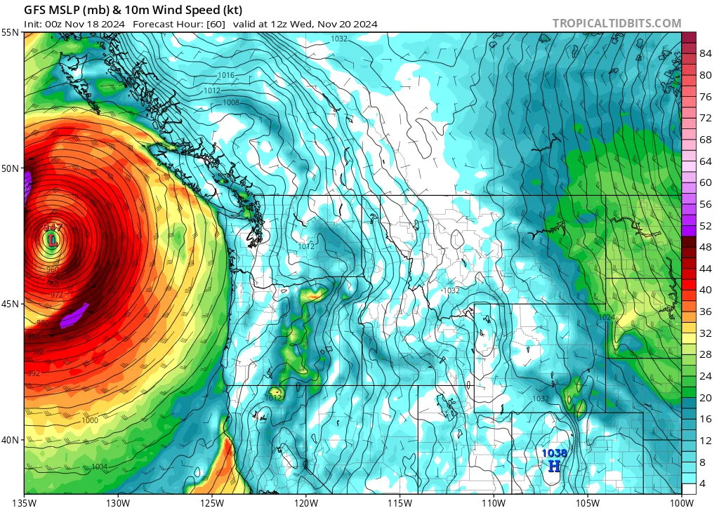
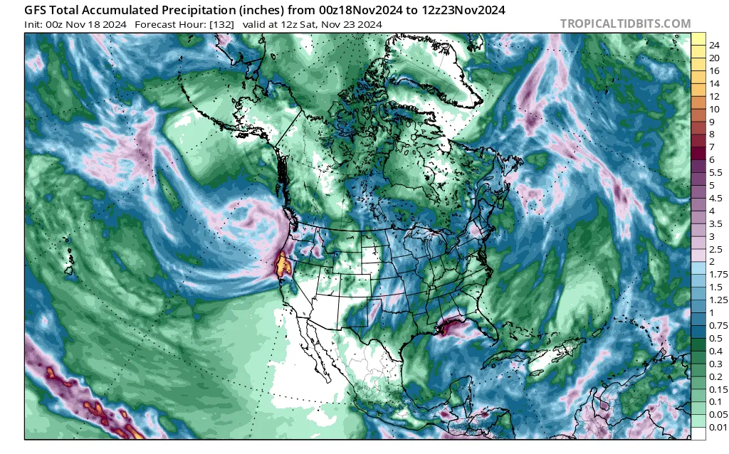
As this low-pressure system strengthens, it will draw in subtropical moisture, forming an atmospheric river. This phenomenon is expected to bring heavy rainfall, strong winds, and large ocean swells to the Northwest and Northern California.
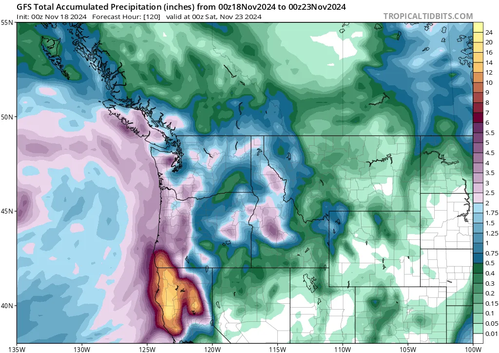
From Tuesday through Thursday, rainfall totals in parts of Oregon and Northern California are projected to exceed 300 mm (12 inches). These conditions could result in overflowing rivers and flash flooding in affected areas. The system could also produce waves of up to 21 m (70 feet) near the coast.
The system will bring strong sustained winds to California beginning Tuesday. Del Norte and Humboldt Counties are forecast to experience the strongest winds, ranging from 40 – 72 km/h (25 – 45 mph) with gusts of 96 – 112 km/h (60 – 70 mph). Higher gusts of up to 120 km/h (75 mph) are possible on elevated ridgetops.
A High Wind Watch has been issued for Del Norte and Humboldt from 16:00 local time (LT) on Tuesday to 10:00 LT on Wednesday, with the strong winds being expected to cause power outages and downed trees along with difficult driving conditions in the region.
The atmospheric river accompanying the bomb cyclone will bring heavy rains from Tuesday afternoon through the weekend over northwestern California. The heaviest rains are expected on Wednesday, November 22 with 50.8 to 101.6 mm (2 to 4 inches) of rain being expected. The rain is expected to persist and deliver 25.4 to 76.2 mm (1 to 3 inches) of precipitation being expected each day from Thursday through Saturday, November 23.
The impacts of this bomb cyclone will extend to parts of Canada, particularly British Columbia, during the first half of the week. Although the system is not expected to strike Canada directly, it will produce intense wind gusts and heavy precipitation from Tuesday through Wednesday. These conditions may result in power outages and disruptions to ferry services.
Light rain is expected to begin in parts of Canada on Tuesday, with heavy alpine snow developing as the system nears. Some regions could accumulate up to 100 cm (39.4 inches) of snow as freezing levels fall below 1 000 m (3 281 feet).
Winds associated with the system are forecast to intensify by Tuesday night, impacting the Strait of Georgia and Vancouver Island. Gusts of 90 – 100 km/h (56 – 62 mph) are expected, while the Lower Mainland may experience wind speeds of 50 – 70 km/h (31 – 43 mph). The strongest gusts are likely along western beaches.
Rainfall through Wednesday is projected to exceed 100 mm (3.9 inches) near Tofino and western Vancouver Island, with 30 – 50 mm (1.2 – 2 inches) forecast for the south coast. The Olympic Mountains will create a notable rain-shadow effect, leaving Victoria with less than 10 mm (0.4 inches) of precipitation.
Coastal communities may experience storm surges and flooding as the region exits the King Tide cycle on Tuesday and Wednesday. Elevated tides during the storm’s peak could result in coastal flooding near Victoria and Campbell River, especially on Wednesday morning.
References:
1 Short Range Forecast Discussion – NWS/WPC – November 18, 2024
2 Powerful bomb cyclone puts B.C. on notice for high impacts this week – The Weather Network – November 18, 2024
3 Bomb Cyclone Headed Toward the West Coast – Weather Nation – November 18, 2024

I am an Assistant Editor and Severe Weather & Science Journalist at The Watchers, specializing in real-time severe weather coverage, geophysical event reporting, and research-driven scientific analysis. You can reach me at rishav(at)watchers(.)news.

Commenting rules and guidelines
We value the thoughts and opinions of our readers and welcome healthy discussions on our website. In order to maintain a respectful and positive community, we ask that all commenters follow these rules.