
Central U.S. braces for intense weather system
Severe thunderstorms, heavy rain, and snowfall are forecast across the central United States as a deep low-pressure system strengthens on Monday, November 18, 2024, posing significant risks to parts of the Plains and Upper Midwest.

Deep low pressure system moving out of Texas. Image credit: GFS, Tropical Tidbits
- A deep low-pressure system moving out of West Texas is forecast to bring heavy rain, severe thunderstorms, and strong winds across the southern and central Plains starting Monday, November 18.
- Thunderstorms along an advancing cold front could produce damaging winds and isolated tornadoes, with the highest risk concentrated between central Oklahoma and North Texas.
- There’s a 70 – 90% chance of at least 10 cm (4 inches) of snow in north-central North Dakota.
- Heavy rainfall is expected to cause flash flooding, especially in low-lying and urban areas, with the heaviest rainfall on Monday night in eastern Louisiana and southern Mississippi.
A deep low-pressure system, currently moving out of West Texas, is forecast to intensify as it moves into the central United States on Monday. The system is expected to bring heavy rain, severe thunderstorms, and strong winds across the southern and central Plains.
Thunderstorms along an advancing cold front could produce damaging winds and possibly isolated tornadoes, particularly between central Oklahoma and North Texas. The Storm Prediction Center has issued a Slight Risk (Level 2 out of 5) for severe thunderstorms in this region on Monday.
Several tornado, thunderstorm, and severe weather warnings have been issued across the affected regions for Monday.
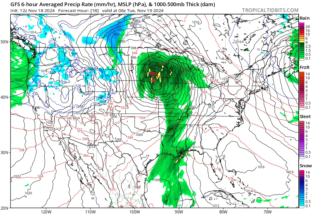
As the system moves northward, cold air on its western flank is likely to bring snowfall to parts of North Dakota and northern Minnesota between Tuesday and Wednesday, November 19 – 20.
Gusty winds may accompany the snow, potentially reducing visibility and creating hazardous travel conditions. Current forecasts indicate a 70 – 90% probability of at least 10 cm (4 inches) of snow in north-central North Dakota.
Further south, an influx of moisture from the Gulf of Mexico will interact with the system’s advancing cold front, resulting in widespread showers and thunderstorms.
Heavy rainfall is forecast to cause flash flooding in low-lying and urban areas. The heaviest rainfall on Monday night is expected across eastern Louisiana and southern Mississippi, with the risk extending to the Florida Panhandle by Tuesday.
Scattered flash floods are most likely in areas vulnerable to water accumulation, such as low-lying and urban regions.
References:
1 Short Range Public Discussion – WPC – November 18, 2024

I am an Assistant Editor and Severe Weather & Science Journalist at The Watchers, specializing in real-time severe weather coverage, geophysical event reporting, and research-driven scientific analysis. You can reach me at rishav(at)watchers(.)news.
Commenting rules and guidelines
We value the thoughts and opinions of our readers and welcome healthy discussions on our website. In order to maintain a respectful and positive community, we ask that all commenters follow these rules.