
Remnants of Super Typhoon “Kong-rey” bring record rains to China, risk of landslides and severe flooding in Japan
Former Super Typhoon “Kong-rey” brought record-breaking rainfall to coastal China after causing significant destruction in Taiwan, where it left 3 people dead and over 500 injured. What’s left of this storm is now moving toward Japan, with western regions already experiencing its effects, expected to last into November 2. Eastern Japan and the Tohoku region are likely to be impacted from November 2 to 3, with risks of landslides, flooding in low-lying areas, and rising river levels.

Remnants of Super Typhoon "Kong-rey" bring heavy rain to South Korea and Japan. Credit: JMA/Himwari-9, Zoom Earth, The Watchers. Acquired at 17:30 UTC on November 1, 2024
Influenced by the extratropical cyclone that evolved from the remnants of former Super Typhoon “Kong-Rey”, along with a front and newly forming low-pressure systems, eastern and western Japan are bracing for extremely heavy rain and thunderstorms from November 1 to November 4.
Heavy rainfall accompanied by thunder is forecast for western Japan from November 1 to November 2, while similar conditions are anticipated in eastern Japan and the Tohoku region from November 3 to November 4.
The Japan Meteorological Agency (JMA) warned, urging residents to prepare for potential rain-related disasters, flooding in low-lying areas, and river overflows.

According to the JMA, northern Kyushu could receive up to 250 mm (9.84 inches) of rainfall within a 24-hour period by 12:00 local time (LT) on November 2. Southern Kyushu and the Chugoku region are forecast to receive 150 mm (5.91 inches), while other regions are expected to receive 50 – 100 mm (1.97 – 3.94 inches) during this same period.
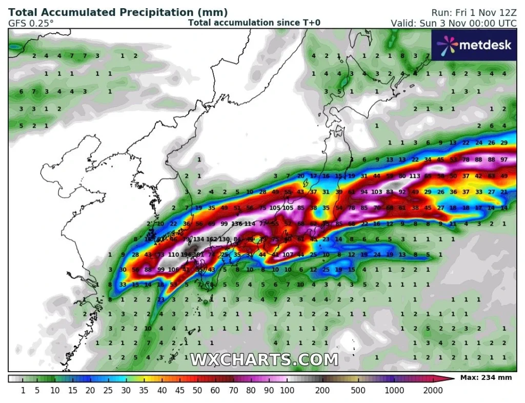
By 12:00 LT on November 3, a 24-hour rainfall of 150 mm (5.91 inches) is forecast for the Tokai, Kinki, Shikoku, and northern Kyushu regions, with 60 – 100 mm (2.36 – 3.94 inches) expected for other areas.
Typhoon “Kong-rey” peaked as a Category 4-equivalent super typhoon on October 30, reaching one-minute sustained winds of 240 km/h (150 mph) before making landfall in Taiwan on October 31, where it began to weaken.
In Taiwan, Kong-rey killed three people and injured at least 515, with four others reported missing. Major rainfall included 119.5 mm (4.70 inches) in an hour in Hualien and over 300 mm (12 inches) within 24 hours in Hualien City and Zhuoxi.
The storm caused widespread disruptions, including power outages affecting 843 000 homes, water shortages for over 33 000 households, and 108 flooded areas. Landslides, mudslides, and blocked roads were reported, alongside NT$277.39 million (US$8.86 million) in agricultural and facility losses. The cargo vessel Yu Zhou Qi Hang also ran aground, sparking fears of an oil spill.
The system then reemerged over the Taiwan Strait with a weakened convective structure. It moved along the eastern coast of China, interacting with a strong frontal system, and began its extratropical transition, fully transitioning into an extratropical low by 12:00 UTC on November 1.
After making landfall in eastern China, the system brought heavy rains and strong winds to Zhejiang and Fujian provinces.
In Zhejiang, 80 stations broke rainfall records for November, with nine stations setting records for the entire month within just one day.
Linhai station in Zhejiang recorded 216.3 mm (8.5 inches) of rainfall on November 1, surpassing the previous monthly rain record of 193.5 mm (7.6 inches), set in 1997.
Pudong Huinan station in Shanghai also broke its monthly rainfall record of 173.8 mm (6.8 inches) for November, set in 2006, after recording 242.8 mm (9.6 inches) of rain on November 1.
The effects of the storm resulted in the heaviest November rainstorm for Shanghai on November 1 with the city recording 252 mm (9.9 inches) of rainfall in one day with the urban areas receiving 172 mm (6.7 inches) of rain due to the storm.
Several other stations across Shanghai and Zhejiang provinces reported record-breaking rainfall. Qidong station in Jiangsu province recorded 146.2 mm (5.8 inches) of rain on November 1, breaking the previous November record of 139.8 mm (5.5 inches), set in 2006.
In Hallasan, South Korea’s Jeju Island, up to 268.5 mm (10.57 inches) of rain was recorded on November 1, resulting in flooding which caused damage to buildings across the island.
References:
1 RSMC TROPICAL CYCLONE PROGNOSTIC REASONING – JMA – November 1, 2024
2 RSMC TROPICAL CYCLONE ADVISORY – JMA -November 1, 2024
3 Current Maximum Hourly Precipitation by District – CWA – October 31, 2024
4 Kong-rey among biggest typhoons to hit Taiwan in decades – France 24 – October 31, 2024
5 台风“康妮”已造成台湾3人死亡 – The Paper – November 1, 2024

I am an Assistant Editor and Severe Weather & Science Journalist at The Watchers, specializing in real-time severe weather coverage, geophysical event reporting, and research-driven scientific analysis. You can reach me at rishav(at)watchers(.)news.
Commenting rules and guidelines
We value the thoughts and opinions of our readers and welcome healthy discussions on our website. In order to maintain a respectful and positive community, we ask that all commenters follow these rules.