
Oscar makes landfall in Guantanamo as a Category 1 hurricane, Cuba
Category 1 Hurricane “Oscar” made landfall on the northern coast of eastern Cuba at around 21:50 UTC on Sunday, October 20, 2024. Tropical storm conditions are forecast to persist in eastern Cuba on Monday and are expected to affect the southeastern Bahamas tonight (LT) and Tuesday.

Satellite image of Hurricane "Oscar" at 21:30 UTC on October 20, 2024. Credit: NOAA/GOES-East, Zoom Earth, The Watchers
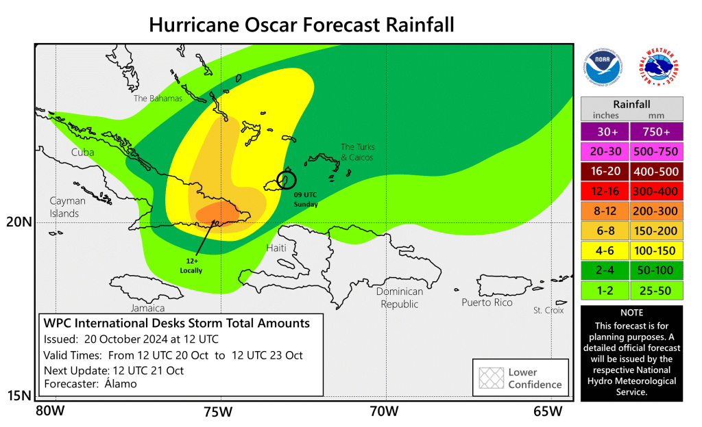
- Through midweek, heavy rainfall from Oscar will lead to areas of significant, life-threatening flash flooding along with mudslides across portions of eastern Cuba, especially within the Sierra Maestra.
- Localized flash flooding will be possible across the southeastern Bahamas.
- Tropical storm conditions are expected to continue today across portions of eastern Cuba.
- Tropical storm conditions are also expected in portions of the southeastern Bahamas tonight and Tuesday.
Hurricane “Oscar” made landfall in the Cuban province of Guantánamo at around 21:50 UTC on Sunday, October 20. Maximum sustained winds at the time of landfall were recorded at 129 km/h (80 mph), with a minimum central pressure of 986 hPa.
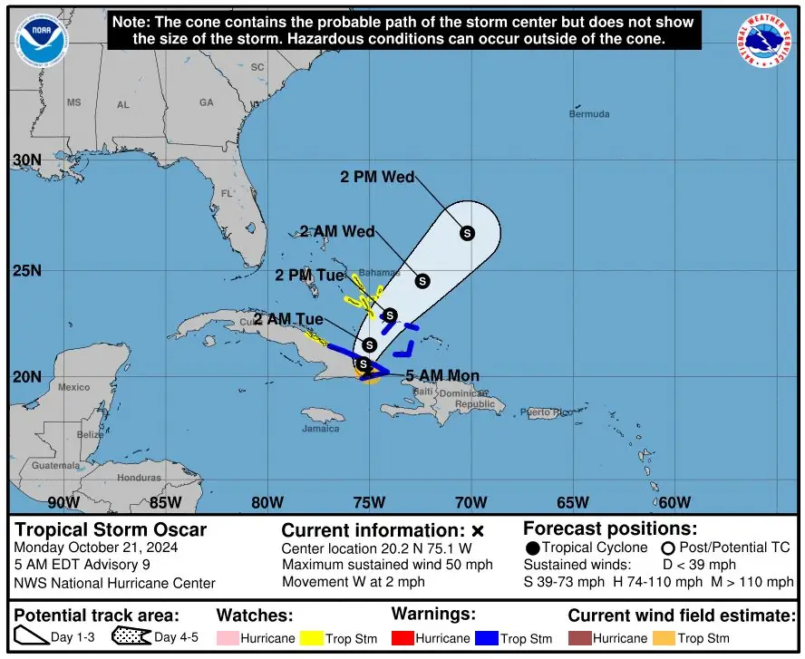
Oscar weakened into a tropical storm after landfall, with wind speeds dropping to 97 km/h (60 mph). As of 06:00 UTC on Monday, October 21, the storm was located around 32 km (20 miles) east of Guantánamo, moving west-southwest at 8 km/h (5 mph) with a minimum central pressure of 996 hPa.
The slow-moving storm is producing heavy rain and life-threatening flash floods across eastern Cuba. Rainfall of 150 – 300 mm (6 – 12 inches) is expected, with isolated amounts of up to 450 mm (18 inches), through Wednesday morning, October 23.
Tropical Storm Warnings are in effect for the provinces of Las Tunas, Holguín, and Guantánamo up to Punta Maisí. The southern coast of Cuba and the southeastern Bahamas are also under warning.
A Tropical Storm Watch is in effect for the central Bahamas and the north coast of Camagüey province in Cuba.

Tropical storm conditions are expected in the warning area and possibly in the watch area of Cuba on Monday. Tropical storm conditions are also expected in the warning area in parts of the southeastern Bahamas and possibly in the watch area in parts of the central Bahamas from today into Tuesday.
Rainfall of 75 – 125 mm (3 – 5 inches) is expected across the southeastern Bahamas, with isolated totals of up to 200 mm (8 inches) in some areas. Turks and Caicos can expect 50 – 100 mm (2 – 4 inches) of rainfall through Wednesday morning.
Water levels of 0.3 – 0.9 m (1 – 3 feet) above normal tide levels are expected along the north shore of Cuba in areas experiencing onshore winds. Near the coast, the surge will be accompanied by large and destructive waves.
The storm is forecast to turn west and northwest on Monday, followed by a faster northeastward movement through Tuesday, October 22, and Wednesday.
Oscar is expected to move across eastern Cuba through Monday afternoon, emerging off the northern coast later the same day, before moving near the southeastern and central Bahamas on Tuesday.
At 09:00 UTC on October 21, Oscar’s maximum sustained winds were 85 km/h (50 mph). The storm was moving west at 4 km/h (2 mph) and had a minimum central pressure of 999 hPa.
References:
1 Tropical Storm Oscar Intermediate Advisory Number 8A –NHC – Released at 06:00 UTC on October 21, 2024
2 Hurricane Oscar Tropical Cyclone Update – NHC – Released at 21:50 UTC, October 20, 2024

I am an Assistant Editor and Severe Weather & Science Journalist at The Watchers, specializing in real-time severe weather coverage, geophysical event reporting, and research-driven scientific analysis. You can reach me at rishav(at)watchers(.)news.
Commenting rules and guidelines
We value the thoughts and opinions of our readers and welcome healthy discussions on our website. In order to maintain a respectful and positive community, we ask that all commenters follow these rules.