
Record-breaking temperatures in the West, heavy rains with flash flooding along the Gulf Coast, U.S.
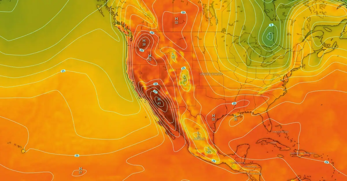
Featured image: Temperature forecast for September 7, 2024. Credit: Windy, ECMWF, The Watchers
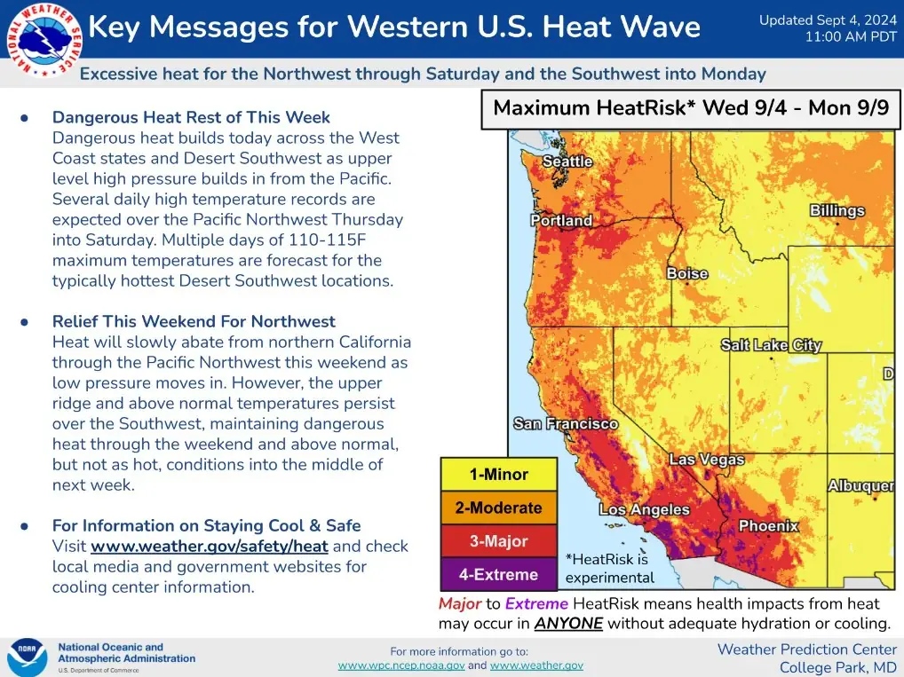
A dangerous heatwave is set to intensify across the Southwest and Western Coast of the United States starting September 5, 2024, with forecasts predicting temperatures soaring as high as 48.9 °C (115 °F) in some areas. The National Weather Service (NWS) has issued multiple warnings for heat-related illnesses as record-breaking highs are expected in the Pacific Northwest. Meanwhile, heavy rain and flash flooding remain in the forecast along the Gulf Coast.
According to the National Weather Service, a dangerous heatwave will intensify over the Southwest and Western Coast of the United States starting on September 5.
With a strong upper-level ridge now settled over the region, forecast high temperatures on Thursday and Friday range from 43 – 46 °C (110 – 115 °F) for the Desert Southwest, 37 – 43 °C (100 – 110 °F) for southern California, 38 – 43 °C (100 – 110 °F) for the central California Valleys, and 32 – 38 °C (90 – 100 °F) for central/northern California and into the Pacific Northwest.
High temperatures ranging from 43.3 °C – 48.9 °C (110 °F – 115 °F) are forecast for the Desert Southwest and low 37.8 °C – 43.3 °C (100 °F – 110 °F) for Southern California. The hottest desert locations in the Southwest will experience multiple days of temperatures between 43.3 °C – 46.1 °C (110 °F – 115 °F).
There is a possibility that the Pacific Northwest will experience several record-breaking highs between September 5 and 7.
Multiple heat-related warnings and advisories have been issued due to the risk of heat-related illnesses.
The heat will weaken into the weekend as low pressure moves over the Pacific Northwest and Northern California. However, the upper-level ridge and high temperatures will persist in the Southwest, maintaining above-normal but still dangerous temperatures into the following week.
Meanwhile, heavy rain and flash flooding remain in the forecast along the Gulf Coast as a stationary front and coastal low pressure system drive multiple days of widespread showers and thunderstorms across the region.
The elongated area of low pressure and front from the north-central to western Gulf will keep the greatest focus on repeated rounds of storms moving onshore over the central Gulf Coast and upper Texas Gulf Coast today, September 5, with the potential to spread further northward into the Lower Mississippi Valley.
Very moist Gulf air continues to contribute to intense downpours with these storms, with rainfall rates approaching 50 – 75 mm (2 – 3 inches) per hour in some cases, exacerbating the threat of heavy rainfall totals and flash flooding.
There is now a Moderate Risk (level 3/4) of Excessive Rainfall for southeastern Louisiana, where prior days’ rainfall has led to very wet antecedent conditions, bringing a locally greater threat of scattered to numerous instances of flash flooding, particularly in urban areas around greater New Orleans.
References:
1 Short Range Public Discussion – WPC – Released on September 5, 2024

I am an Assistant Editor and Severe Weather & Science Journalist at The Watchers, specializing in real-time severe weather coverage, geophysical event reporting, and research-driven scientific analysis. You can reach me at rishav(at)watchers(.)news.
Commenting rules and guidelines
We value the thoughts and opinions of our readers and welcome healthy discussions on our website. In order to maintain a respectful and positive community, we ask that all commenters follow these rules.