
Hurricane Watch issued for portions of west-central Florida and the Big Bend region
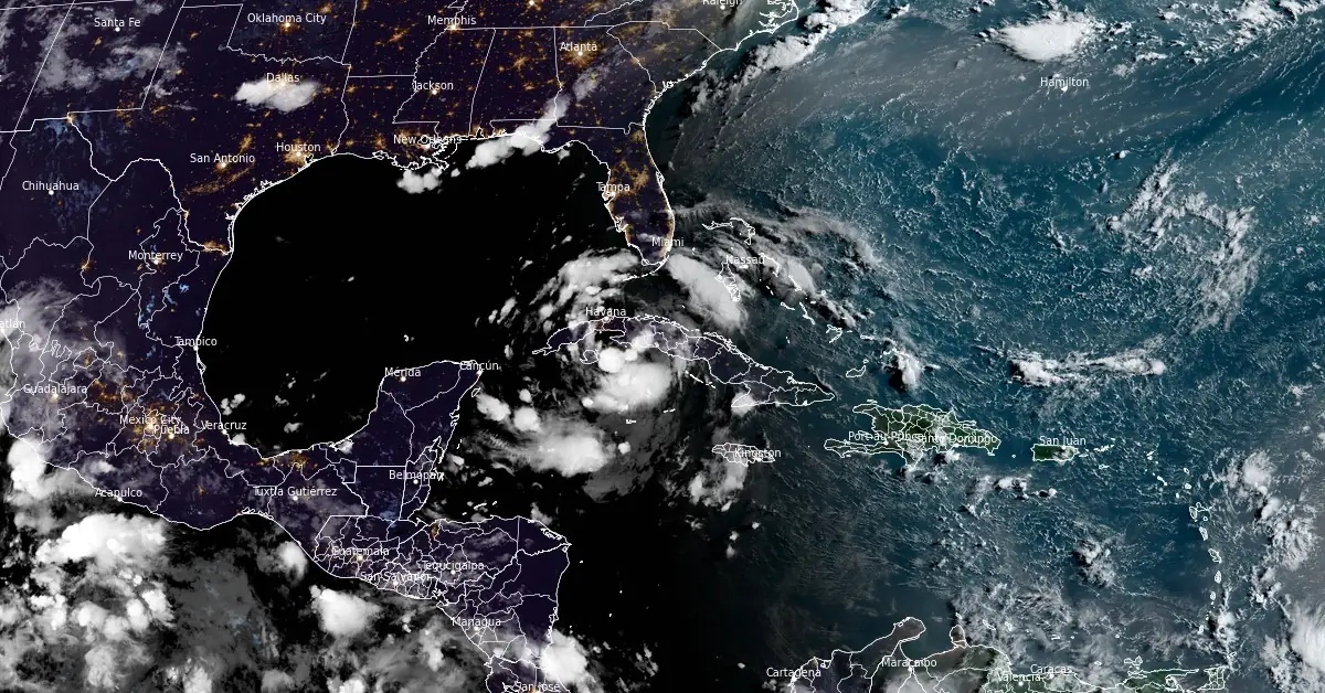
Image credit: NOAA/GOES-East, RAMMB/CIRA, The Watchers. Acquired at 11:30 UTC on August 3, 2024
Tropical Depression Four is expected to strengthen into a tropical storm as it tracks west of the Florida Peninsula this weekend and impact Florida this weekend by bringing hazardous rainfall and flooding, gusty winds, life-threatening inundation from storm surge along portions of the west coast, and the threat of a few tornadoes.
- Heavy rainfall may result in locally considerable flash and urban flooding across portions of Florida and the coastal areas of the Southeast U.S. this weekend through Wednesday. Isolated river flooding will also be possible.
- A Hurricane Watch has been issued for portions of west-central Florida and the Big Bend region, where hurricane conditions are possible late Sunday, August 4. Tropical storm conditions are expected farther south along Florida’s west coast, including the Tampa Bay area, and across the Dry Tortugas where Tropical Storm Warnings are in effect.
- There is a possibility of life-threatening inundation from storm surge along portions of the west coast of Florida from Bonita Beach to Aucilla River, including Tampa Bay and Charlotte Harbor, where a Storm Surge Watch is in effect.
- Impacts from storm surge, strong winds, and heavy rains are possible elsewhere in Florida and along the southeast coast of the United States from Georgia to North Carolina through the middle of next week, and interests in those areas should continue to monitor the progress of this system. Additional watches and warnings will likely be required later today.
Heavy rainfall, strong winds, and life-threatening storm surge inundation are all possible along the western coast of the state beginning today, August 3. Heavy rainfall, strong winds and storm surge are also possible over northern Florida and the Southeast U.S. Coast Sunday evening into early next week. Tropical Storm Warnings and Storm Surge Watches are in effect along Florida’s Gulf Coast while Tropical Storm Watches extend farther out across the other Gulf Coast states.
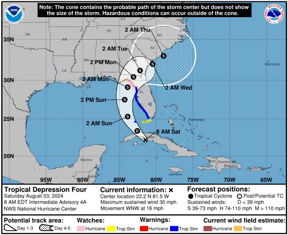
At 12:00 UTC on August 3, the center of Tropical Depression Four was located about 120 km (75 miles) S of Varadero, Cuba and 275 km (170 miles) S of Key West, Florida. The system had a minimum central pressure of 1 009 hPa, maximum sustained winds of 45 km/h (30 mph), and was moving WNW at 25 km/h (16 mph).
A turn toward the northwest is forecast today, followed by a northward motion on Sunday, August 4 and then a slower northeastward motion Sunday night and Monday.
#Hurricane watches have been issued for parts of the Florida Gulf Coast due to Tropical Depression Four. Three #hurricanes have made landfall in Florida in August since 2000: Charley (2004), Katrina (2005) and Idalia (2023). pic.twitter.com/GkgFr5pHCY
— Philip Klotzbach (@philklotzbach) August 3, 2024
On the forecast track, the center of the depression will move across western Cuba this morning, and then move over the eastern Gulf of Mexico later today and Sunday, reaching the Florida Gulf coast late Sunday or Monday.
Strengthening is forecast during the next couple of days, and the depression is expected to become a tropical storm (next name is Debby) later today and continue strengthening over the eastern Gulf of Mexico through the weekend.
The combination of storm surge and tide will cause normally dry areas near the coast to be flooded by rising waters moving inland from the shoreline.
The water could reach the following heights above ground in the indicated areas if the peak surge occurs at the time of high tide:
- Chassahowitzka, FL to Aucilla River, FL: 0.91 – 1.52 m (3 – 5 feet)
- Bonita Beach, FL to Chassahowitzka, FL: 0.61 – 1.22 m (2 – 4 feet)
- Tampa Bay: 0.61 – 1.22 m (2 – 4 feet)
- Charlotte Harbor: 0.61 – 1.22 m (2 – 4 feet)
The system is expected to produce rainfall totals of 127 – 254 mm (5 – 10 inches), with maximum rainfall totals up to 381 mm (15 inches), across portions of Florida and along the Southeast U.S. coast this weekend through Thursday morning. This rainfall may result in areas of locally considerable flash and urban flooding, with isolated river flooding possible.
For Cuba, rainfall amounts of 25 – 51 mm (1 – 2 inches), with localized higher amounts, will be possible through today. This may result in isolated to scattered areas of flooding.
A tornado or two is possible across the Florida Keys and the western Florida Peninsula tonight through Sunday morning.
On August 1, Florida Governor Ron DeSantis declared a state of emergency for 54 counties ahead of any potential areas the storm might impact.
Floridians are encouraged to monitor weather conditions, listen to all orders from local officials, create disaster preparedness plans, and stock disaster supply kits with food, water, and other necessities for their households.
References:
1 Tropical Depression Four – Intermediate Advisory Number 4A – NWS/NHC – 800 AM EDT Sat Aug 03 2024
2 Governor DeSantis Issues Updates on State Preparations Ahead of Severe Weather and Urges Floridians to Prepare – FLGOV – August 2, 2024
I'm a dedicated researcher, journalist, and editor at The Watchers. With over 20 years of experience in the media industry, I specialize in hard science news, focusing on extreme weather, seismic and volcanic activity, space weather, and astronomy, including near-Earth objects and planetary defense strategies. You can reach me at teo /at/ watchers.news.
Commenting rules and guidelines
We value the thoughts and opinions of our readers and welcome healthy discussions on our website. In order to maintain a respectful and positive community, we ask that all commenters follow these rules.