
Category 3 Hurricane “Norma” expected to approach Baja California Sur tonight
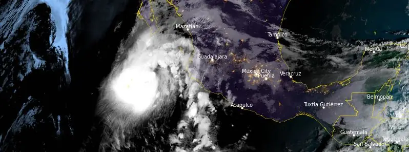
Featured image: Hurricane "Norma" at 12:50 UTC on October 20, 2023. Credit: NOAA/GOES-East, RAMMB/CIRA, The Watchers
Hurricane “Norma” is expected to approach the southern portion of Baja California Sur tonight, causing severe weather conditions including heavy rainfall and flash flooding.
- A Hurricane Warning is in effect for the far southern portion of the Baja California peninsula, where Norma is expected to bring hurricane conditions on Saturday when it passes near or over the area. Tropical storm conditions are also expected within the tropical storm warning areas in Baja California Sur on Saturday.
- Heavy rains from Norma will begin to impact the far southern portions of California Baja Sur later today, continuing through Sunday. This rainfall may produce flash and urban flooding, along with possible mudslides in areas of higher terrain.
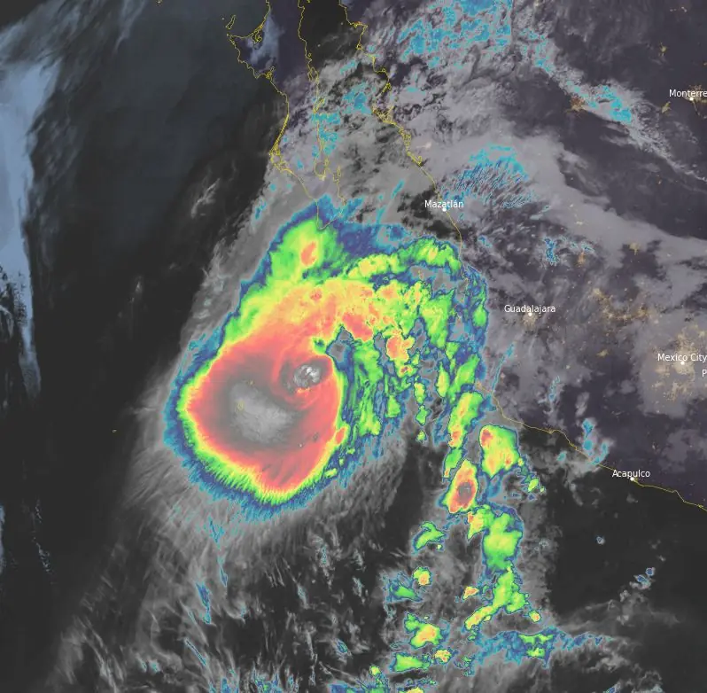
At 12:00 UTC on October 20, 2023, the center of Hurricane “Norma” was located about 425 km (265 miles) SSE of Cabo San Lucas and 485 km (300 miles) W of Manzanillo, Mexico.
The system had maximum sustained winds of 185 km/h (115 mph) and a minimum central pressure of 958 hPa.
Norma is moving toward the north-northwest near 11 km/h (7 mph). A slower north-northwestward to northward motion is forecast through Saturday, October 21, followed by a turn toward the north-northeast or northeast on Sunday.
On the forecast track, Norma is forecast to approach the southern portion of Baja California Sur tonight and Saturday.
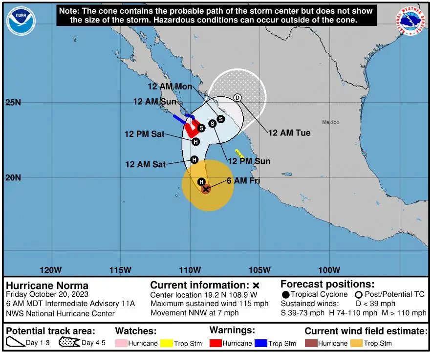
A Hurricane Warning has been issued for Baja California Sur from Todos Santos to Los Barriles, while a Tropical Storm Warning is in effect for areas north of Los Barriles to La Paz and north of Todos Santos to Santa Fe. Additionally, a Tropical Storm Watch has been issued for Las Islas Marias.
The hurricane is expected to bring heavy rains, with rainfall totals projected to be between 125 to 250 mm (5 and 10 inches), and local maxima reaching up to 380 mm (15 inches) through Sunday across the far southern part of California Baja Sur. This is highly likely to result in flash and urban flooding, along with the possibility of mudslides in areas of higher terrain.
The area of hurricane-force winds extends outward up to 45 km (30 miles) from the storm’s center, while tropical-storm-force winds extend outward up to 240 km (150 miles). These conditions are expected to reach the warning areas by tonight or early Saturday.
A storm surge could produce coastal flooding in areas of onshore winds within the hurricane warning area. These conditions are likely to be accompanied by large and destructive waves. Swells generated by Hurricane “Norma” are currently affecting parts of the coast of southwestern Mexico and Baja California Sur and will spread northward along the coast during the next couple of days.
Residents and interests in Baja California Sur and along the west coast of mainland Mexico are advised to monitor the progress of Norma closely, as additional watches or warnings may be issued. The National Weather Service recommends that preparations to protect life and property should be rushed to completion.
References:
1 Hurricane Norma – Intermediate Advisory Number 11A – NWS National Hurricane Center Miami FL EP172023 – 600 AM MDT Fri Oct 20 2023
I'm a dedicated researcher, journalist, and editor at The Watchers. With over 20 years of experience in the media industry, I specialize in hard science news, focusing on extreme weather, seismic and volcanic activity, space weather, and astronomy, including near-Earth objects and planetary defense strategies. You can reach me at teo /at/ watchers.news.
Commenting rules and guidelines
We value the thoughts and opinions of our readers and welcome healthy discussions on our website. In order to maintain a respectful and positive community, we ask that all commenters follow these rules.