
Earthquake swarm in the Reykjanes/Svartsengi volcanic system, Aviation Color Code raised to Yellow, Iceland
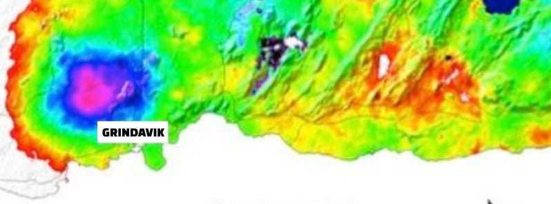
Image credit: IMO
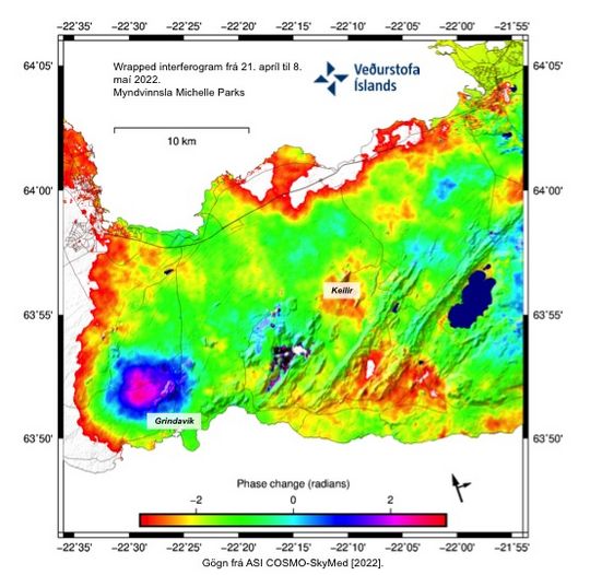
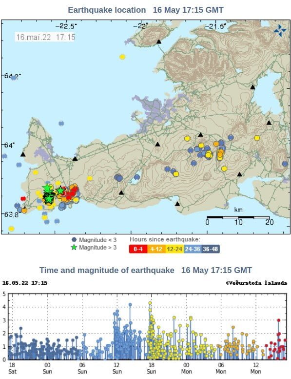
More than 3 000 earthquakes have been detected near Eldvörp in the Reykjanes/Svartsengi volcanic system in the past week. In addition, recent deformation observations identified the onset of a new inflation event west of Thorbjörn which is likely caused by magma intrusion.
Since Sunday, May 15, 2022, 9 earthquakes had magnitude above M3 and two above M4. The largest event was M4.3 at 17:38 UTC.1
The seismicity is located at a depth between 4 and 6 km (2.5 – 3.7 miles).
The Icelandic Met Office (IMO) specialists said landslides can occur on slopes and mountain sides when earthquakes of these magnitudes occur.
Caution is advised for people in those areas.
Recent deformation observations (both cGPS and InSAR) identified the onset of a new inflation event west of Thorbjörn likely caused by magma intrusion. Preliminary modeling results indicate the source is located at a depth between 4 – 5 km (2.5 – 3.1 miles).
In light of the increased seismic activity and the ongoing deformation in the Reykjanes/Svartsengi volcanic system, the Aviation Color Code was raised from Green to Yellow.
Additionally, the Civil Protection Department of Iceland elevated its alert level to Uncertainty level.
Geological summary
The Reykjanes volcanic system at the SW tip of the Reykjanes Peninsula, where the Mid-Atlantic Ridge rises above sea level, comprises a broad area of postglacial basaltic crater rows and small shield volcanoes.
The submarine Reykjaneshryggur volcanic system is contiguous with and is considered part of the Reykjanes volcanic system, which is the westernmost of a series of four closely-spaced en-echelon fissure systems that extend diagonally across the Reykjanes Peninsula.
Most of the subaerial part of the system (also known as the Reykjanes/Svartsengi volcanic system) is covered by Holocene lavas.
Subaerial eruptions have occurred in historical time during the 13th century at several locations on the NE-SW-trending fissure system, and numerous submarine eruptions dating back to the 12th century have been observed during historical time, some of which have formed ephemeral islands.
Basaltic rocks of probable Holocene age have been recovered during dredging operations, and tephra deposits from earlier Holocene eruptions are preserved on the nearby Reykjanes Peninsula.
This volcano is located within the Reykjanes, a UNESCO Global Geopark property.2
References:
1 Earthquakes on the Reykjanes peninsula – IMO – May 16, 2022
2 Reykjanes – Geological summary – GVP
I'm a dedicated researcher, journalist, and editor at The Watchers. With over 20 years of experience in the media industry, I specialize in hard science news, focusing on extreme weather, seismic and volcanic activity, space weather, and astronomy, including near-Earth objects and planetary defense strategies. You can reach me at teo /at/ watchers.news.
Commenting rules and guidelines
We value the thoughts and opinions of our readers and welcome healthy discussions on our website. In order to maintain a respectful and positive community, we ask that all commenters follow these rules.