
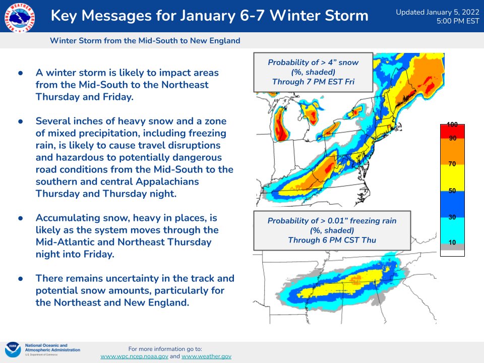
Winter storm to impact areas from Mid-South to New England with heavy snow and freezing rain, U.S.
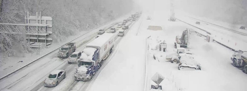
Image credit: VDOT Fredericksburg
Another winter storm is expected to impact areas from the Mid-South to the central and southern Appalachians on Thursday into Thursday night, January 6, 2022, before tracking along the Northeast coast on Friday.
- Several inches of heavy snow and a zone of mixed precipitation, including freezing rain, is likely to cause travel disruptions and hazardous to potentially dangerous road conditions from the Mid-South to the southern and central Appalachians on Thursday and Thursday night, NWS Weather Prediction Center warns.
- Accumulating snow, heavy in places, is likely as the system moves through the Mid-Atlantic and Northeast Thursday night into Friday, January 7.
- There remains uncertainty in the track and potential snow amounts, particularly for the Northeast and New England.
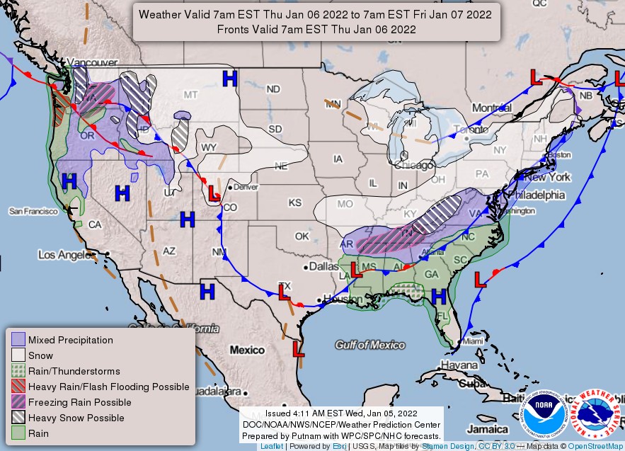
A wave of low pressure is forecast to develop along an arctic front draped across the Deep South by Thursday, January 6, NWS forecaster Santorelli noted.1
Moderate snowfall is possible to the north of the front from Kansas into Missouri where at least a couple of inches of snow is forecast.
As the low tracks through the Southeast on Thursday, heavy snowfall is expected to develop across parts of the Tennessee Valley into the central Appalachians, with some ice farther to the south across southern/eastern Tennessee and northern Mississippi and Alabama.
The combination of snow and ice may cause hazardous road conditions through Thursday night in this region.
As the low moves off the Mid-Atlantic coast and rapidly deepens offshore, accumulating snow will also spread into the Mid-Atlantic and the Northeast, where a few inches are possible.
Higher amounts may be realized across especially eastern portions of New England, but exact amounts remain uncertain and highly dependent on the exact track of the low off the coast.
This is the second winter storm to hit the region this week.2
On Monday and Tuesday, January 3 and 4, a quick-hitting winter storm impacted areas from the Southeast to the Mid-Atlantic, leaving nearly 1 million customers without power and at least 5 people dead. Thousands of flights have been grounded and hundreds of drivers stranded on I-95 in Virginia.3
The worst affected was Virginia where at least 450 000 customers were affected at the height of the storm.
By 09:36 UTC on January 5, 214 000 customers there were still without power and 132 000 by 22:47 UTC.
References:
1 Short Range Forecast Discussion – NWS Weather Prediction Center College Park MD – 342 PM EST Wed Jan 05 2022
2 Quick-hitting Southeast to Mid-Atlantic winter storm, nearly 1 million customers without power – The Watchers
3 Hundreds of drivers stranded on Interstate-95 after major snowstorm hits U.S. – The Watchers
I'm a dedicated researcher, journalist, and editor at The Watchers. With over 20 years of experience in the media industry, I specialize in hard science news, focusing on extreme weather, seismic and volcanic activity, space weather, and astronomy, including near-Earth objects and planetary defense strategies. You can reach me at teo /at/ watchers.news.
I love snow. The more the merrier. There is almost never enough snow. Safe to drive in.
I hate freezing rain and ice. Dangerous to drive in.