
Heavy rain and widespread damaging winds expected across parts of Western Australia
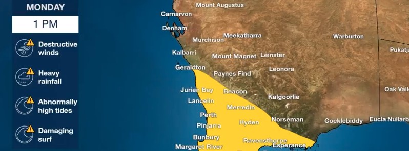
Image credit: BOM Australia
The latest in a month-long series of cold fronts to arrive in southwest Western Australia will bring a range of severe weather to the most populated regions within the state starting Monday, July 26, 2021. This front is expected to be windier than a typical front and is likely to produce the kind of weather that is only seen around twice a year.
"The first thing people will notice is intense rain with the potential to cause flash flooding in metro areas between Perth and Bunbury and inland across the Darling Scarp from late Monday afternoon," the Australian Bureau of Meteorology said.
This rain is also expected to fall over already saturated river catchments and result in additional inflow into swollen river systems.
Widespread rainfall totals over the two days of 10 – 20 mm (0.4 – 0.8 inches) are likely to occur southwest of Jurien Bay to Esperance.
The heaviest falls of 30 – 60 mm (1.2 – 2.4 inches) are likely to occur between Perth and Busselton extending inland across the Great Southern.
Widespread damaging winds averaging 60 – 70 km/h (37 – 43 mph) with gusts to 120 km/h (75 mph) are likely to develop southwest of Bunbury to Bremer Bay from early Monday afternoon (LT) extending to the southwest of Jurien Bay to Bremer Bay, including the Perth metro area from mid to late afternoon.
Isolated gusts in excess of 125 km/h (80 mph) are possible southwest of a line from Geraldton to Bremer Bay and may develop from the mid-Monday afternoon and continue through the evening.
Dangerous surf conditions will develop again from tonight for a large part of the West Australian coastline with large swells continuing for the rest of the week. Total wave heights may reach up to 9 to 10 m (30 – 33 feet) on Tuesday, July 27 between Perth and Albany.
It is highly likely for tides about the southwest of WA to exceed the typical high tide line during this week, particularly on the high tide on Tuesday along the south coast.
Heavy rainfall in the Swan-Avon river catchments last week caused areas of flooding which cleared during Sunday, July 25.
The Swan River at Walyunga peaked at 4.1 m (13.4 feet) overnight Saturday into Sunday causing very high river levels in Guildford and Bassendean with the Swan River at Meadow St Bridge reaching 1.5 m (4.9 feet) and causing the entire Swan River Estuary to change color with high sediment levels.
With further moderate to heavy rainfall expected from later today (LT), a Flood Watch has been issued for the Swan, Avon, Murray, and Harvey River catchments, with a risk these catchments may experience flooding during the week.
Another strong cold front is expected on Thursday, July 29.
Perth is already experiencing its wettest July since 2000, and further rainfall later in the week may increase the risk of riverine flooding in the Perth hills and the South West.
Severe Weather Update: A powerful cold front for SW WA. Video current 11.30am AWST.
Locally destructive and widespread damaging winds, with flash flooding and damaging surf looks to impact SW #WA this afternoon. For the latest forecasts & warnings: https://t.co/3TnYHGxnVd pic.twitter.com/a9U96Sri9y
— Bureau of Meteorology, Australia (@BOM_au) July 26, 2021
Widespread damaging and locally destructive winds, including potentially multiple small and fast-moving tornadoes battered parts of South Australia since Thursday, July 22, causing significant tree and property damage across Adelaide, particularly the southern suburbs.
On Saturday, July 24, South Australia saw widespread damaging and locally destructive winds, including potentially multiple small and fast-moving tornadoes, causing significant tree and property damage across Adelaide particularly, the southern suburbs.
"At this stage, looking at radar evidence and damage patterns, they indicate there were multiple small and fast-moving tornadoes along a cold front that moved through around midday. The showers and thunderstorms associated with the front produced narrow paths of damaging to destructive winds," said BOM's Senior Meteorologist Tina Donaldson.
I'm a dedicated researcher, journalist, and editor at The Watchers. With over 20 years of experience in the media industry, I specialize in hard science news, focusing on extreme weather, seismic and volcanic activity, space weather, and astronomy, including near-Earth objects and planetary defense strategies. You can reach me at teo /at/ watchers.news.
Commenting rules and guidelines
We value the thoughts and opinions of our readers and welcome healthy discussions on our website. In order to maintain a respectful and positive community, we ask that all commenters follow these rules.