
Widespread damaging and locally destructive winds, including potentially multiple small and fast-moving tornadoes hit South Australia
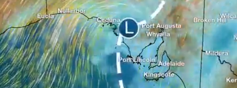
Image credit: BOM
Widespread damaging and locally destructive winds including potentially multiple small and fast-moving tornadoes battered parts of South Australia, causing significant tree and property damage across Adelaide, particularly the southern suburbs, the Australian Bureau of Meteorology reports.
South Australia has again experienced a wet and very windy few days due to the passage of multiple low pressure systems and cold fronts since Thursday, July 22, 2021.
"On Saturday we saw widespread damaging and locally destructive winds, including potentially multiple small and fast-moving tornadoes, causing significant tree and property damage across Adelaide particularly, the southern suburbs," said Tina Donaldson, BOM's Senior Meteorologist.
"At this stage, looking at radar evidence and damage patterns, they indicate there were multiple small and fast-moving tornadoes along a cold front that moved through around midday. The showers and thunderstorms associated with the front produced narrow paths of damaging to destructive winds."
A wet and very windy day for #SouthAustralia today. A fast-moving cold front with showers, thunderstorms and strong winds can be seen on satellite imagery west of Kangaroo Island moving eastwards over the state today. A #SevereWeatherWarning is current https://t.co/5wxFrWeCue pic.twitter.com/1BpqAIIvZQ
— Bureau of Meteorology, South Australia (@BOM_SA) July 23, 2021
"Large amounts of small hail settled on the ground could have been mistaken for snow, particularly in the Adelaide Hills region, however, observations suggest small hail was more likely. Small hail was also reported across the Adelaide metropolitan area," Donaldson said.
"This system also saw showers and rainfall across the state. The highest rainfall totals in the 24 hours to 09:00 LT on Sunday, July 25 were 42 mm (1.6 inches) at Ashton, 40 mm (1.5 inches) at Lenswood, and 33 mm (1.2 inches) at Balhannah.
12 mm (0.47 inches) was observed at Adelaide West Terrace/Ngayirdapira.
Some of the most significant observations:
- Gusts of 90 – 100 km/h (56 – 62 mph) were recorded across parts of southern South Australia, including Adelaide and the Mount Lofty Ranges.
- The highest gust recorded in the Adelaide area was 95 km/h (59 mph) at Adelaide Airport on Saturday evening.
- The highest gust in SA since Thursday was 107 km/h (66 mph) at Cape Borda and 135 km/h (84 mph) at Neptune Island.

Teo Blašković founded The Watchers in 2011 and edited it until 2026, covering seismic and volcanic activity, extreme weather, space weather and near-Earth objects. Articles on this page are his archive.
Earlier reporting
Nothing on Watchers was published in the last 24 hours. These are older articles.
- CPC posts a slight risk of heavy rain from the Gulf Coast to the Northeast urban corridor November 25-29, and a moderate risk of West Coast wind and Sierra snow on November 25
- The storms drenching California this week are fed by a river in the sky, a band of water vapor that can carry up to 15 times the flow of the Mississippi River, and this winter’s near-record El Niño could keep aiming more of them at the West Coast
- Atmospheric river brings moderate risk of heavy rain, mountain snow and high winds to northern California and southwest Oregon on November 24-25
- 190 mm of rain and 131 km/h gusts hit New Zealand's South Island, flooding West Coast highways
