
Heavy snowfall hits parts of Atlantic Canada, causing traffic chaos
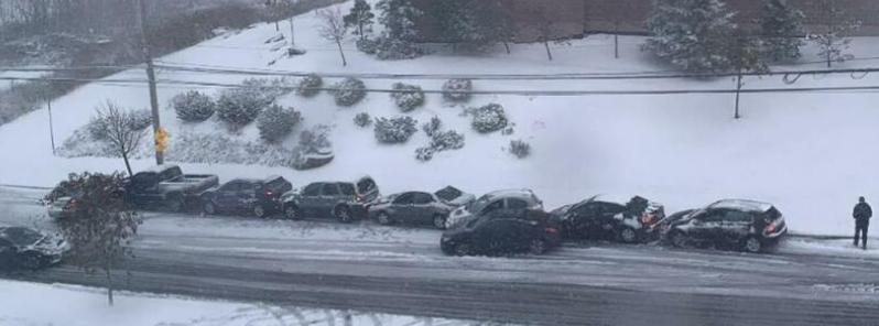
Image credit: @halifaxoise/Twitter
Heavy, significant snow accompanied by strong northwesterly winds resulted in dangerous commute conditions in parts of Atlantic Canada on Tuesday and Wednesday, November 3 and 4, 2020. Multiple road accidents were reported in Nova Scotia, while in Newfoundland, some schools were closed and drivers were urged to avoid travel.
In Nova Scotia, the first snowfall of the season, which fell on Tuesday, created "chaos and gridlock," according to local media.
Halifax police responded to more than 80 calls as multiple crashes were reported, including one on the Macdonald bridge, which shut down for a couple of hours, and a nine-car pile-up in Clayton Park.
At one point, both the Macdonald and MacKay bridges were closed due to car collisions. Up to 10 cm (3.9 inches) of snow resulted in slippery road conditions. No injuries were reported from the collisions.
Motorists took to social media to share their experiences on the road, saying it took them several hours to get home in a commute that usually takes only 20 to 30 minutes as traffic went standstill for hours.
From @thehubleyeffect pic.twitter.com/5lysgfu8gx
— halifaxnoise (@halifaxnoise) November 3, 2020
Drive with caution and to conditions, slow down and give space between yourself and the motorist or road user ahead of you. Clear your windows and vehicle. Be patient and avoid distractions. Stay safe out there this afternoon. pic.twitter.com/d55SYzCqPc
— Halifax_Police (@HfxRegPolice) November 3, 2020
From @laurrakirky https://t.co/dC9sdoynS3 pic.twitter.com/jJqyXcx9kB
— halifaxnoise (@halifaxnoise) November 3, 2020
In Newfoundland, the snow that fell through the overnight hours made for a dangerous Wednesday commute across parts of eastern and northeastern Newfoundland.
Heavy snow accompanied by strong northwesterly winds prompted some schools to close in the morning, while drivers were advised to avoid travel.
"The higher snowfall totals in Nova Scotia has a lot to do with the exact track of the low-pressure system. In this case, the center of the low was positioned just south enough to bring steady snowfall to the region and remain as snow," explained Weather Network meteorologist Jessie Uppal.
"Had the positioning of the track shifted a bit further north, we would have seen a lot more rain mixing in."
We've had some snow. #NLwx #stalbansnl pic.twitter.com/N0EC32Txh0
— Melissa Burke (@nlmsb) November 4, 2020
6am snow pics… #Gander #Nlwx pic.twitter.com/NYkTFVxkY0
— Sonya (@sonyatulk) November 4, 2020
Commenting rules and guidelines
We value the thoughts and opinions of our readers and welcome healthy discussions on our website. In order to maintain a respectful and positive community, we ask that all commenters follow these rules.