
Worst storm in over a century hits Spain, major floods and tornadoes reported
Featured image: Major flood in Valencia, Spain on September 12, 2019. Credit: Batalleta
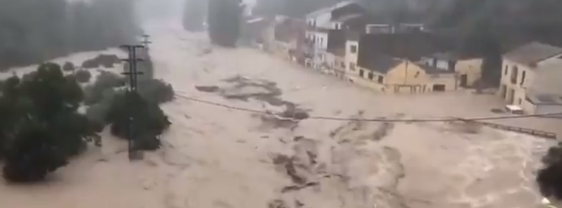
A slow-moving storm system pummelled a massive area of Spain, spawning floods, hails, thunderstorms, and tornadoes on September 12, 2019. Torrential rains put Costa Blanca around Benidorm and Alicante under red weather alert and killed two in Valencia region. The storm was described as the worst in more than a century.
Violent weather prompted Spain to brace for further widespread destruction as rains across the southern area were recorded the worst since 1917.
Footages of the river-like floodings went viral online, showing several vehicles being dragged by muddy waters. Fortunately, the cars had no passengers, officials said.
¡Tremendo! Esta mañana (12/09/2019), coches arrastrados por el agua en #Mogente / #Moixent (#Valencia). Superando ampliamente los 350 l/m² en lo que va de día en dicha zona. Esperemos que no hubiera nadie dentro de los vehículos. @severeweatherEU @StormchaserUKEU. Vídeo: @avamet. pic.twitter.com/Hrk2mPpJgN
— MeteOrihuela (@MeteOrihuela) September 12, 2019
Another view of MAJOR floods just off motorway A-7 in Orihuela, Alicante, east Spain today, September 12th! Report: Crevillent El Meu Poble pic.twitter.com/ivnES3XrQF
— severe-weather.EU (@severeweatherEU) September 12, 2019
Another video emerged showing the horrifying flash floods triggered by the overflowing of Clariano RIver in Ontinyent municipality, Vall d'Albaida, Valencia province on September 12.
The river burst its banks, causing 40 people to be rescued and 150 others to be promptly evacuated from their residences. Port de Sagunt has also been temporarily closed.
Aside from the Clariano river, the Canyoles river was also swollen, flooding the Bosquet ravine in Moixent.
AEMET, the country's weather agency, said that 71.8 mm (21.8 inches) of rain fell in Pego in Alicante province, 64.2 mm (2.5 inches) in Fontanars dels Alforins, 54.7 mm (2.1 inches) in Ibiza airport, and 33.4 mm (1.3 inches) in Murcia by 07:00 LT, September 12.
Through the morning of September 11, Ontinyent in the province of Valencia recorded a staggering 277.6 mm (10.93 inches) of rain, making September 12 its wettest day since records began in 1917.
Intense flooding in Ontinyent, Vall d'Albaida, Valencia, east Spain this morning, September 12th! Report: @Batalleta pic.twitter.com/rq7lwJaeDW
— severe-weather.EU (@severeweatherEU) September 12, 2019
MAJOR floods in Cantereria (Vall d'Albaida, València), eastern Spain this morning, September 12th – after already over 250 mm of rainfall, and expecting more! Reort: @avamet pic.twitter.com/qnKoscgVBC
— severe-weather.EU (@severeweatherEU) September 12, 2019
Two fatalities were reported in the region, who were suspected to be a married couple until officials confirmed that they were siblings aged 51 and 61. Further reports stated that the victims' car was swept away by floods.
Schools were canceled for over 338 000 students in Alicante and Valencia, while all classes in Murcia were suspended.
Aside from heavy rains, mudslides, and flash floods, authorities also issued risk of hails due to thunderstorms. According to reports, wind gusts may reach up to 72 km/h (45 mph) through September 12.
The severe weather conditions also summoned a tornado, as shown in a video posted by Severe Weather Europe. The twister is seen hitting Guardamar del Segura, Alicante on the morning of September 12.
It damaged the municipal sports center and ripped up trees, traffic signs and roofs. Winds of 104 km/h (64 mph) were recorded.
Affected areas can see another 50 – 100 mm (2 – 4 inches) of rain and up to 150 mm (6 inches) through Friday, AccuWeather meteorologists said.
Meanwhile, downpours in Madrid is expected to bring rains of 25 to 50 mm (1 to 2 inches).
A sudden drop in temperatures along the east coast due to the cold polar air is reported to be the reason behind the unusual weather conditions.
Since late August, other areas such as Ibiza, Majorca, and Madrid have been pounded by extreme weather. Ibiza remains under orange alert as further storms are forecasted in the upcoming days.
Does any one know if Moraira has been badly affected?
this is due to the GRAND SOLAR MINIMUM…remember crop shortages will follow in time…time to prepare
Second clean up in progress never seen so much rain in 12 years – muddy landslides. And we’re one of the lucky ones.
When you say 5 miles from Guardamar which direction? I have a place in La Marina Urbanisation? Any word on how they’re doing?
You should be fine. My in-laws are there and they’re ok. No fresh food being delivered though
apocalipse 2019 yeh
The last time in 1917 during the Centennial Minumum. Cycles of the Sun.
PSsshhd: most of those s-e-v-e-n b!lllllll!on sExperts don’t know it yet but the sun has even left its path around the Earth already.. Houston? say de nada.
Yea ya don’t say im smack in the middle of it.
Its hit and miss with the thunder storms but weve been hearing them for the last twelve hours.
Forcast models look very bad thro tonight and into Friday.
Were about 5 miles from Guardamar.
Thanks for reporting. Take care!