
Tropical Storm “Rosa” approaching Baja California, flooding, debris flows and landslides possible over parts of Mexico and western United States

Featured image: Tropical Storm "Rosa" at 08:15 UTC on October 1, 2018. Credit: NOAA GOES-East
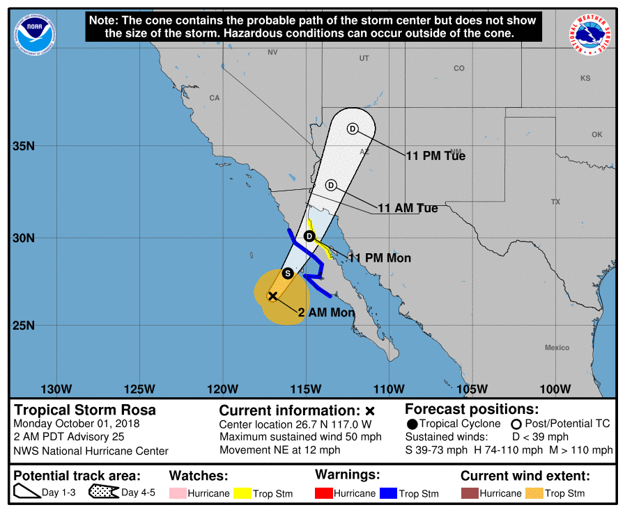
The center of Tropical Storm "Rosa" was located about 225 km (140 miles) WSW of Punta Eugenia, and 525 km (325 miles) SSW of San Felipe, Mexico at 09:00 UTC on October 1, 2018. Rosa is expected to produce heavy rain across Baja California and northwestern Sonora, Central and Southern Arizona and the rest of the Desert Southwest, Central Rockies and Great Basin. Life-threatening flash flooding is expected as well as dangerous debris flows and landslides in mountainous regions.
The storm had maximum sustained winds of 85 km/h (50 mph) at the time and was moving NW at 19 km/h (12 mph) with minimum central pressure of 994 hPa.
A Tropical Storm Warning is in effect for the west coast of the Baja California peninsula from Punta Abreojos to Cabo San Quintin. A Tropical Storm Watch is in effect for the east coast of Baja California from Bahia de Los Angeles to San Felipe.
On the forecast track, the center of Rosa will approach the central and northern Baja California later today and then move across the peninsula into the northern Gulf of California tonight (PDT).
Rosa is expected to produce 77 – 153 mm (3 to 6 inches) of rain across Baja California and northwestern Sonora, with isolated 254 mm (10 inches) possible.
Central and Southern Arizona can expect 51 – 102 mm (2 to 4 inches), and isolated totals of 153 mm (6 inches) possible in the mountains of Central Arizona.
The rest of the Desert Southwest, Central Rockies and Great Basin can expect 25 – 77 mm (1 to 2 inches) and isolated totals of 102 mm (4 inches).
These rainfall amounts may produce life-threatening flash flooding, dangerous debris flows and landslides in mountainous regions.
Swells generated by Rosa will affect portions of the coasts of southwestern Mexico, most of the west coast of the Baja California peninsula, and southern California through Tuesday. These swells are likely to cause life-threatening surf and rip current conditions.
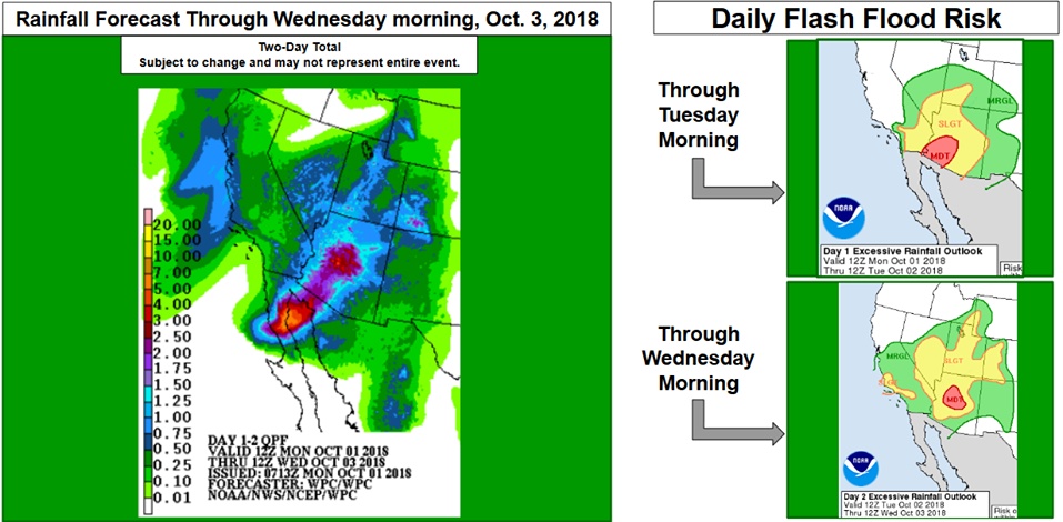
Rosa's remnants are expected to move across the Desert Southwest on Tuesday, October 2, producing heavy rain and bringing flash flood conditions to the Desert Southwest, Great Basin, and Central/Southern Rockies through Wednesday. There is a moderate risk of excessive rain in portions of Arizona today and tomorrow.
"Heavy rainfall has made a return to much of Arizona and southeastern California as Tropical Storm 'Rosa' tracks towards the northeast, and it is forecast to make landfall on the northern Baja California coast Monday evening," NWS said early October 1.
"There will be enough deep layer moisture to support widespread 25 – 77 mm (1 to 3 inches) rainfall amounts through Tuesday night, with some additional showers and thunderstorms likely falling thereafter. This moisture will continue spreading inland across eastern Nevada, Utah, and western portions of Colorado and New Mexico."
Flash flood watches are currently in effect for many of those areas, and the Weather Prediction Center currently has a moderate risk of excessive rainfall for parts of Arizona where the threat of flash flooding is greater.
I'm a dedicated researcher, journalist, and editor at The Watchers. With over 20 years of experience in the media industry, I specialize in hard science news, focusing on extreme weather, seismic and volcanic activity, space weather, and astronomy, including near-Earth objects and planetary defense strategies. You can reach me at teo /at/ watchers.news.
Commenting rules and guidelines
We value the thoughts and opinions of our readers and welcome healthy discussions on our website. In order to maintain a respectful and positive community, we ask that all commenters follow these rules.