
Tropical Storm “Max” hits Guerrero; Lidia to intensify into hurricane before Mexico landfall
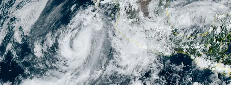
Featured image: Tropical storms Max and Lidia at 21:20 UTC on October 9, 2023. Credit: NOAA/GOES-East, RAMMB/CIRA, The Watchers
Tropical Storm “Max” formed at 03:00 UTC on October 9, 2023, and made landfall 15 hours later just west of Puerto Vicente Guerrero, Mexico, with winds of 105 km/h (65 mph). Originating south of Central America, the storm intensified rapidly, bringing with it a threat of heavy rainfall and potential mudslides. Max is closely followed by Lidia, currently an intensifying tropical storm, which is expected to make landfall over west-central Mexico as a hurricane.
Forming initially as a trough of low pressure south of Central America on October 3, the system saw associated showers and thunderstorms that increased in organization over the subsequent days. As the disturbance approached Acapulco by October 7, the National Hurricane Center (NHC) began issuing advisories, labeling it Potential Tropical Cyclone Sixteen-E. The system’s development into a well-defined circulation by the next day led to its reclassification as a tropical depression.
By 03:00 UTC on October 9, the once mild disturbance had intensified into a tropical storm and was named Max, becoming the 13th named storm of the 2023 Pacific hurricane season.
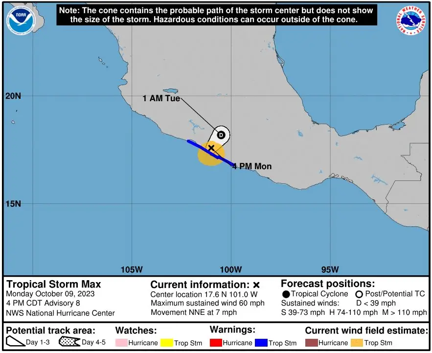
Tracking slowly to the north, its organization and strength saw a noticeable uptick. Making its landfall at 18:00 UTC, just west of Puerto Vicente Guerrero, the storm came with sustained winds of 65 mph (105 km/h) and recorded a minimum central pressure of 991 hPa (29.26 inHg).
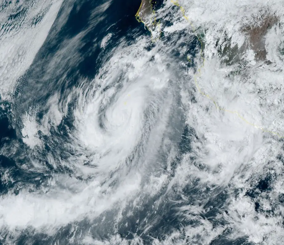
Further observations at 18:00 UTC on the same day located Tropical Storm Max’s center roughly 50 km (30 miles) southeast of Zihuatanejo, Mexico. The storm boasted maximum sustained winds of 95 km/h (60 mph) and gusts reaching up to 110 km/h (70 mph). The system was moving in a north-northeast direction at a speed of 7 km/h (5 mph), with a barometric pressure reading of 996 hPa.
A mere three hours later, at 21:00 UTC, Max’s center was located approximately 65 km (40 miles) from Zihuatanejo. Its sustained winds remained at 95 km/h (60 mph), but its direction shifted to the west, moving at a speed of 11 km/h (7 mph) and registering a pressure of 995 hPa.
Local authorities have issued a Tropical Storm Warning, spanning from Acapulco to Lazaro Cardenas. Tropical-storm-force winds are extending up to 95 km (60 miles) from its core.
Forecasts predict Max will result in rainfall ranging between 100 to 200 mm (4 to 8 inches), peaking at local amounts of up to 300 mm (12 inches) through October 10. Such heavy rainfall across Guerrero and Michoacan heightens concerns for flash and urban flooding, with a significant risk of mudslides in elevated coastal terrains.
Additionally, Max’s swells are predicted to impact Mexico’s southern coastlines over the next couple of days. These waves bring with them the potential for life-threatening surf conditions and dangerous rip currents. Residents and visitors are urged to stay updated through their local weather advisories.
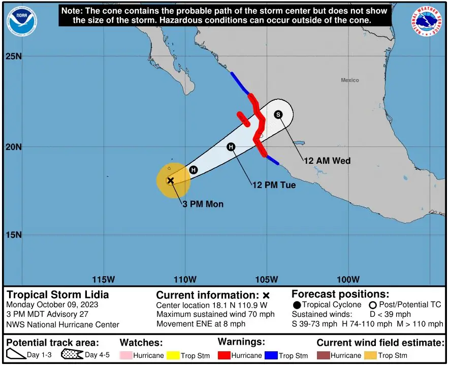
Max is closely followed by Tropical Storm “Lidia” — located about 605 km (340 miles) SW of Las Islas Marias, Mexico at 21:00 UTC today. The system had maximum sustained winds of 110 km/h (70 mph), it was moving ENE at 13 km/h (8 mph) and had minimum central pressure of 985 hPa.
A faster ENE motion is expected this evening and on Tuesday, October 10. The center of Lidia should approach Las Islas Marias on Tuesday, and move inland over west-central Mexico late Tuesday or Tuesday night.
A Hurricane Warning is in effect for Las Islas Marias, and Playa Perula to Escuinapa. A Tropical Storm Warning is in effect for Escuinapa to Bahia Tempehuaya, and Manzanillo to Playa Perula, Mexico.
Heavy rains from Lidia will likely produce flash and urban flooding, along with possible mudslides in areas of higher terrain across the state of Nayarit, southern portions of the state of Sinaloa, and coastal portions of the state of Jalisco in western Mexico.
A dangerous storm surge is expected near and to the south of where the center of Lidia moves over the Islas Marias and the coast of west-central Mexico.
Swells from Lidia will cause dangerous surf and rip current conditions along the west coast of Mexico and the Baja California peninsula during the next couple of days.
References:
1 Tropical Storm Max – Advisory Number 8 – NWS National Hurricane Center Miami FL EP162023 – 400 PM CDT Mon Oct 09 2023
2 Tropical Storm Lidia – Advisory Number 27 – NWS National Hurricane Center Miami FL EP152023 – 300 PM MDT Mon Oct 09 2023
The Watchers team and our contributors bring the latest on extreme weather, earthquakes, volcanic eruptions, space weather, and all things science. We're all about making sense of the natural world and keeping you informed on what’s happening. Got a tip or a question? Hit us up using the form at newstips!
Commenting rules and guidelines
We value the thoughts and opinions of our readers and welcome healthy discussions on our website. In order to maintain a respectful and positive community, we ask that all commenters follow these rules.