
Extremely dangerous Category 5 Hurricane “Otis” makes unexpected landfall near Acapulco, Mexico — at least 46 fatalities, 58 missing
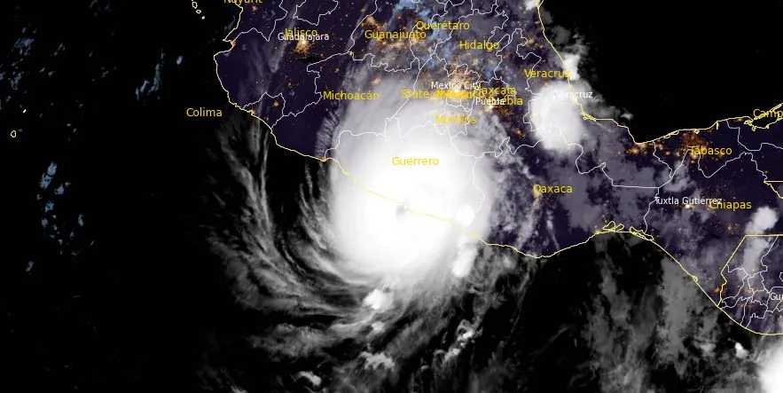
Featured image: Hurricane "Otis" at 06:30 UTC on October 25, 2023. Credit: NOAA/GOES-East, RAMMB/CIRA, The Watchers
Tropical Storm “Otis” explosively intensified into a Category 4 hurricane in just 12 hours and continued intensifying on its way toward Mexico where it made landfall at 06:25 UTC (00:25 LT) on October 25, 2023, as a Category 5 hurricane. This is now one of the fastest-intensifying hurricanes in the world’s history.
A nightmare scenario unfolded for southern Mexico this evening with rapidly intensifying Otis approaching the coastline, NHC forecaster Blake noted in a Forecast Discussion issued just 3 hours before landfall.
“This is an extremely serious situation for the Acapulco metropolitan area with the core of the destructive hurricane likely to come near or over that large city early on Wednesday. There are no hurricanes on record even close to this intensity for this part of Mexico.”
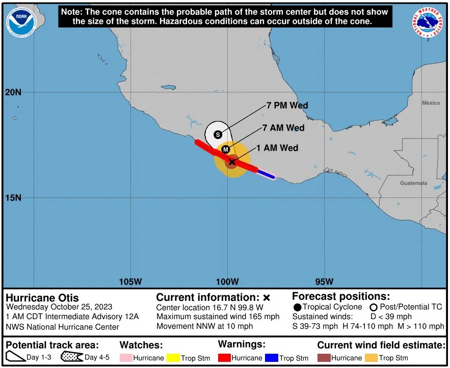
At the time of landfall, Otis was located about 10 km (6 miles) S of Acapulco (population 1 million+). It had maximum sustained winds of 270 km/h (165 mph) and a minimum central pressure of 923 hPa. It was moving NNW at 17 km/h (10 mph).
Since residents were expecting tropical storm landfall just a day before, Otis left them little time to find a safe shelter and protect life and property.
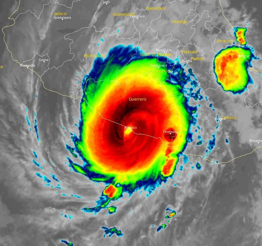
This is the first major hurricane (Category 3+) landfall within 80 km (50 miles) of Acapulco and the first Eastern Pacific hurricane ever recorded to make landfall as a Category 5 in Mexico.
Hurricanes of such strength are capable of producing catastrophic damage, especially in highly populated areas such as Acapulco.
A Hurricane Warning is in effect for Punta Maldonado westward to Zihuatanejo; a Hurricane Watch for Lagunas de Chacahua to Punta Maldonado; and a Tropical Storm Warning for Lagunas de Chacahua to Punta Maldonado.
Otis is forecast to continue moving inland over southern Mexico during the next day or so but rapid weakening is expected and the storm is expected to dissipate over southern Mexico on Wednesday night (local time).
Hurricane-force winds extend outward up to 45 km (30 miles) from the center and tropical-storm-force winds extend outward up to 110 km (70 miles).
Hurricane conditions are occurring within portions of the hurricane warning area and they will spread inland through this morning, with extremely destructive winds near the core. Winds affecting the upper floors of high-rise buildings will be significantly stronger than those near ground level. Tropical storm conditions will continue within portions of the warning areas through today.
A catastrophic storm surge is expected to produce life-threatening coastal flooding near and to the east of where the center makes landfall. Near the coast, the surge will be accompanied by large and destructive waves.
Otis is expected to produce rainfall totals of 200 to 400 mm (8 to 16 inches) with maximum amounts of 500 mm (20 inches) through Thursday across Guerrero and the western coastal sections of Oaxaca. This rainfall will produce flash and urban flooding, along with mudslides in areas of higher terrain.
Swells generated by Otis will affect portions of the southern coast of Mexico during the next day or so. These swells are likely to cause life-threatening surf and rip current conditions. Please consult products from your local weather office.
Updates
19:45 UTC, October 25
In the aftermath of Hurricane Otis, the southern state of Guerrero in Mexico experienced significant destruction. Social media posts revealed extensive damage to infrastructure, including wrecked rooms, torn ceilings and walls, and cars partially submerged in floodwaters. Mexican President Andrés Manuel López Obrador stated that no fatalities have been reported yet, but communication with the affected regions remains disrupted. The areas most severely impacted include Costa Grande, Acapulco, and Tecpán. The damage also extends to the local military airport, hindering the arrival of emergency teams. Authorities have reported widespread power outages across Guerrero. In addition, flights to and from Acapulco have been suspended, and educational institutions have cancelled classes due to the storm, one of the most potent to hit Mexico’s Pacific coast.
Here are the first daylight images coming out from Acapulco. This is Miguel Alemán Coastal Boulevard. Not looking good at all!! 😩#HurricaneOtis #HurracanOtis #Otis #Acapulco #México pic.twitter.com/lvrIFIs0fy
— Volcaholic 🌋 (@volcaholic1) October 25, 2023
OMG this is the Princess hotel in Acapulco. That's some serious damage!!! 😫#HurricaneOtis #HurracanOtis #Otis #Acapulco #México pic.twitter.com/MWauoK1bbG
— Volcaholic 🌋 (@volcaholic1) October 25, 2023
Otis was downgraded to a tropical storm at 18:00 UTC. The center of the storm was 205 km (130 miles) NNW of Acapulco. The system had maximum sustained winds of 95 km/h (60 mph) and a minimum central pressure of 995 hPa.
A Tropical Storm Warning is in effect for Punta Maldonado westward to Acapulco.
On the forecast track, the center of Otis will continue to move farther inland over southern Mexico later today and tonight. Continued rapid weakening is expected while Otis moves farther inland over the mountains of Mexico. Otis will likely dissipate over southern Mexico tonight.
SATELLITE SPOTLIGHT: @NOAA's #GOES18 🛰️ caught an incredible display of eye wall #lightning as Hurricane #Otis rapidly strengthened yesterday evening. According to @NHC_Atlantic, Otis was the strongest Eastern Pacific hurricane to make landfall in the satellite era. #Acapulco pic.twitter.com/auThP6ueUO
— NOAA Satellites – Public Affairs (@NOAASatellitePA) October 25, 2023
Before & after: This residential building in Acapulco, Mexico has been shredded by Category 5 Hurricane Otis’s extreme winds. pic.twitter.com/CLZzLoA6SZ
— Nahel Belgherze (@WxNB_) October 26, 2023
Mexico’s federal electricity commission said that Otis had cut power to 504 340 customers, although it was later restored to 202 932.
17:49 UTC, October 26
During a morning news briefing led by President Andres Manuel Lopez Obrador, Federal Security Secretary Rosa Icela Rodríguez announced that 27 deaths have been confirmed, along with four disappearances.
The level of devastation is so extensive that thousands of residents are currently stranded in their damaged homes without electricity. The impact of the hurricane has been so severe that not a single power line pole remains standing in the affected areas.
President Lopez Obrador said the small farmers bore the brunt of the storm, with their corn crops significantly damaged by the persistent wind and rain. He emphasized that the immediate restoration of power to the region is a critical priority.
07:57 UTC, October 29
The Mexican government updated the casualty figures from this week’s destructive Hurricane Otis in Acapulco, confirming that the death toll has now reached 39, with an additional 10 people reported missing. Looting persists in the region, exacerbating the already dire situation. Residents in the hardest-hit areas are facing severe shortages of food and water and have criticized the government for insufficient aid distribution.
In terms of infrastructure and utilities, local authorities report a substantial impact. Over 220 000 homes have suffered damage, representing a significant portion of the residential sector. The hotel industry, a key component of the local economy, has been severely hit, with 80% of the sector affected by the hurricane. Furthermore, electrical outages have been widespread, affecting more than 513 000 people in the region.
08:40 UTC, October 31
The number of fatalities rose to 48, of which 43 in the area of Acapulco City and 5 more in the area of the nearby Coyuca de Benitez Town. In addition, the media also reported 36 still missing persons across the affected area.
08:47 UTC, November 3
According to UN OCHA, 46 people died and 58 are still missing. In addition, more than 296 000 children in the five most affected municipalities are in need of humanitarian assistance and 177 804 students have been affected by school closure. Furthermore, 273 844 houses have been damaged, and critical infrastructure, such as hospitals, schools, ports and airports, suffered significant damage.
References:
1 Hurricane Otis Intermediate Advisory Number 12A – NWS National Hurricane Center Miami FL EP182023 – 100 AM CDT Wed Oct 25 2023
2 Hurricane Otis Tropical Cyclone Update – NWS National Hurricane Center Miami FL EP182023 – 125 AM CDT Wed Oct 25 2023
I'm a dedicated researcher, journalist, and editor at The Watchers. With over 20 years of experience in the media industry, I specialize in hard science news, focusing on extreme weather, seismic and volcanic activity, space weather, and astronomy, including near-Earth objects and planetary defense strategies. You can reach me at teo /at/ watchers.news.
Commenting rules and guidelines
We value the thoughts and opinions of our readers and welcome healthy discussions on our website. In order to maintain a respectful and positive community, we ask that all commenters follow these rules.