
Heavy snow and ice blanket portions of the interior Northeast and New England, US
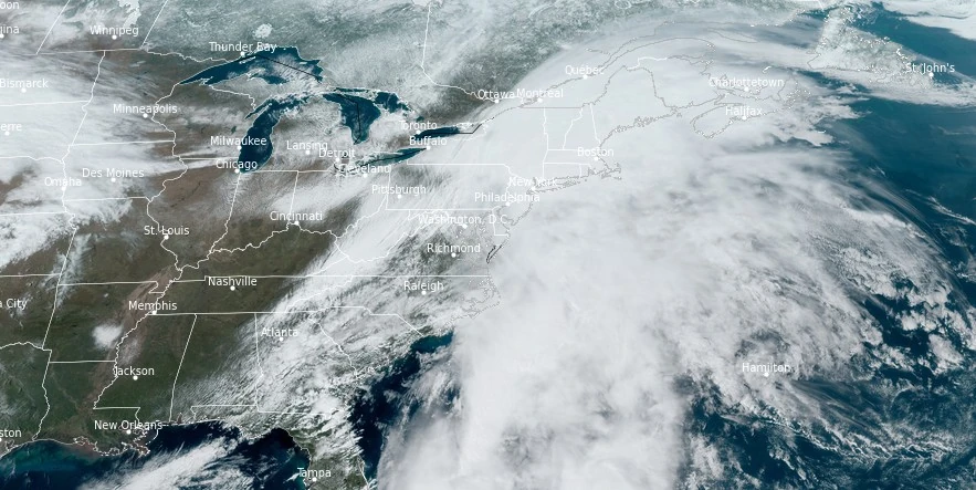
Image credit: NOAA/GOES-East, RAMMB/CIRA, The Watchers. Acquired at 19:00 UTC on March 23, 2023
Heavy rain, snow, and ice blanketed portions of the interior Northeast and New England on Friday and Saturday, March 22 and 23, 2024, causing widespread power outages, traffic chaos, and flight delays and cancellations.
The storm left more than 300 000 customers in Maine, New York and Hampshire without power. The worst affected was Maine with 200 000 customers without power (or about 800 000 people) and more than 100 000 in New York and New Hampshire. Early Monday morning, March 25, 103 000 customers were still without power in Maine, 23 000 in New Hampshire and 13 100 in New York.
On Saturday, March 23, rain-soaked highways and flooded underpasses led to numerous road-related issues, while the confluence of strong winds, heavy rain, fog, and slippery runways caused a substantial number of flight delays and cancellations at major airports, AccuWeather senior meteorologist, Alex Sosnowski, said.
“New York City experienced its third wettest March day on record last Saturday, receiving 93 mm (3.66 inches) of rain, with the majority falling within six hours,” stated AccuWeather Senior Meteorologist Reneé Duff. “The record for the wettest March day in New York City’s Central Park stands at 108 mm (4.25 inches), set back on March 25, 1876.”
“With Saturday’s downpour included, New York City has accumulated 209 mm (8.24 inches) of rain this March, ranking it sixth on the list of all-time wettest Marches,” AccuWeather New York City Meteorologist and On-Air Radio Personality Matt Benz said.
Additionally, the torrential rain, impacting a broad area along the Interstate 95 corridor and extending into the central Appalachians, resulted in 78.5 mm (3.09 inches) of rainfall in both Philadelphia and Providence, Rhode Island, and 57.9 mm (2.28 inches) in Boston.
Selected preliminary peak wind gusts, as reported by NWS Weather Prediction Center:
| State | Location | Peak wind gusts (km/h/mph) |
|---|---|---|
| Connecticut | New London Airport | 71 / 44 |
| Maryland | Mallops Flight | 76 / 47 |
| Maryland | Assateague Island | 64 / 40 |
| Massachusetts | Nantucket Memorial Airport | 97 / 60 |
| Massachusetts | New Bedford Regional Airport | 82 / 51 |
| Massachusetts | Otis Air National Guard | 71 / 44 |
| New Hampshire | Mount Washington | 101 / 63 |
| New York | Westchester County Airport | 77 / 48 |
| New York | Kennedy International Airport | 76 / 47 |
Preliminary storm total snowfall:
| State | Location | Snowfall (cm/inches) |
|---|---|---|
| Maine | Bryant Pond | 63.5 / 25 |
| Fort Fairfield | 61.0 / 24 | |
| Lovell 1 NNE | 57.15 / 22.5 | |
| Hartford | 45.72 / 18 | |
| Dover-Foxcroft | 38.1 / 15 | |
| Norway | 36.83 / 14.5 | |
| Sweden 4 NNW | 34.29 / 13.5 | |
| Oxford 2 NE | 33.02 / 13 | |
| Westfield 2 NNW | 31.75 / 12.5 | |
| Enfield | 29.21 / 11.5 | |
| Greenville 4 E | 29.21 / 11.5 | |
| Livermore Falls 4 S | 29.21 / 11.5 | |
| Eustis 1 NNW | 27.94 / 11 | |
| Porter 3 N | 27.94 / 11 | |
| Caribou | 19.81 / 7.8 | |
| NWS Gray | 14.48 / 5.7 | |
| New Hampshire | Lebanon 4 SSW | 66.04 / 26 |
| Claremont 2 NNW | 64.77 / 25.5 | |
| Jackson 1 SE | 54.61 / 21.5 | |
| Woodsville 4 S | 50.8 / 20 | |
| Bradford 2 NNE | 46.99 / 18.5 | |
| Ellsworth 1 E | 45.72 / 18 | |
| Hanover | 45.72 / 18 | |
| Lebanon 3 W | 45.72 / 18 | |
| Waterville Valley 2 WNW | 44.7 / 17.6 | |
| Piermont 5 NE | 43.18 / 17 | |
| Campton 1 SSE | 41.4 / 16.3 | |
| Lincoln 2 NE | 41.4 / 16.3 | |
| Albany 3 SE | 40.64 / 16 | |
| New York | Paulet | 67.31 / 26.5 |
| Corinth | 52.07 / 20.5 | |
| Ganesvoort | 51.31 / 20.2 | |
| Lake Desolation | 48.77 / 19.2 | |
| Cossayuna | 48.26 / 19 | |
| Queensbury | 46.99 / 18.5 | |
| Glen Falls | 46.74 / 18.4 | |
| Ballston Spa | 45.72 / 18 | |
| Wilton | 45.72 / 18 | |
| Sarasota Springs | 44.96 / 17.7 | |
| Broadalbin | 43.18 / 17 | |
| Forest Park Mobile 2 N | 43.18 / 17 | |
| Fort Edward 1 NNW | 43.18 / 17 | |
| Granville | 43.18 / 17 | |
| Warrensburg | 43.18 / 17 | |
| Whitehall | 41.91 / 16.5 | |
| Loudonville | 15.24 / 6 | |
| Vermont | West Windsor | 83.82 / 33 |
| Landgrove | 81.28 / 32 | |
| Ludlow 3 S | 69.34 / 27.3 | |
| Shrewsbury | 66.04 / 26 | |
| Peru | 60.96 / 24 | |
| West Norwich 1 SE | 58.93 / 23.2 | |
| Windsor | 58.42 / 23 | |
| Quechee | 55.88 / 22 | |
| South Ryegate | 55.88 / 22 | |
| Taftsville | 55.88 / 22 | |
| West Rutland 1 SW | 55.88 / 22 | |
| White River Junction | 54.1 / 21.3 | |
| Woodstock | 53.34 / 21 | |
| East Thetford | 50.8 / 20 |
Preliminary storm total freezing rain ice amounts:
| State | Location | Freezing rain (mm/inches) |
|---|---|---|
| Connecticut | Pittsfield | 7.11 / 0.28 |
| Norfolk | 2.54 / 0.10 | |
| Maine | Kennebunk | 12.7 / 0.50 |
| Old Orchard Beach | 10.16 / 0.40 | |
| Falmouth | 7.62 / 0.30 | |
| Yarmouth | 6.35 / 0.25 | |
| Wiscasset 4 SW | 6.10 / 0.24 | |
| East Surry | 2.54 / 0.10 | |
| Eastport | 2.54 / 0.10 | |
| North Berwick | 2.54 / 0.10 | |
| South Windham 3 E | 2.54 / 0.10 | |
| Falmouth 2 WSW | 2.03 / 0.08 | |
| Searsport 3 WNW | 1.27 / 0.05 | |
| Massachusetts | Pittsfield Municipal Airport | 7.11 / 0.28 |
| Alford | 6.35 / 0.25 | |
| Harriman and West Airport | 2.54 / 0.10 | |
| New Hampshire | Concord 2 ESE | 7.11 / 0.28 |
| Jaffrey 1 ESE | 5.08 / 0.20 | |
| Bennington 1 WSW | 2.54 / 0.10 | |
| Meredith 2 WSW | 2.54 / 0.10 | |
| Contoocook 1 NW | 1.78 / 0.07 | |
| Northwood 2 ENE | 1.27 / 0.05 | |
| New Jersey | High Point | 16 / 0.63 |
| New York | Latham | 19 / 0.75 |
| Albany 2 W | 16.76 / 0.66 | |
| Boght Corners | 12.7 / 0.50 | |
| North Greenbush 1 NNE | 12.7 / 0.50 | |
| Sycaway 1 N | 12.7 / 0.50 | |
| Niskayuna | 10.16 / 0.40 | |
| Floyd Bennett Memorial | 7.11 / 0.28 | |
| Westmere 1 NE | 3.30 / 0.13 | |
| Clifton Park Center 2 S | 2.54 / 0.10 | |
| Pine Bush 2 SSE | 2.54 / 0.10 | |
| Pennsylvania | Pocono Mountains Muni | 8.13 / 0.32 |
| Vermont | Bennington State Air | 6.35 / 0.25 |
At 10:00 EDT on March 24, the system was exiting the East Coast of the United States, with residual gusty winds forecasted throughout the Northeast. The system’s two central lows were identified in the Canadian Maritimes, recorded at pressures of 999 hPa and 993 hPa, following the passage of a cold front that introduced a cooler air mass into the region.
Flood watches were still in place for portions of the Northeast, alongside an avalanche warning for areas within the White Mountains in New Hampshire. Flood warnings have also been issued for scattered areas throughout the Northeast.
References:
1 Storm Summary Number 3 for Northeast Winter Storm – NWS Weather Prediction Center College Park MD – 1100 AM EDT Sun Mar 24 2024
2 Merging March storms wallop NYC, northeastern US on 1st weekend of spring – AccuWeather – March 24, 2024
I'm a dedicated researcher, journalist, and editor at The Watchers. With over 20 years of experience in the media industry, I specialize in hard science news, focusing on extreme weather, seismic and volcanic activity, space weather, and astronomy, including near-Earth objects and planetary defense strategies. You can reach me at teo /at/ watchers.news.
Commenting rules and guidelines
We value the thoughts and opinions of our readers and welcome healthy discussions on our website. In order to maintain a respectful and positive community, we ask that all commenters follow these rules.