
Florida declares state of emergency, Subtropical Storm “Alberto” dropping heavy rain
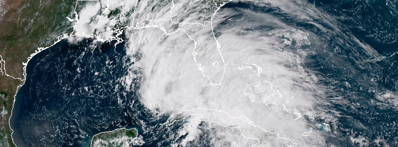
Featured image: Subtropical Storm "Alberto" at 21:00 UTC on May 26, 2018. Credit: NOAA/GOES-East
Florida has declared a state of emergency for all its 67 counties as the state continues to monitor and prepare for Subtropical Storm "Alberto." The cyclone has since formed a new eye and is now located over the southeastern Gulf of Mexico. Bands of heavy rainfall are already affecting western Cuba and southern Florida.
The declaration is ensuring the state and local government has ample time, resources and flexibility to get prepared for this storm.
"As we continue to monitor Alberto’s northward path toward Florida, it is critically important that all Florida counties have every available resource to keep families safe and prepare for the torrential rain and severe flooding this storm will bring," Governor Rick Scott said. "Yesterday, I directed the State Emergency Operations Center to activate to Level 2 and I will continue to be in constant communication with state and local emergency management officials as this storm approaches Florida."
"If any Florida family doesn’t have an emergency preparedness plan, now is the time to act. Remember, the track of these storms can change without notice. Do not think that only areas in the cone will be impacted – everyone in our state must be prepared. I encourage every Floridian to visit FloridaDisaster.org and get your plan before this storm hits so you can keep your family safe. We will continue to provide updates to Florida’s residents and visitors and do everything to prepare for and respond to this storm."
At 21:00 UTC on May 26, the center of Subtropical Storm "Alberto" was located 155 km (95 miles) N of the western tip of Cuba and 272 km (170 miles) of the Dry Tortugas, Florida. Its maximum sustained winds were 65 km/h (40 mph) and minimum central pressure 999 hPa.
A Storm Surge Watch is in effect for:
- Crystal River to the Mouth of the Pearl River
A Tropical Storm Warning is in effect for"
- Cuban province of Pinar del Rio
- Dry Tortugas
- Bonita Beach to Anclote River
- Aucilla River to the Mississippi/Alabama border
A Tropical Storm Watch is in effect for:
- Mississippi/Alabama border to the Mouth of the Pearl River
The cyclone is moving to the north near 20 km/h (13 mph). A slower northward or north-northeastward motion is expected tonight, followed by a north-northwest turn on Sunday, May 27 and this general motion should continue into Tuesday, May 29.
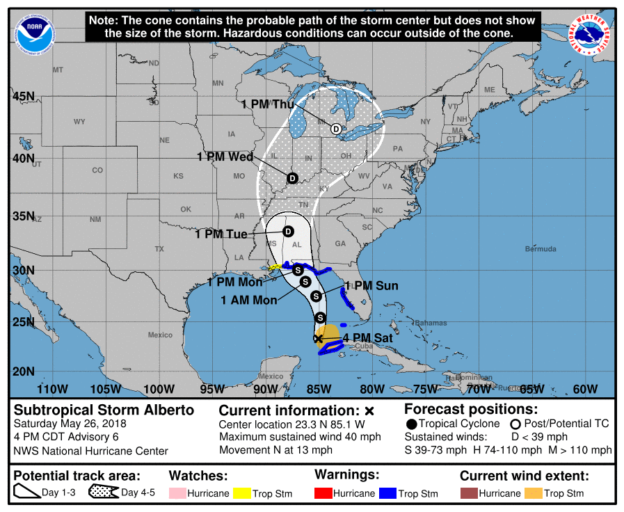
On the forecast track, the center of Alberto is forecast to move over the eastern Gulf of Mexico tonight through Sunday night, and approach the northern Gulf Coast in the warning area on Monday. Heavy rainfall and tropical storm conditions will likely reach the northern Gulf Coast well before the arrival of the center of Alberto.
Alberto is expected to produce total rain accumulations of 254 – 381 mm (10 to 15 inches) with isolated totals of 635 mm (25 inches) across western Cuba. These rains could produce life-threatening flash floods and mudslides.
Rainfall accumulations of 76 – 178 mm (3 to 7 inches) with maximum amounts of 254 mm (10 inches) are possible across the Florida Keys and southern and southwest Florida.
Heavy rains will begin to affect the central Gulf Coast region into the southeastern United States on Sunday and continue into the middle of next week as Alberto moves northward after landfall. Rainfall totals of 127 – 254 mm (5 to 10 inches) with maximum amounts of 381 mm (15 inches) are possible along the track of Alberto from eastern Louisiana, across much of Mississippi, Alabama, western Tennessee and the western Florida panhandle.
Rainfall totals of 76 – 127 mm (3 to 5 inches) with maximum totals of 203 mm (8 inches) are possible from the southern Appalachians into the coastal southeast United States.
The combination of storm surge and the tide will cause normally dry areas near the coast to be flooded by rising waters moving inland from the shoreline. The water could reach the following heights above ground somewhere in the indicated areas if the peak surge occurs at the time of high tide:
- Crystal River to the Mouth of the Pearl River: 0.6 – 1.2 m (2 to 4 feet)
The deepest water will occur along the immediate coast. Surge-related flooding depends on the relative timing of the surge and the tidal cycle, and can vary greatly over short distances.
Isolated tornadoes are possible this evening and tonight across parts of west-central Florida, including the Keys.
Swells generated by Alberto are expected to spread northward along the eastern and northern Gulf Coast through Monday. These swells are likely to cause life-threatening surf and rip current conditions.
I'm a dedicated researcher, journalist, and editor at The Watchers. With over 20 years of experience in the media industry, I specialize in hard science news, focusing on extreme weather, seismic and volcanic activity, space weather, and astronomy, including near-Earth objects and planetary defense strategies. You can reach me at teo /at/ watchers.news.
Commenting rules and guidelines
We value the thoughts and opinions of our readers and welcome healthy discussions on our website. In order to maintain a respectful and positive community, we ask that all commenters follow these rules.