
Tropical Cyclone 10S (Kelvin) to make landfall over Western Australia

Featured image: Soon to become Tropical Cyclone 10S / Kelvin February 16, 2018. Credit: NASA/NOAA Suomi NPP
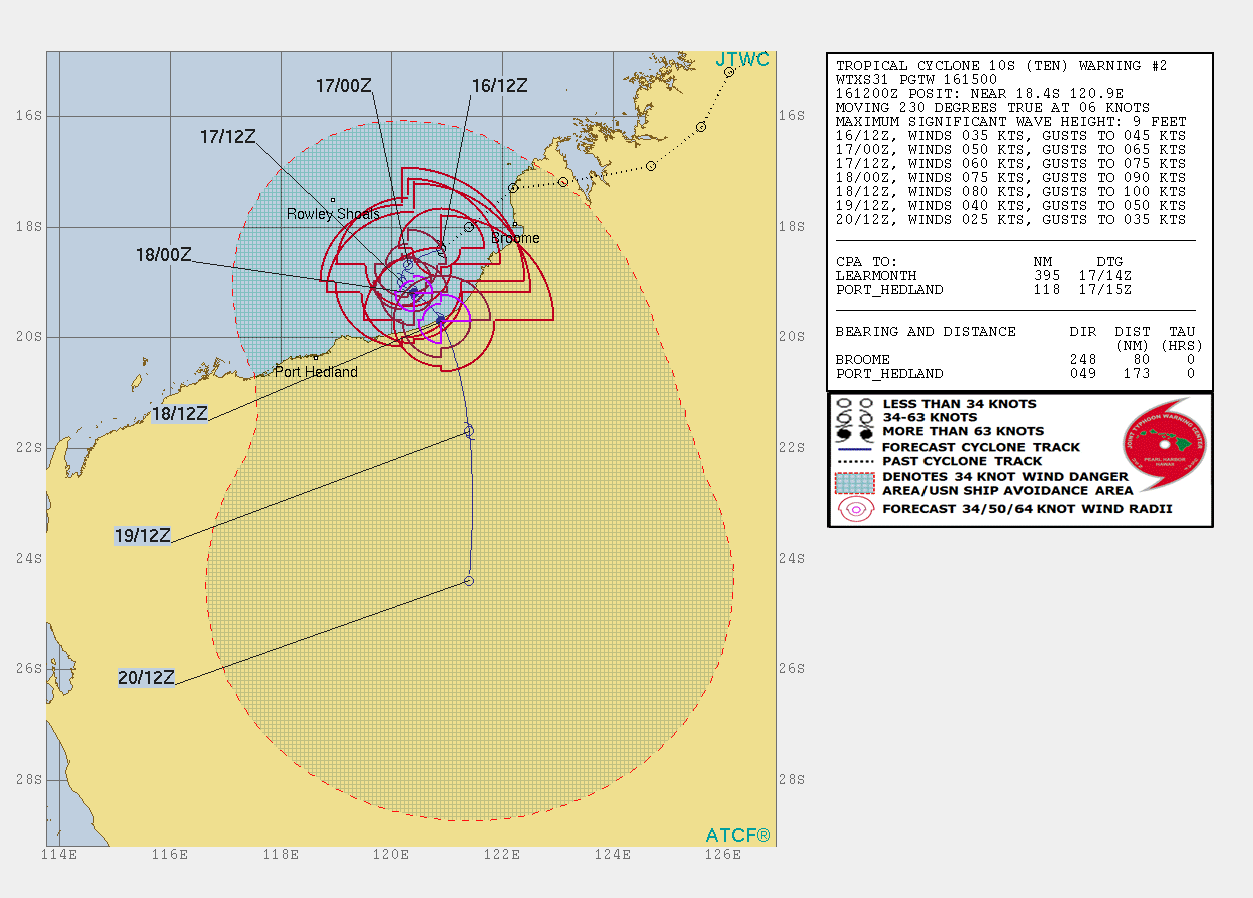
Tropical Cyclone 10S has formed just off the coast of northern Western Australia on February 16, 2018. The cyclone, still named Tropical Low 1 (17U) by BOM and soon to be internationally known as Kelvin, is expected to reach hurricane strength before making landfall over west Kimberley or east Pilbara coast on Sunday, February 18.
A Blue Alert has been issued for people between Cape Leveque and DeGrey, including Broome and Bidyadanga: prepare for cyclonic weather and organize an emergency kit including first aid kit, torch, portable radio, spare batteries, food and water.
Broome has already recorded 316 mm (12.44 inches) of rain between 09:00 AWST, February 16 and 02:52 AWST, February 17.
Conditions for further development of this cyclone are very favorable over open water. Sea surface temperatures are in the range of 27 to 29 °C (80.6 – 84.2 °F), wind shear is low, and there is evidence of good outflow aloft and upper divergence over the low, the Australian Bureaus of Meteorology said 19:08 UTC today.
The recent movement has the system closer to the coast than previously expected which may begin to inhibit its development as well as limiting its time over water. However if the low becomes slow-moving as models suggest and has 30 to 42 hours over water, it is possible the cyclone may reach an intensity of around 111 km/h (69 mph) [10-minute mean wind] before impacting the Western Australian coast, the agency said.
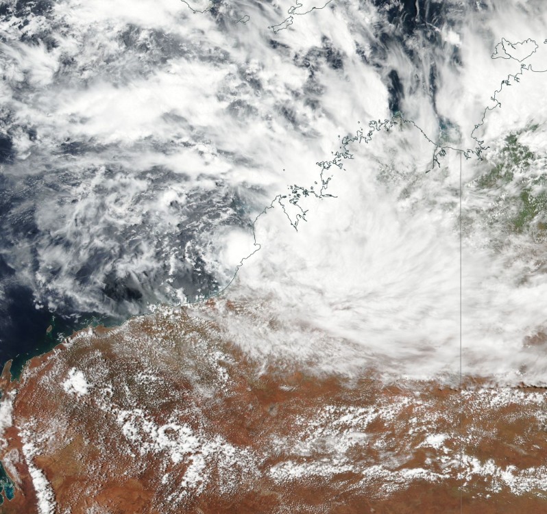
Soon to become Tropical Cyclone 10S / Kelvin February 16, 2018. Credit: NASA/NOAA Suomi NPP
At 18:52 UTC on February 16, the center of this system was located 130 km (81 miles) WSW of Broome and 60 km (37 miles) W of Bidyadanga. It had sustained winds near the center of 55 km/h (34 mph) with gusts to 85 km/h (53 mph).
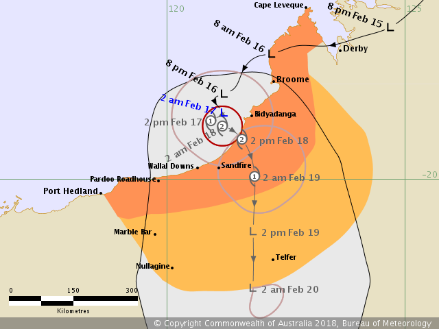
Forecast track by BOM at 18:52 UTC on February 16, 2018
Warning zone: Cape Leveque to Port Hedland, including Broome and Bidyadanga.
Watch zone: extending to the inland east Pilbara and the southwest Kimberley to include Marble Bar, Nullagine and Telfer.
GALES with gusts to 100 km/h (62 mph) may develop in coastal parts between Bidyadanga and Pardoo Roadhouse during Saturday. Gales may extend further west towards Port Hedland Saturday night if the system takes a more westerly track. Gales may extend from Bidyadanga to Cape Leveque including Broome Sunday morning.
DESTRUCTIVE winds with gusts to 150 km/h (93 mph) may develop along the coast between Bidyadanga and Pardoo Roadhouse from Saturday evening.
ABNORMALLY HIGH TIDES could cause minor flooding at the coast between Broome and Pardoo during Sunday.
Heavy rainfall is likely to continue over the northwest and west Kimberley Saturday morning, extending into the east Pilbara on the weekend.
A Blue Alert has been issued for people between Cape Leveque and DeGrey, including Broome and Bidyadanga: prepare for cyclonic weather and organize an emergency kit including first aid kit, torch, portable radio, spare batteries, food and water.
Broome has already recorded 316 mm (12.44 inches) of rain between 09:00 AWST, February 16 and 02:52 AWST, February 17.
This region was devastated by a tropical low at the end of January with record-breaking 5-day rainfall, making this January its wettest month in history with a total rainfall of 942.2 mm (37.09 inches).
BOM's meteorologist Steph Bond said the conditions produced by this storm had been similar to a category one tropical cyclone. However, this weather event did not meet the criteria to be labeled a tropical cyclone.
Over 439 mm (17.28 inches) of rain fell within 24 hours across the Broome region on January 30, just short of its daily record of 476.6 mm (18.76 inches) recorded in January 1997.
I'm a dedicated researcher, journalist, and editor at The Watchers. With over 20 years of experience in the media industry, I specialize in hard science news, focusing on extreme weather, seismic and volcanic activity, space weather, and astronomy, including near-Earth objects and planetary defense strategies. You can reach me at teo /at/ watchers.news.
Commenting rules and guidelines
We value the thoughts and opinions of our readers and welcome healthy discussions on our website. In order to maintain a respectful and positive community, we ask that all commenters follow these rules.