
Record-breaking snowstorm hits Rockies, heaviest October snow in Montana since 1914
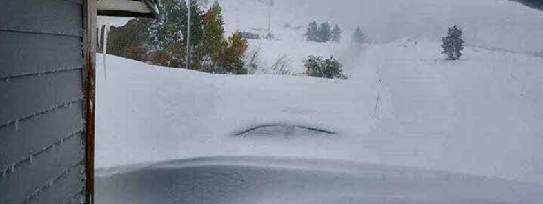
Featured image: Rocky Boy, Montana - October 3, 2017. Credit: Shawn & Steph White
Heavy snowstorm affecting the northern Rockies and parts of the central Rockies has turned record-breaking and resulted in widespread power outages and downed trees in parts of Montana and Colorado.
Havre, Montana experienced what was effectively a blizzard and recorded 37.6 cm (14.8 inches) of snow as of late Monday night, NWS Great Falls said. "However, with the power out, we'll need some time to verify the record." All of Havre was without power, Hill County sheriff said, with numerous trees and power lines down.
If the record is verified, this will be not only a daily record but a monthly, NWS said. "The current October record high snow is 21.8 cm (8.6 inches) set on October 4, 1914."
Public Information Statement issued by NWS Great Falls at 10:51 MDT, Tuesday, October 3, 2017, says storm total snowfall for Havre from Monday through Tuesday morning is 39.4 cm (15.5 inches).
"Unlike the snow the Rockies experienced in September, this storm is having a greater impact since valley locations are also being affected, in addition to typical mountain areas," Weather Channel's Chris Dolce explained.
The heaviest estimated snow amount from this storm is 76.2 cm (30 inches) in Rocky Boy, Montana. Drifts in at least one location were estimated to be 2.4 m (8 feet) high.
Some of the best video so far of this winter storm in Havre, MT. #mtwx @NWSGreatFalls @mikerawlins @STWXMT @wutv @TWCBreaking pic.twitter.com/12Zv9cnUuF
— Josh Miller (@millerjosh37) October 2, 2017
In addition to snow, gusty winds and temperatures near/below freezing are producing wind chills in the teens across N-cntrl #MTwx this aftn. pic.twitter.com/3sk2CcR7wU
— NWS Great Falls (@NWSGreatFalls) October 2, 2017
8:30am. Difficult conditions in Havre early this morning. Widespread power outage. Snow is ending. Photo courtesy Ann Kulczyk #mtwx pic.twitter.com/HHbZkXc2I8
— NWS Great Falls (@NWSGreatFalls) October 3, 2017
Still snowing in havre. Lots of damage everywhere #mtwx @mikerawlins @NWSGreatFalls #wutv pic.twitter.com/twNDEr0SDh
— Jasmine Miller (@Jazz1359) October 3, 2017
@mikeseidel This was taken in Rocky Boy, Montana! 30' of snow with 8' drifts in some places!! #mtwx #weatherchannel pic.twitter.com/L212uTKaS6
— Shawn & Steph White (@ShawnStephWhite) October 3, 2017
TFX issues Public Information Statement (PNS) https://t.co/UTcEejsKYL
— NWS Great Falls (@NWSGreatFalls) October 3, 2017
In Colorado, power outages began at around 20:00 local time on Sunday night and affected nearly 45 000 homes in Summit, Park and Lake counties, an Xcel Energy spokeswoman said. Roughly half of those lasted less than five minutes, but as of 23:00 there were still more than 10 000 homes without power.
Snow from the recent storm is atop the Flatirons this morning! Higher elevations saw up to 18". #cowx pic.twitter.com/V22UpTeWST
— NWS Boulder (@NWSBoulder) October 3, 2017
Snowfall intensity will increase again over the N/Cent Mtns later this morning & aftn. Heaviest snowfall above 9000ft & west slopes. #COwx pic.twitter.com/do8ERhivpq
— NWS Boulder (@NWSBoulder) October 2, 2017
Interstate 70 was closed in both directions at the Eisenhower Tunnel at around 18:30 local time Sunday night due to multiple crashes and again between Vail and Copper Mountain for a time Monday morning due to accidents and vehicles sliding off the icy road.
I'm a dedicated researcher, journalist, and editor at The Watchers. With over 20 years of experience in the media industry, I specialize in hard science news, focusing on extreme weather, seismic and volcanic activity, space weather, and astronomy, including near-Earth objects and planetary defense strategies. You can reach me at teo /at/ watchers.news.
Commenting rules and guidelines
We value the thoughts and opinions of our readers and welcome healthy discussions on our website. In order to maintain a respectful and positive community, we ask that all commenters follow these rules.