
Hurricane “Maria” expected to strike Leeward Islands early next week
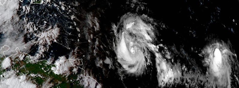
Featured image: Tropical storms Maria and Lee at 21:15 UTC on September 16, 2017. Credit: NOAA/GOES-16 (preliminary and non-operational).
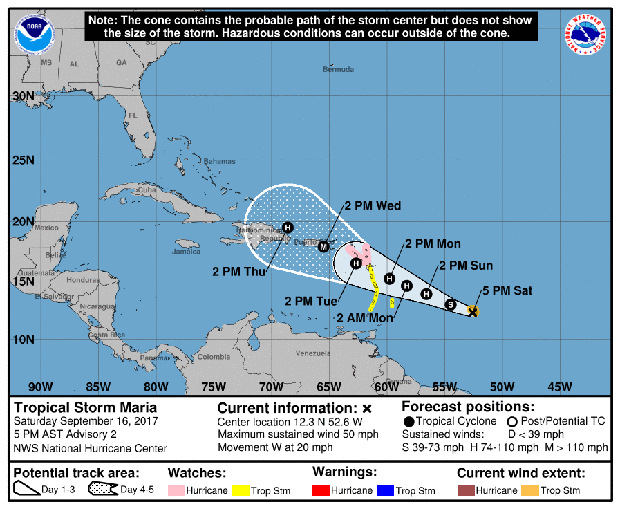
Tropical Storm "Maria" formed in the Atlantic Ocean at 21:00 UTC on September 16, 2017 as the 13th named storm of the 2017 Atlantic hurricane season. Maria is expected to be a Category 1 or 2 hurricane when it approaches the Leeward Islands early next week.
At 21:00 UTC on September 16, the center of Tropical Storm "Maria" was located about 1 000 km (620 miles) ESE of the Lesser Antilles. The system is moving west at 31 km/h (20 mph) with maximum sustained winds of 85 km/h (50 mph). Its estimated minimum central pressure is 1 002 hPa.
A slower WNW motion is expected during the next couple of days and Maria is expected to approach the Leeward Islands on Monday, September 18 as a hurricane.
The government of Antigua has issued a Hurricane Watch for Antigua, Barbuda, St. Kitts, Nevis, and Montserrat. A Hurricane Watch means that hurricane conditions are possible within the watch area. A watch is typically issued 48 hours before the anticipated first occurrence of tropical-storm-force winds, conditions that make outside preparations difficult or dangerous.
A Tropical Storm Watch is in effect for St. Lucia, Martinique and Guadeloupe, Dominica, Barbados, St. Vincent, and the Grenadines. A Tropical Storm Watch means that tropical storm conditions are possible within the watch area, generally within 48 hours.
Hurricane conditions are possible within the hurricane watch area by Monday night or Tuesday, with tropical storm conditions possible on Monday. Tropical storm conditions are possible in the tropical storm watch area on Monday.
A dangerous storm surge accompanied by large and destructive waves will raise water levels by as much as 0.9 – 1.5 m (3 to 5 feet) above normal tide levels within the hurricane watch area.
Maria is expected to produce total rain accumulations of 152.4 – 304.8 mm (6 to 12 inches) with isolated maximum amounts of 508 mm (20 inches) across portions of the central and southern Leeward Islands through Tuesday night.
Rainfall amounts of 50.8 to 101.6 mm (2 to 4) inches with isolated maximum amounts of 203.2 mm (8 inches) will be possible for portions of the northern Leeward Islands through Tuesday night. These rains could cause life-threatening flash floods and mudslides.
Swells generated by Maria are expected to begin affecting the Lesser Antilles by Sunday night. These swells are likely to cause life-threatening surf and rip current conditions.
This storm is followed by another newly named tropical cyclone – Tropical Storm "Lee." However, this cyclone is expected to weaken into a tropical depression by Tuesday, September 19.
I'm a dedicated researcher, journalist, and editor at The Watchers. With over 20 years of experience in the media industry, I specialize in hard science news, focusing on extreme weather, seismic and volcanic activity, space weather, and astronomy, including near-Earth objects and planetary defense strategies. You can reach me at teo /at/ watchers.news.
Commenting rules and guidelines
We value the thoughts and opinions of our readers and welcome healthy discussions on our website. In order to maintain a respectful and positive community, we ask that all commenters follow these rules.