
Tropical Storm “Malou” hits Okinawa, heading toward Tokyo, Japan

Featured image: Tropical Storm "Malou" over Okinawa, Japan at 06:30 UTC on September 6, 2016. Credit: UW-CIMSS
Tropical Storm "Malou" has formed early Tuesday, September 6, 2016, following the gradual development of a low pressure area off of the monsoonal trough northeast of Luzon, Philippines. The system is already bringing flooding rain to Okinawa.
"This storm is still not very good looking compared to what a standard typhoon looks like for this region, but it contains a lot of moisture which makes it dangerous," Meteorologist Robert Speta of the NHK and WestPacWx said.
At 06:00 UTC on September 6, the center of Tropical Storm "Malou" was located about 131 km (81 miles) ENE of Kunigami, Okinawa. Its maximum sustained winds were 74 km/h (46 mph) and gusts to 111 km/h (69 mph), according to the Japan Meteorological Agency.
The system is moving to the northeast at 26 km/h (16.1 mph). Malou's minimum estimated central pressure at the time was 1 000 hPa.
JMA expects Malou to continue strengthening and have maximum sustained winds of 101.8 km/h (63.3 mph) by 06:00 UTC on September 8. At the time, the center of Malou is expected to be located about 84 km (52.7 miles) south of downtown Tokyo, moving NE at 39 km/h (24 mph).
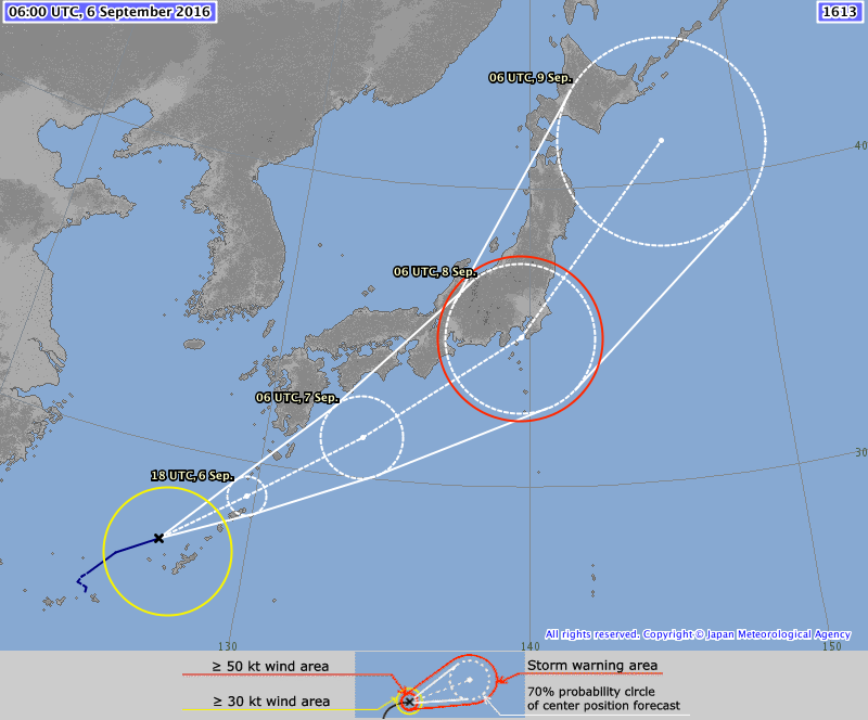
Tropical Storm "Malou" forecast track by JMA on September 6, 2016
According to Speta, flooding is possible in Okinawa and people commuting around the island through the coming day should be aware of the hazards with this storm including low-lying flooding and short time wind gust within the stronger cells embedded within in the storm. The worst of the storm is expected to roll over Okinawa Honto Tuesday evening through the overnight hours before gradually improving Wednesday.
"The long range track of Malou also shows the storm skirting the coast of Mainland Japan later this week. The intensity stays below typhoon threshold but with this being the 5th storm to hit the country in only a few short weeks the probability of flooding is heightened," Speta said.
See his analysis and forecast in the video below:
Video courtesy Robert Speta (NHK/WestPacWx)
The Watchers team and our contributors bring the latest on extreme weather, earthquakes, volcanic eruptions, space weather, and all things science. We're all about making sense of the natural world and keeping you informed on what’s happening. Got a tip or a question? Hit us up using the form at newstips!
Commenting rules and guidelines
We value the thoughts and opinions of our readers and welcome healthy discussions on our website. In order to maintain a respectful and positive community, we ask that all commenters follow these rules.