
Darby hits Hawaii, Frank swirls near Mexico, Georgette becomes a hurricane
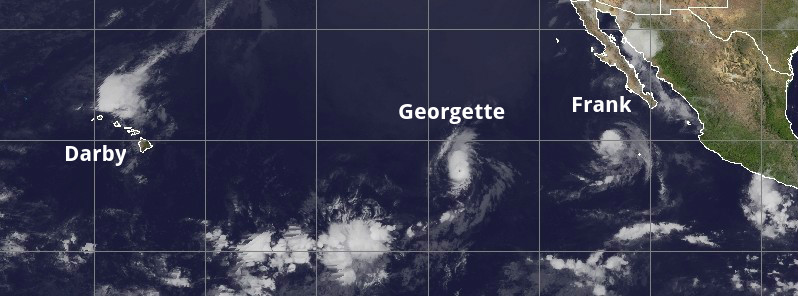
Featured image: GOES-West infrared image Frank, Georgette, and Darby on July 25, 2016. Credit: UW-CIMSS
As of 12:00 UTC on July 25, 2016, there are 3 active tropical systems in the central and eastern Pacific – Tropical Storm "Darby", Tropical Storm "Frank" and Hurricane "Georgette". While Darby hit Hawaii over the weekend and is still affecting the islands with locally very heavy rain, both Frank and Georgette are moving away from the coast of Mexico, and neither are expected to pose any risks to Hawaii.
Thanks to strong winds, which act as a protective shield, Hawaii's has the ability to dodge storms. This made Darby only the fifth tropical cyclone to hit Hawaii since 1949.
Tropical Storm "Darby" formed off the coast of western Mexico on July 12, 2016, and developed into the third hurricane of the 2016 eastern Pacific hurricane season by July 13. The system has weakened to a tropical storm on July 20 as it approached the central Pacific Ocean.
Darby made landfall near Pahala on Hawaii's Big Island Hawaii around 23:00 UTC on July 23 with maximum winds of 65 km/h (40 mph), bringing very heavy rain. Landfall location is in the vicinity of where Iselle made landfall in 2014.
Tropical Storm "Darby" as seen by Suomi NPP from July 21 – 24, 2016. Credit: NASA/NOAA/DoD Suomi NPP / VIIRS
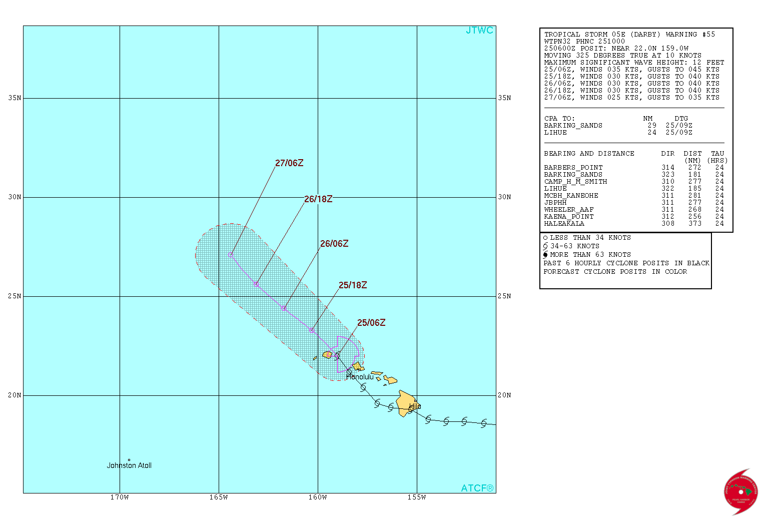
Tropical Storm "Darby" forecast track by JTWC on July 25, 2016
Preliminary rainfall totals indicate that more than 127 mm (5 inches) fell along the eastern slope of Mauna Loa in the 24 hours ending early Sunday morning, July 24 (local time).
State's emergency management reported on Saturday that flooding has closed a road in the Hamakua district of the Big Island. Portions of Interstate H-1 were also closed due to flooding on Sunday night, according to the National Weather Service office in Honolulu.
Although all that rain at once raised the risk of flash flooding and landslides, the rain was received as a blessing, as the state only received 60% of its average annual rainfall so far this year.
At 12:00 UTC on July 25, the center of Tropical Storm "Darby" was located about 105 km (65 miles) WNW of Lihue and 265 km (165 miles) WNW of Honolulu, Hawaii. The system is moving to the WNW near 19 km/h (12 mph) and this general motion is expected to continue over the next couple of days.
Maximum sustained winds were near 65 km/h (40 mph) with higher gusts. Darby is expected to weaken to a tropical depression in a couple of hours, and become post-tropical remnant low by Tuesday, July 26. Tropical-storm-force winds extend outward up to 110 km (90 miles) from the center, mainly to the northeast of the center. The estimated minimum central pressure is 1 010 hPa.
Additional rainfall of 50 – 100 mm (2 to 4 inches), with locally higher amounts, can be expected over portions of the Hawaiian Islands through today. These torrential rains could produce life-threatening flash floods and landslides, CPHC said.
Tropical Storm "Darby" – water vapor animation -July 25, 2016. Credit: NOAA
On Friday, July 22, Georgette officially became the seventh named storm to form in July, tying the record for most July named storm formations set in 1985, the U.S. NWS confirmed. Georgette is well off the coast and is not threatening any land.
NASA/JAXA's GPM found extremely heavy rain (red) falling at a rate of over 224 mm (8.8 inches) per hour and cloud top heights over 14 km (8.7 miles) high in storms south of Georgette's center.
Credit: NASA/JAXA/SSAI, Hal Pierce
Georgette became a hurricane late UTC on July 23, the fourth this month in northeast Pacific, tying July record for hurricanes last set in 1992.
On July 24, it became a major hurricane, the third in northeast Pacific this month, tying the July record set in 1978 and 1992.
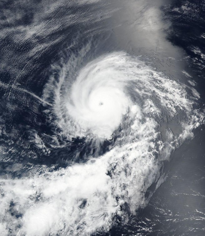
Hurricane "Georgette" on July 24, 2016. Credit: NASA/NOAA/DoD Suomi NPP / VIIRS
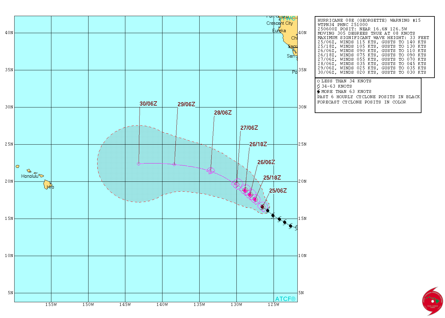
Hurricane "Georgette" forecast track by JTWC on July 25, 2016
At 09:00 UTC on July 25, the center of Hurricane "Georgette" was located about 1 885 km (1 170 miles) WSW of the southern tip of Baja California, Mexico. The system is moving toward the northwest near 17 km/h (10 mph), and this motion with a decrease in forward speed is expected during the next couple of days, NHC said.
Maximum sustained winds are near 215 km/h (130 mph) with higher gusts, making Georgette a category 4 hurricane on the Saffir-Simpson Hurricane Wind Scale. Weakening is expected during the next 48 hours, and Georgette is likely to fall below hurricane strength on
Wednesday, July 27.
Georgette is a small tropical cyclone. Hurricane-force winds extend outward up to 35 km (25 miles) from the center and tropical-storm-force winds extend outward up to 75 km (45 miles). The estimated minimum central pressure is 952 hPa.
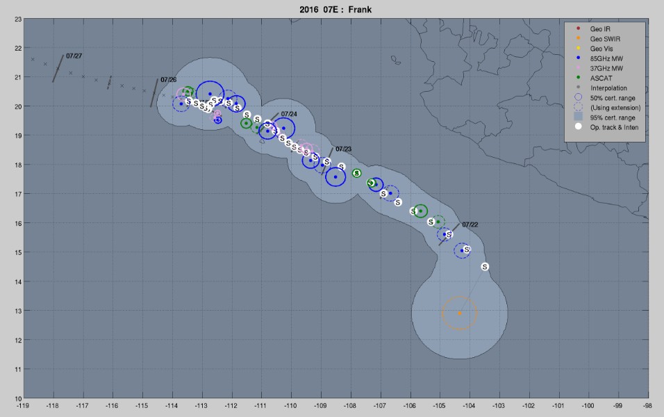
Tropical Storm "Frank" track by UW-CIMSS – July 25, 2016
Tropical Storm "Frank" formed late July 21, 2016, about 455 km (285 miles) south of Manzanillo, Mexico, as the sixth named storm of the 2016 eastern Pacific hurricane season.
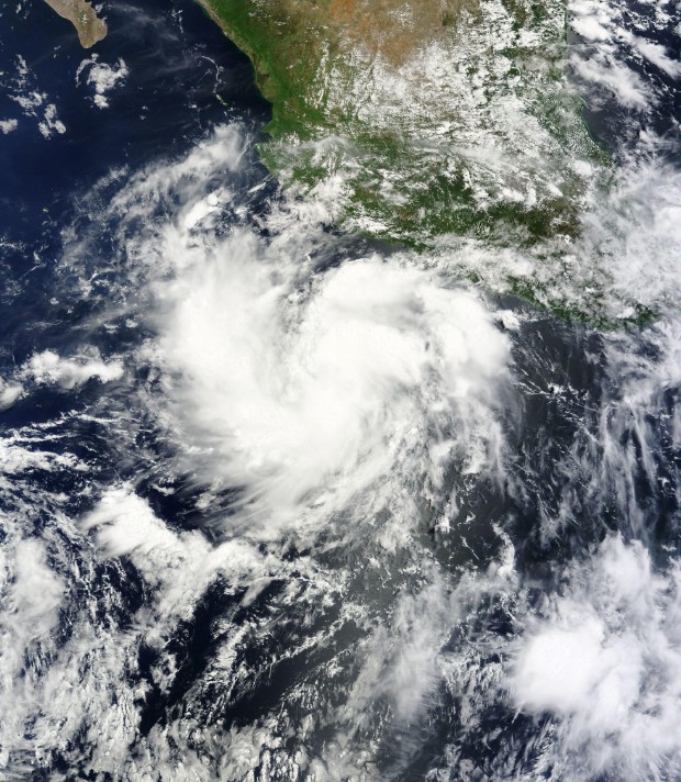
Soon to become Tropical Storm "Frank" on July 21, 2016. Credit: NASA Terra/MODIS
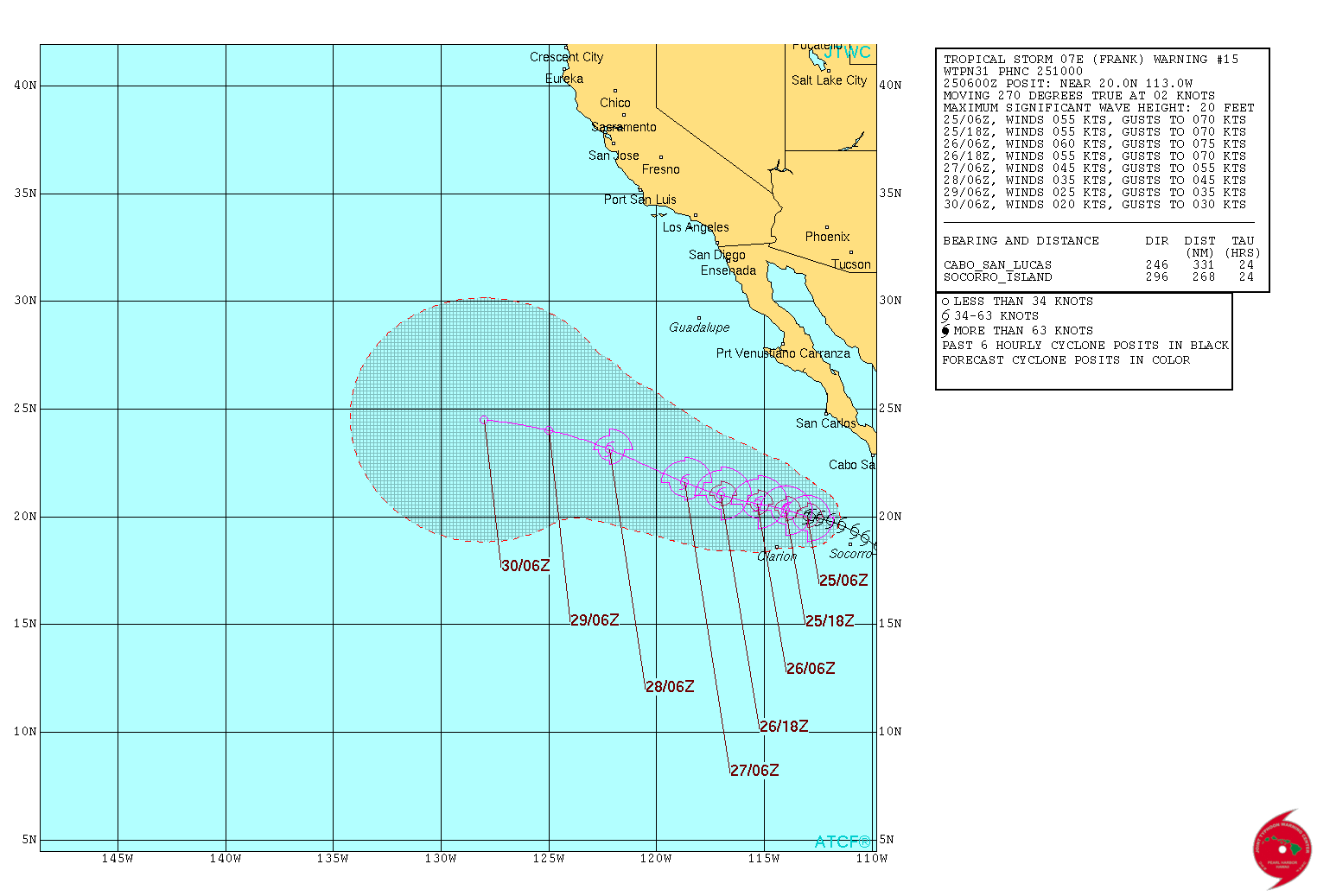
Tropical Storm "Frank" forecast track by JTWC on July 25, 2016
At 09:00 UTC on July 25, the center of Tropical Storm "Frank" was located about 460 km (285 miles) SW of the southern tip of Baja California.
The system had maximum winds of 100 km/h (65 mph) and was moving west at 6 km/h (3 mph). The estimated minimum central pressure was 994 hPa. A WNW motion at a faster speed is expected over the next 48 hours. Some strengthening is possible during the next day or so.
Tropical-storm-force winds extend outward up to 130 km (80 miles) from the center.
Swells associated with Frank are affecting the coasts of the southern Baja California peninsula and the state of Sinaloa. These swells could cause life-threatening surf and rip currents.
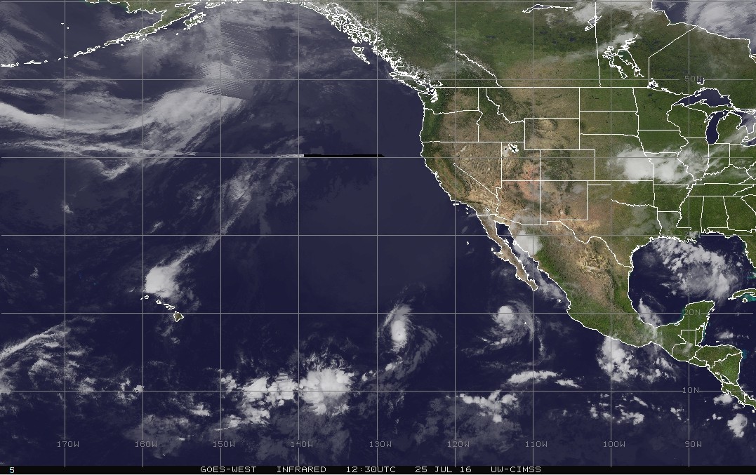
GOES-West infrared image Frank, Georgette and Darby on July 25, 2016. Credit: UW-CIMSS
This summer, the NE Pacific is already showing a positive SST anomaly pattern and model predictions indicate that by September, it could intensify further with values ranging anywhere from 37 °C (98.6 °F) to 39 °C (102.2 °F) off the coast of Alaska and Canada, The Weather Network said.
Although this is a different ocean-atmosphere interaction signal to keep an eye on, the warmer waters in the north Pacific will probably have an effect on the nature of the Pacific Northwest storms moving into the region later this Fall. However, the warmer SST anomalies to the south, off the west coast of Mexico and Central America, could have a weakening effect on hurricane development and intensification in the Atlantic Ocean basin in the coming months.
According to CSU Meteorologist Philip Klotzbach, the NE Pacific has generated more Accumulated Cyclone Energy (ACE) this month than the entire 2015 Atlantic hurricane season.
The Watchers team and our contributors bring the latest on extreme weather, earthquakes, volcanic eruptions, space weather, and all things science. We're all about making sense of the natural world and keeping you informed on what’s happening. Got a tip or a question? Hit us up using the form at newstips!
Commenting rules and guidelines
We value the thoughts and opinions of our readers and welcome healthy discussions on our website. In order to maintain a respectful and positive community, we ask that all commenters follow these rules.