
Super Typhoon “Nepartak” to hit Taiwan and East China

Featured image: Super Typhoon "Nepartak" at 07:10 UTC on July 6, 2016. Credit: JMA/HIMAWARI-8
Nepartak has rapidly strengthened into a major typhoon on July 5, 2016, and the current JTWC forecast track takes it right over the northern Taiwan on July 7 and over the coast of East China as it makes a second landfall on July 8. A poleward turn is expected after China landfall, right toward Shanghai and the Korean Peninsula. Very heavy rain and powerful winds are expected across the region.
Nepartak became a tropical storm on Sunday, July 3, 2016. It is the first named storm of the 2016 Pacific typhoon season, and the first internationally named storm in this region since December 17, 2016. Within the first 48 hours, Nepartak rapidly strengthened into a super typhoon. Within 24 hours, its winds increased from 110 km/h (70 mph) to 240 km/h (150 mph).
At 03:00 UTC on July 6, Super Typhoon "Nepartak" was located approximately 1 135 km (705 miles) southeast of Taipei, Taiwan. Over the past six hours, it tracked WNW at 35 km/h (20 mph). Animated multispectral satellite imagery shows the system has become more compact, symmetrical, and displaying annular characteristics as the eye expanded to 29 km (18 miles).
At the time, Nepartak's maximum sustained winds were 259 km/h (161 mph), with gusts to 315 km/h (195 mph). Maximum significant wave height at 00:00 UTC today was 13.4 m (44 feet).
At 06:00 UTC, Nepartak had a central pressure of 900 hPa, according to JMA.
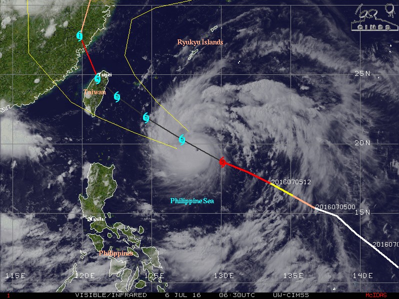
Super Typhoon "Nepartak" at 06:30 UTC on July 6, 2016. Credit: UW-CIMSS
Landfall over the northern Taiwan is expected sometime after 18:00 UTC on Thursday, July 7, with maximum sustained wind speed near 259 km/h (161 mph). This would make Nepartak a very dangerous, category 4 or 5 hurricane on the Saffir-Simpson Hurricane Wind Scale.
Nepartak is bringing very heavy rain (risk of flooding and landslides) and typhoon strength winds to Taiwan, and enhancement of the monsoon further down south, over the already soaked Philippines.
On the extended forecast track, Nepartak is expected to exit Taiwan after 00:00 UTC on July 8 and make a second landfall over the coast of East China sometime after 12:00 UTC on July 8. Its center is expected to pass just east of Shanghai after 00:00 UTC on July 10. Nepartak's exit into the Yellow Sea, toward the Korean Peninsula, is expected around 12:00 UTC on July 10.
Although this system will be weaker by the time it hits China it will still be a typhoon-strength storm bringing very heavy rain and strong winds. This is very bad news for the region already heavily soaked and flooded over the past weeks. More than 33 million people across 26 provinces have already been affected as China experiences its worst flooding since 1998. According to China's Meteorological Agency, 2016 has already seen a 21% higher rainfall than average.
See the 7-day rainfall accumulation animation below. Notice heavy rainfall over China and Nepartak's rain approaching:
7-day rainfall accumulation ending July 6, 2016. Credit: NASA/TRMM

Super Typhoon "Nepartak" forecast track by JTWC at 03:00 UTC on July 6, 2016. (Open image in a new tab)

Super Typhoon "Nepartak" on July 6, 2016. Credit: NASA Terra/MODIS

Super Typhoon "Nepartak" at 07:10 UTC on July 6, 2016. Credit: JMA/HIMAWARI-8 / CIRA
The Watchers team and our contributors bring the latest on extreme weather, earthquakes, volcanic eruptions, space weather, and all things science. We're all about making sense of the natural world and keeping you informed on what’s happening. Got a tip or a question? Hit us up using the form at newstips!
Commenting rules and guidelines
We value the thoughts and opinions of our readers and welcome healthy discussions on our website. In order to maintain a respectful and positive community, we ask that all commenters follow these rules.