
BOM: 2015-16 El Niño has peaked
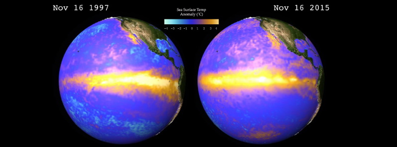
Image credit: NCAR / CISL
Australian Bureau of Meteorology (BOM) reports that a number of El Niño-Southern Oscillation (ENSO) indicators suggest the 2015-16 El Niño has peaked in recent weeks.
"Tropical Pacific Ocean temperatures suggest this event is one of the top three strongest El Niño events of the past 50 years," the Bureau says. Additionally, climate models suggest the 2015-16 El Niño will decline during the coming months, with a return to ENSO neutral likely during the second quarter of 2016.
In the central to eastern tropical Pacific Ocean, the sea surface and sub-surface have cooled in recent weeks, though temperatures remain at strong El Niño levels.

Monthly sea surface temperatures in the tropical Pacific. Image credit: BOM
| Index | October | November | Temperature change |
|---|---|---|---|
| NINO3 | +2.4 | +2.4 | no change |
| NINO3.4 | +2.4 | +2.3 | 0.1 °C cooler |
| NINO4 | +1.7 | +1.6 | 0.1 °C cooler |
Baseline period 1961–1990.
In the atmosphere, the Southern Oscillation Index has eased to weak El Niño values. Recent bursts of westerly winds over the equatorial western Pacific may temporarily slow the decline of El Niño.
Based on the 26 El Niño events since 1900, around 50% have been followed by a neutral year, while 40% have been followed by La Niña.
All of the eight international climate models surveyed by the Bureau indicate that the current El Niño will show a steady decline from early 2016. Models also suggest neutral and La Niña are equally likely for the second half of 2016, with a repeat El Niño the least likely outcome.

Video courtesy NCAR/CISL
Indian Ocean sea surface temperatures remain very much warmer than average across the majority of the basin.

The Watchers team and our contributors bring the latest on extreme weather, earthquakes, volcanic eruptions, space weather, and all things science. We're all about making sense of the natural world and keeping you informed on what’s happening. Got a tip or a question? Hit us up using the form at newstips!
Earlier reporting
Nothing on Watchers was published in the last 24 hours. These are older articles.
- On October 22, 2017, a single flash of lightning stretched 515 miles from eastern Texas to near Kansas City, a distance that takes eight hours to drive, and nobody realized how far it had gone until scientists went back through the satellite data years later Epicenter
- CPC posts a slight risk of heavy rain from the Gulf Coast to the Northeast urban corridor November 25-29, and a moderate risk of West Coast wind and Sierra snow on November 25
- Florida's east coast faces a moderate flash flood risk Wednesday through Friday, with 4 to 8 inches of rain forecast and the St. Johns River near Cocoa already in major flood at 17.13 feet
- Cyclone Akvan to make landfall between Nellore and Visakhapatnam around noon on November 20, IMD forecasts 120-130 km/h winds gusting to 145
