
Typhoon “Chan-hom” to become major storm system on course toward Okinawa and mainland China
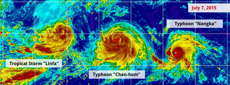
Image credit: UW-CIMSS. Annotation: The Watchers.
Tropical Storm "Chan-hom" formed last week east of Guam, passed through the Rota channel bringing heavy rain to both Guam and Rota islands and reached typhoon strength during the UTC afternoon of July 6, 2015. The system is expected to become a major typhoon on its way toward Miyako and Okinawa, Japan and mainland China.
During the early UTC hours of July 5, 2015, Chan-hom passed between Guam and Rota with maximum sustained winds between 83.3 to 92.6 km/h (51.7 to 57.5 mph) bringing heavy rain and causing significant damage to both islands. The storm then moved on toward the Northern Marianas Islands and mainland China.
Chan-hom is intensifying and is expected to resume WNW to NW trajectory and strengthen into a major typhoon with maximum sustained wind speeds of 240.7 km/h (149.6 miles) by July 9.
At 09:00 UTC on July 7, JTWC said Typhoon "Chan-hom" was located approximately 880 km (547 miles) SW of Iwo To, tracking WNW at 16.6 km/h (10.3 mph). Its maximum sustained winds at the time were 148 km/h (92 mph).
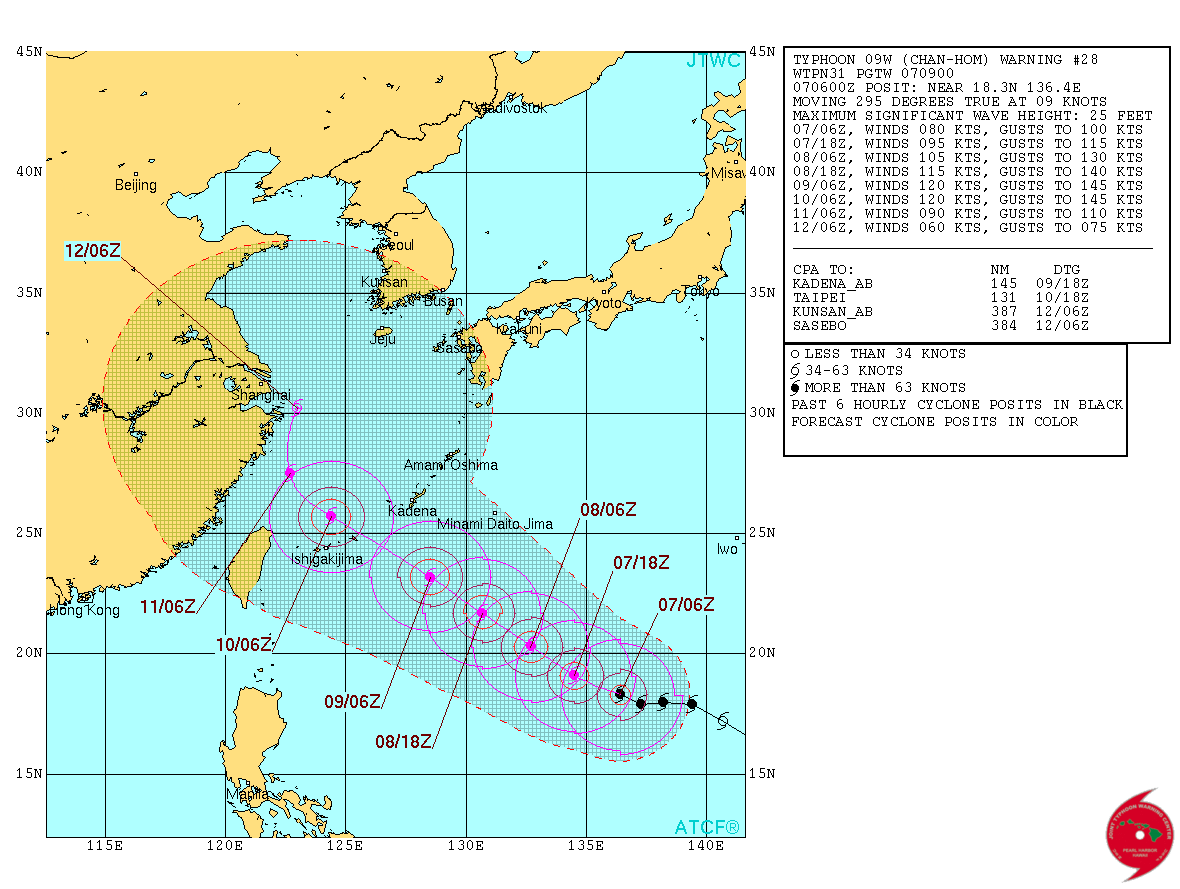
Typhoon "Chan-hom" forecast track on July 6, 2015. Image credit: JTWC/ATCF.
Forecast video by meteorologist Robert Speta of the WestPacWx.
The Atmospheric Infrared Sounder or AIRS instrument that flies aboard NASA's Aqua satellite gathered infrared temperature data on Chan-Hom when it was still a tropical storm on July 6 at 04:29 UTC.
The coldest thunderstorm cloud tops measured were near -63 Fahrenheit or -52 Celsius. Cloud top temperatures that cold are high into the troposphere and capable of generating heavy rain.
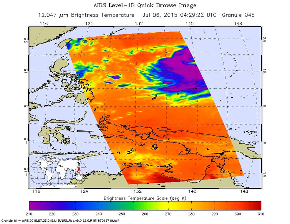
The AIRS instrument aboard NASA's Aqua satellite gathered infrared temperature data on Chan-Hom when it was a Tropical Storm on July 6 at 04:29 UTC (12:29 a.m. EDT). Purple areas indicate the coldest cloud tops and strongest thunderstorms within. Credits: NASA JPL, Ed Olsen
Between 09:00 UTC and 15:00 UTC on July 6, Chan-hom's maximum sustained winds increased from 111 km/h (69 mph) to 120 km/h (75 mph) bringing it to typhoon strength. It was centered about 1 527 km (950 miles) SE of Kadena Air Force Base, Guam. Chan-Hom has tracked WNW at 26 km/h (16 mph).
The JTWC forecasts the storm to continue to strengthen over the next three days and expected to peak as a Category 4 typhoon on the Saffir-Simpson Wind Scale, with maximum sustained winds nearing 240.8 km/h (149.6 mph). The storm is forecast to pass between Ishigakjima and Kadena islands on July 9 before making landfall in eastern China as a typhoon.
Chan-hom is closely followed by Typhoon "Nangka" currently located east of Guam. Meanwhile, Tropical Storm "Linfa" is now approaching Taiwan.
.GIF)
Tropical Storm "Linfa" (left), Typhoon "Chan-hom" (center) and Typhoon "Nangka" (right). Image credit: UW-CIMSS.
I'm a dedicated researcher, journalist, and editor at The Watchers. With over 20 years of experience in the media industry, I specialize in hard science news, focusing on extreme weather, seismic and volcanic activity, space weather, and astronomy, including near-Earth objects and planetary defense strategies. You can reach me at teo /at/ watchers.news.
Commenting rules and guidelines
We value the thoughts and opinions of our readers and welcome healthy discussions on our website. In order to maintain a respectful and positive community, we ask that all commenters follow these rules.