
Tropical Storm “Linfa” (Egay) to hit northern Luzon, Philippines late July 4
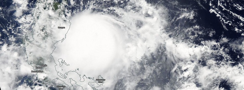
Featured image: Tropical Storm "Linfa" (Egay) on July 4, 2015. Image credit: NASA Aqua/MODIS.
Tropical Storm "Linfa" (Egay) formed east of the Philippines on July 1, 2015, intensified and is expected to make landfall over northern Luzon, an area which gets frequently hit by typhoons, late July 4 through early July 5. Heavy rain, flash floods and landslides present the biggest threat from this system.
At 03:00 UTC on July 4, 2015, Tropical Storm "Linfa" was located 280 km (174 miles) NE of Baler, Aurora moving NW at 13 km/h (8 mph). Maximum sustained winds at the time were 85 km/h (52.8 mph) near the center and gustiness of up to 100 km/h (62 mph).
Over the next 24 hours, PAGASA expects Linfa's center about 90 km (56 miles) ESE of Aparri, Cagayan or over the eastern coast of Cagayan.
Estimated rainfall amount is from moderate to occasionally heavy within the 400 km (248 miles) diameter of the tropical storm.

Fisher folk and small sea crafts are advised not to venture out over the seaboards of southern Luzon and Visayas and the northern seaboard of Mindanao.
Residents in mountainous and low lying areas of Metro Manila, MIMAROPA, CALABARZON and Bicol Region are alerted against possible flashfloods and landslides.


Tropical Storm "Linfa" forecast track by JTWC on July 4, 2015.
JTWC noted at 03:00 UTC on July 4, it expects Linfa to remain on a WNW trajectory over the next 48 hours. Modest intensification to 102 km/h (63.3 mph) due to favorable sea surface temperatures and ocean heat content is expected.
After it makes landfall in northern Luzon the system will begin weakening and re-emerge over water as a weak tropical storm. Beyond the next 48 hours, Linfa will turn to the north and intensify slightly.

Tropical Storm "Linfa" (Egay) on July 4, 2015. Image credit: NASA Aqua/MODIS.
Satellite animations
- Storm-Centered Infrared (MTSAT2; NOAA/SSD)
- Storm-Centered Infrared (Aviation Color Enhancement) (MTSAT2; NOAA/SSD)
- Storm-Centered Water Vapor (MTSAT2; NOAA/SSD)
- Storm-Centered Visible (MTSAT2; NOAA/SSD)
- Storm-Centered Visible (Colorized) (MTSAT2; NOAA/SSD)
- Storm-Centered Infrared (MTSAT2; CIMSS)
- Storm-Centered Enhanced Infrared (MTSAT2; CIMSS)
- Storm-Centered Water Vapor (MTSAT2; CIMSS)
- Storm-Centered Visible (MTSAT2; CIMSS)
- South China Sea/West Pacific Infrared (MTSAT2; NOAA)
- South China Sea/West Pacific Enhanced Infrared (MTSAT2; NOAA)
- South China Sea/West Pacific Water Vapor (MTSAT2; NOAA)

Teo Blašković founded The Watchers in 2011 and edited it until 2026, covering seismic and volcanic activity, extreme weather, space weather and near-Earth objects. Articles on this page are his archive.
Earlier reporting
Nothing on Watchers was published in the last 24 hours. These are older articles.
- Cyclone Akvan to make landfall between Nellore and Visakhapatnam around noon on November 20, IMD forecasts 120-130 km/h winds gusting to 145
- Bay of Bengal system to become Cyclone Akvan, landfall forecast between Nellore and Tuni on November 20, India
- Tropical Cyclone Xavier reaches Category 2 over Northern Cook Islands, gale warning for Manihiki and Rakahanga
- On October 22, 2017, a single flash of lightning stretched 515 miles from eastern Texas to near Kansas City, a distance that takes eight hours to drive, and nobody realized how far it had gone until scientists went back through the satellite data years later Epicenter



