
El Niño threshold reached in tropical Pacific
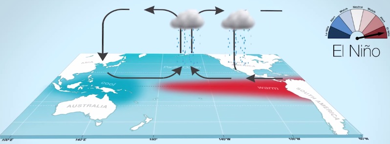
Image credit: Australian Bureau of Meteorology
Today's update on the El Niño–Southern Oscillation (ENSO) by Australian Bureau of Meteorology confirms El Niño thresholds have been reached in the tropical Pacific for the first time since March 2010.
Assistant Director for Climate Information Services, Mr Neil Plummer, said El Niño is often associated with below average rainfall across eastern Australia in the second half of the year, and warmer than average daytime temperatures over the southern half of the country.
“The onset of El Niño in Australia in 2015 is a little earlier than usual. Typically El Niño events commence between June and November,” Mr Plummer said.
“Prolonged El Niño-like conditions have meant that some areas are more vulnerable to the impact of warmer temperatures and drier conditions.

“The failed northern wet season in 2012–13, compounded by poor wet seasons in 2013-14 and 2014-15, have contributed to drought in parts of inland Queensland and northern New South Wales,” he said.
Mr Plummer noted that while the El Niño is forecast to strengthen during winter, the strength of an El Niño does not necessarily correspond with its impact on Australian rainfall. Australia experienced widespread drought during a weak El Niño in 2006–07, while stronger events such as the El Niño event in 1997–98 had only a modest impact on Australian rainfall.

“Recent significant rainfall and flooding along the east coast of Australia, associated with two almost back-to-back East Coast Lows, did not penetrate far into inland regions and therefore have done little to alleviate conditions in drought affected areas,” Mr Plummer said.
While El Niño increases the risk of drought, it does not guarantee it; of the 26 El Niño events since 1900, 17 have resulted in widespread drought.
Despite El Niño increasing the likelihood of drier conditions later this year, the Bureau’s May to July Climate Outlook indicates much of Australia is likely to be wetter than average.
This is being driven by warmer than average Indian Ocean sea surface temperatures, which are dominating this outlook.
- ENSO Wrap-Up: bom.gov.au/climate/enso/

Teo Blašković founded The Watchers in 2011 and edited it until 2026, covering seismic and volcanic activity, extreme weather, space weather and near-Earth objects. Articles on this page are his archive.
Earlier reporting
Nothing on Watchers was published in the last 24 hours. These are older articles.
- On October 22, 2017, a single flash of lightning stretched 515 miles from eastern Texas to near Kansas City, a distance that takes eight hours to drive, and nobody realized how far it had gone until scientists went back through the satellite data years later Epicenter
- CPC posts a slight risk of heavy rain from the Gulf Coast to the Northeast urban corridor November 25-29, and a moderate risk of West Coast wind and Sierra snow on November 25
- Florida's east coast faces a moderate flash flood risk Wednesday through Friday, with 4 to 8 inches of rain forecast and the St. Johns River near Cocoa already in major flood at 17.13 feet
- Cyclone Akvan to make landfall between Nellore and Visakhapatnam around noon on November 20, IMD forecasts 120-130 km/h winds gusting to 145
