
Typhoon “Nuri” makes extra-tropical transition
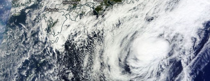
Featured image: Tropical Storm "Nuri" on November 6, 2014. Image credit: NASA Terra/MODIS
According to JTWC's warning issued 03:00 UTC today, Nuri – the sixth super typhoon of 2014 – has now nearly completed its extra-tropical transition and is located approximately 240 km (149 miles) west-northwest of Chichi Jima, Japan. The system is expected to be a strong extra-tropical low given the good upper level jet support.
Nuri's maximum sustained winds at 06:00 UTC today were 101 km/h (63 mph), wind gusts were 129 km/h (80 mph).
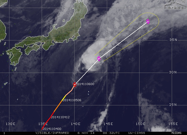
Tropical Storm "Nuri" on November 6, 2014. Image credit: UW-CIMSS
Tropical Storm "Nuri" formed in the Philippine Sea on Friday, October 31, intensified into a typhoon the next day and started its rapid intensification phase. On Sunday, November 2, JTWC said Nuri had reached super typhoon strength with maximum 1-minute sustained wids of 289 km/h (180 mph).
This made Nuri almost comparable to last month's Vongfong. On JMA scale, Nuri became the fourth violent typhoon of 2014. It had 10-minute average winds of 193 km/h (120 mph) and estimated minimum central pressure of 910.
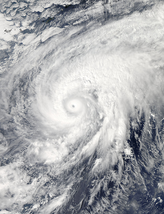
On November 3 at 04:20 UTC NASA's Aqua satellite captured this image of Super Typhoon "Nuri" after it developed an eye. Image credit: NASA Goddard MODIS Rapid Response Team
By 15:00 UTC on Wednesday, November 5, Nuri's maximum sustained winds had dropped to 148.2 km/h (92 mph) as a result of increased wind shear. At the time, Nuri was centered about 322 km (200 miles) northwest of Iwo To, Japan and moving to the northeast at 18.5 km/h (11.5 mph).
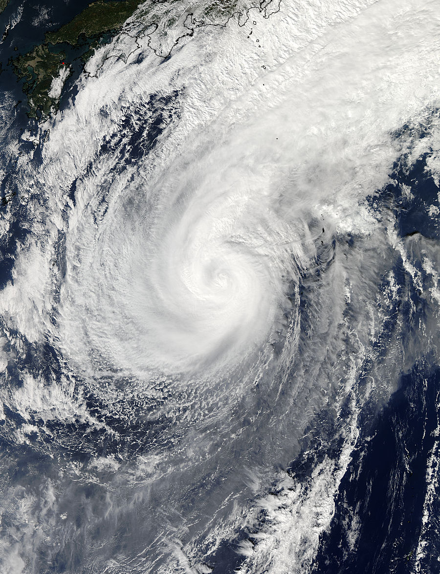
NASA's Aqua satellite captured a visible picture of Typhoon Nuri on November 5 at 4:10 UTC. Image credit: NASA Goddard MODIS Rapid Response Team
Nuri is expected to continue weakening as it moves in a northeasterly direction, while remaining over open waters in the western North Pacific, but is being closely monitored for signs of regeneration.
Satellite animations
- Storm-Centered Infrared (MTSAT2; NOAA/SSD)
- Storm-Centered Infrared (Aviation Color Enhancement) (MTSAT2; NOAA/SSD)
- Storm-Centered Water Vapor (MTSAT2; NOAA/SSD)
- Storm-Centered Visible (MTSAT2; NOAA/SSD)
- Storm-Centered Visible (Colorized) (MTSAT2; NOAA/SSD)
- Storm-Centered Infrared (MTSAT2; CIMSS)
- Storm-Centered Enhanced Infrared (MTSAT2; CIMSS)
- Storm-Centered Water Vapor (MTSAT2; CIMSS)
- Storm-Centered Visible (MTSAT2; CIMSS)
- Tropical West Pacific Infrared (MTSAT2; NOAA)
- Tropical West Pacific Enhanced Infrared (MTSAT2; NOAA)
- Tropical West Pacific Water Vapor (MTSAT2; NOAA)
- Tropical West Pacific Visible (MTSAT2; NOAA)
I'm a dedicated researcher, journalist, and editor at The Watchers. With over 20 years of experience in the media industry, I specialize in hard science news, focusing on extreme weather, seismic and volcanic activity, space weather, and astronomy, including near-Earth objects and planetary defense strategies. You can reach me at teo /at/ watchers.news.
Commenting rules and guidelines
We value the thoughts and opinions of our readers and welcome healthy discussions on our website. In order to maintain a respectful and positive community, we ask that all commenters follow these rules.