
Remnants of Super Typhoon “Nuri” affecting Aleutian Islands, Alaska
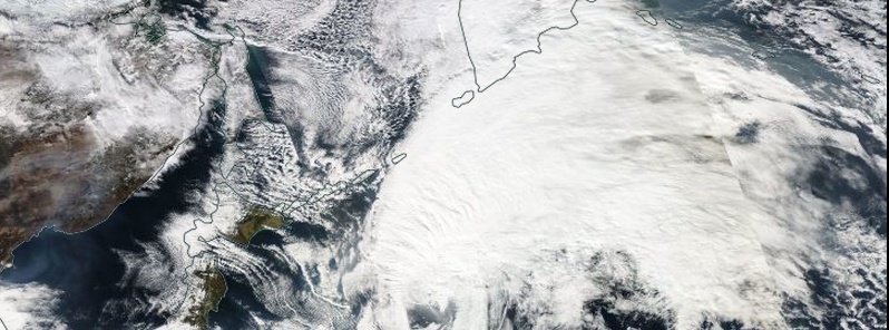
Featured image: Nuri's remnants on November 7, 2014. Image credit: NASA Aqua/MODIS
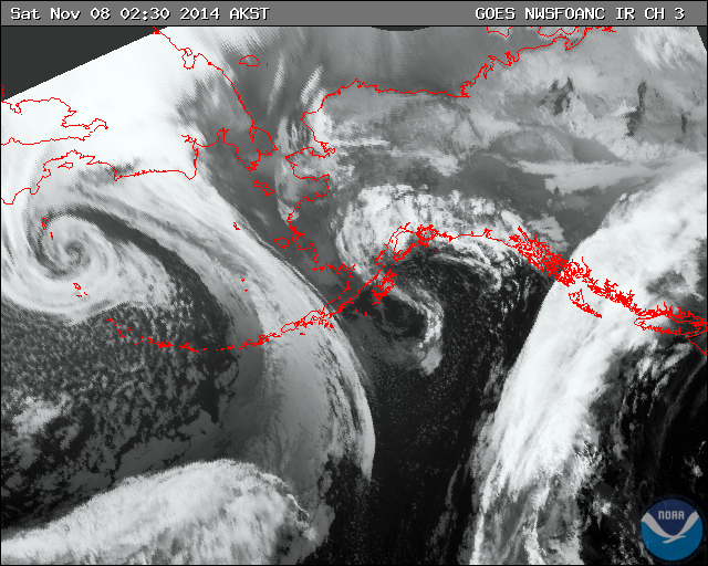
Remnants of Super Typhoon "Nuri" have moved across the Pacific and are now bringing hurricane-force wind gusts to Western Aleutian Islands, Alaska. What's left of Nuri has combined with polar jet and on November 8th became the strongest low-pressure system ever observed in or near Alaska since October 25, 1977. The system is expected to bring frigid temperatures to much of the U.S. and Canada next week.
National Weather Service Office in Anchorage, Alaska issued a High Wind Warning for the Western Aleutian Islands including the cities of Shemya and Amchitka on Friday, November 7, 2014. The warning is valid from 18:00 UTC today to 18:00 UTC on Saturday, November 8 (09:00 AM AKST until November 8, 09:00 AM AKST).
The warning states that the southwest winds 32 – 56 km/h (20 – 35 mph) early on November 7 will rapidly increase to south 86 – 120 km/h (60 – 75 mph) with gusts of 128 – 144 km/h (80 – 90 mph) by late morning. During the afternoon and evening winds will shift to the southwest and continue through Saturday morning before slowly diminishing. Any travel may be difficult. Loose debris can be moved and damage property.
A high wind warning means a hazardous high wind event is expected or occurring. People are urged to secure loose objects that could be blown around or damaged by the wind.
The most powerful storm ever developed over the Bering Sea in recorded history, in terms of central pressure
AccuWeather.com meteorologists said on November 7 they believe that this system could become one of the most intense storms to move over the Bering Sea.
"The central pressure of this system is forecast to drop below 930 millibars on Friday night. To put this in perspective, the lowest pressure recorded in Hurricane Sandy was 940 millibars. If the pressure of this storm does drop this low, it will be in contention for becoming one of the most powerful storms to ever develop over the Bering Sea in recorded history in terms of central pressure. The current record stands at 925 millibars from a powerful storm that moved over the Bering Sea on October 25, 1977."
And they were right.
At 06:00 UTC on November 8, 2014 ex-Nuri's central pressure was 924 mb! This made it the strongest low-pressure system ever observed in or near Alaska since October, 1977.
at 06Z OPC analyzed PT #Nuri to 924mb, eclipsing previous recorded low pressure of 925 mb at Dutch Harbor in Oct '77 pic.twitter.com/6wJtb7vNDi
— NWS OPC (@NWSOPC) November 8, 2014
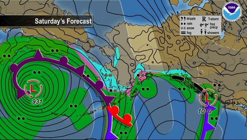
FXAK68 PAFC 080210
AFDAFC

SOUTHCENTRAL AND SOUTHWEST ALASKA FORECAST DISCUSSION
NATIONAL WEATHER SERVICE ANCHORAGE AK
510 PM AKST FRI NOV 7 2014

.ANALYSIS AND UPPER LEVELS...
SOUTHWEST BERING UPPER LOW AT 500 MB WILL BECOME THE DEEPEST IN
THE HEMISPHERE FRIDAY NIGHT (479) DUE TO THE BIG PRESSURE FALLS AT
THE SURFACE. UPPER TROF KODIAK ISLAND LIFTS NORTHWARD SATURDAY
WHILE THE ASSOCIATED SURFACE LOW WEAKENS AND SLIDES NORTHWARD JUST
EAST OF THE ISLAND TONIGHT. THAT LOW WILL MAKE LANDFALL ON THE
KENAI PENINSULA COAST WEST OF RESURRECTION BAY MIDDAY OR EARLY
AFTERNOON SATURDAY. BY SUNDAY MORNING A SOUTHERLY JET WILL HAVE
SET UP ALONG 155W BETWEEN THE DEEP SOUTHCENTRAL BERING UPPER LOW
AND A BUILDING RIDGE ALONG 140W. THIS PATTERN IS KNOWN FOR ITS
PERSISTENCE AND PROBABLY WILL LINGER FOR AT LEAST 4 OR 5 DAYS
KEEPING TEMPERATURES ABOVE NORMAL AND SNOWFALL BELOW.

&&

.MODEL DISCUSSION...ALL FOUR FORECASTERS DECIDED TO USE THE EC HIGH
RESOLUTION MODEL DUE TO BETTER CONSISTENCY, INTENSITY AND TRACK.
THROUGH 72 HOURS THE DIFFERENCES BETWEEN THE BETWEEN THE TWO ARE
NOT TOO GREAT AND EVEN NONEXISTENT IN AREAS.

&&

.SHORT TERM FORECAST SOUTHCENTRAL ALASKA (DAYS 1 AND 2)...
LAST NIGHTS FRONT DID NOT DISAPPOINT. STORM FORCE WINDS WERE
OBSERVED ACROSS MUCH OF THE NORTHERN GULF OF ALASKA ALL THE WAY
DOWN THROUGH THE BARREN ISLANDS. EVEN THE PRINCE WILLIAM SOUND HAD
A GUST TO 47KT. THE UPPER LEVEL THAT HELPED TO PUSH THAT FRONT
ACROSS THE AREA CONTINUES TO SPIN SOUTH OF KODIAK ISLAND. IT WILL
CONTINUE TO LIFT WEAK WAVES FROM THE SOUTH GULF TO THE COAST
TONIGHT AND EARLY SATURDAY. THESE WAVES WILL CAUSE THE GUSTY
NORTHEAST TO SOUTHEAST WINDS AND HEAVIER PRECIP TO EBB AND FLOW.

ON SATURDAY...AS THE MONSTER OVER THE BERING SLOWLY PROGRESSES
EASTWARD...IT WILL DO A FEW THINGS. FIRST...IT WILL GIVE ENOUGH OF
A PUSH TO THE PREVIOUSLY MENTIONED UPPER LEVEL LOW TO DRIFT
THROUGH SOUTH CENTRAL. AS THAT LOW MOVES THROUGH IT SHOULD BRING A
SLIGHTLY ENHANCED CHANCES FOR PRECIPITATION LATE SATURDAY INTO
SUNDAY AS THE DOWNSLOPING WINDS SHUT OFF. IT WILL THEN SEND A
SURGE OF ABOUT 10C DEGREES IN THE MID LEVELS FORWARD UNDERNEATH
THE NORTH AMERICAN RIDGE. THIS WILL SERVE TO DRAMATICALLY BUILD
THIS RIDGE UP NORTH OF THE NORTH SLOPE. THIS WILL PUT SOUTHCENTRAL
UNDER DEEP AND RATHER STRONG SOUTHERLY FLOW TOWARDS EARLY NEXT
WEEK. THE MAIN FRONT ASSOCIATED WITH NURI REMNANTS WILL RIDE THIS
FLOW TOWARD THE COAST LATE SUNDAY. AS FOR NOW...IT LOOKS LIKE
PRECIPITATION WILL BE HEAVIEST FOR COASTAL AREAS ONCE AGAIN WITH
DOWNSLOPING WINDS "PROTECTING" INLAND LOCATIONS. IT WILL CAUSE THE
TYPICAL SPOTS...TURNAGAIN ARM...THOMPSON PASS...KACHEMAK BAY...TO
BLOW. THE MAT-SU VALLEY COULD ALSO SEE AN INCREASE IN NORTHEAST
WINDS LATE SUNDAY.

&&

.SHORT TERM FORECAST SOUTHWEST ALASKA (DAYS 1 AND 2)...
SCATTERED RAIN AND SNOW SHOWERS OVER THE BRISTOL BAY AREA CONTINUE
TO TAPER OFF THIS EVENING...WITH MOST OF THE RAIN ALONG THE
ALASKA PENINSULA AND PRIMARILY SNOW ELSEWHERE. THE REST OF THE
SOUTHWEST WILL REMAIN RELATIVELY DRY...EXCEPT FOR SOME LINGERING
ISOLATED SNOW SHOWERS AROUND THE EASTERN PART OF THE KUSKOKWIM
DELTA AND SCATTERED SNOW SHOWERS EAST OF SLEETMUTE TONIGHT.
MOVING INTO THE WEEKEND PRECIPITATION AROUND BRISTOL BAY WILL
LIGHTEN UP UNTIL A FRONT MOVES IN FROM THE WEST SATURDAY AFTERNOON.
THIS FRONT WILL BRING WARMER AIR THROUGHOUT THE SOUTHWEST WHICH
WILL BRING THE RAIN LINE FURTHER NORTH IN BRISTOL BAY. THE
KUSKOKWIM DELTA AND LOWER KUSKOKWIM VALLEY WILL ALSO SEE SOME SNOW
FROM THIS SYSTEM THAT WILL START TO MIX WITH RAIN AS MORE WARM
AIR PUSHES IN FROM THE SOUTH.

&&

.SHORT TERM FORECAST BERING SEA/ALEUTIANS (DAYS 1 AND 2)...
RAIN AND SNOW SHOWERS OVER THE EASTERN ALEUTIANS HAVE TAPERED OFF
WITH WEAK RIDGING FROM THE WEST QUICKLY PASSING THROUGH THE
EASTERN ALEUTIANS TONIGHT. RAIN AND GUSTY WILL PICK UP AGAIN FROM
WEST TO EAST AFTER MIDNIGHT...AS THE FRONT ASSOCIATED WITH THE
EXTRATROPICAL CYCLONE OUT WEST CONTINUES TOO TRACK EASTWARD.
FURTHER OUT WEST...THE LOW NORTHWEST OF SHEMYA WILL SLOWLY TRACK
TOWARD THE CENTRAL BERING BY LATE SUNDAY MORNING...CONTINUING TO
BRING RAIN AND GUSTY WINDS TO THE WESTERN AND CENTRAL ALEUTIANS
THROUGH SUNDAY. WARNING LEVEL WINDS ARE EXPECTED TO PICKUP AGAIN
TONIGHT OVER THE WESTERN ALEUTIANS AND PERSIST THROUGH TOMORROW
MORNING...THEN SLOWLY DIMINISH AS THE LOW PROGRESSES EASTWARD.

&&

.LONG TERM FORECAST (SUNDAY NIGHT THROUGH THURSDAY NIGHT)...

THE CLOSED UPPER LOW OVER THE CENTRAL BERING WILL REMAIN STATIONARY
SUNDAY NIGHT THROUGH MONDAY AND THEN ELONGATE AS A RIDGE BUILDS OVER
EASTERN ALASKA. AT THE SURFACE...THE FRONT ACROSS THE SOUTHWEST AND
WESTERN GULF WILL CONTINUE TO MOVE NORTHEAST. WITH A GENERAL
SOUTHEAST FLOW NEAR THE SURFACE...THE GULF COASTAL LOCATIONS WILL
SEE THE HIGHEST PRECIPITATION AMOUNTS WITH ISOLATED TO SCATTERED
SHOWERS INLAND. PRECIPITATION TYPE WILL BE A MIX OF RAIN AND SNOW
ACROSS THE SOUTHWEST SUNDAY NIGHT INTO MONDAY. WITH A WARMER AIRMASS
MOVING INTO THE SOUTHERN MAINLAND BEHIND THE FRONT...SOUTHCENTRAL
WILL SEE RAIN AND SNOW MIXES. GULF COASTAL LOCATIONS CONTINUE WITH
RAIN AS ANOTHER SURGE OF WARM AIR MOVES UP THROUGH THE GULF ON
TUESDAY. THE COPPER RIVER VALLEY REMAINS COLD ENOUGH TO STAY SNOW
UNTIL THE NEXT WARM AIR MASS SURGES NORTH ON WEDNESDAY BRINGING A
CHANCE FOR A MIXED RAIN AND SNOW.
Arctic outbreak
An Arctic outbreak will bring the coldest air of the season, beginning Monday in the northern Rockies and northern Plains. The cold this time will last longer and will be more widespread than other cold surges we have seen so far this season.
Temperatures will remain below average for the central and eastern U.S. at least through the end of next week. (Weather.com)
ISS-RapidScat measurements
NASA's newest Earth observing mission, the International Space Station-Rapid Scatterometer, or ISS-RapidScat provided a look at the winds within post-tropical cyclone Nuri on November 5 and 6 as it moved parallel to Japan.
RapidScat measured Nuri's wind speeds twice on November 5 and saw strongest winds, as fast as 30 meters per second (108 km/h/67.1 mph), appeared in the northwestern and southeastern quadrants. On November 6, RapidScat showed sustained wind speeds around the center of circulation had decreased to near 20 meters per second (72 km/h/44.7 mph). (Goddard)
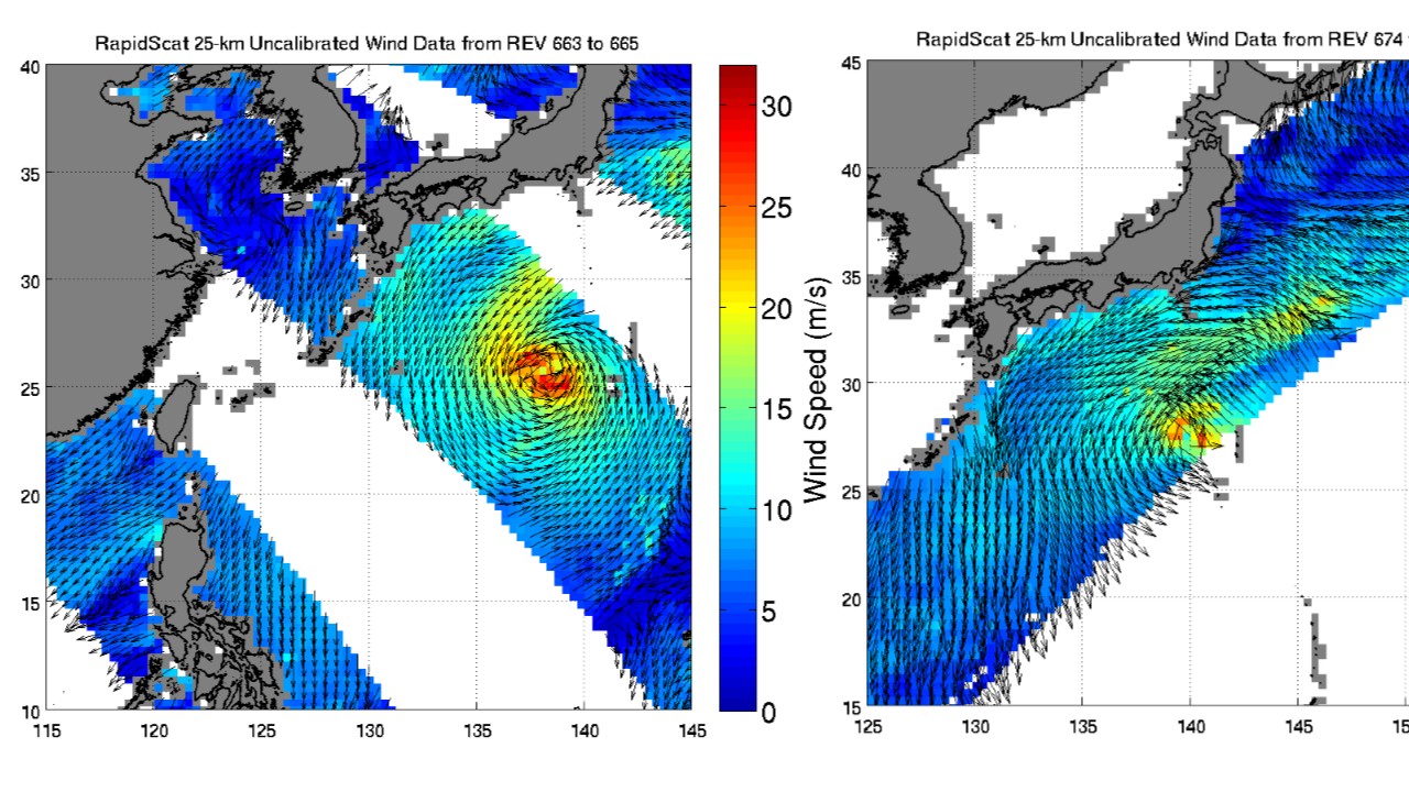
These two images of Nuri's sustained winds were taken by Rapidscat on November 5. Strongest winds (red) as fast as 30 meters per second (108 km/h/67.1 mph) appeared in the northwestern and southeastern quadrants. Image credit: NASA JPL
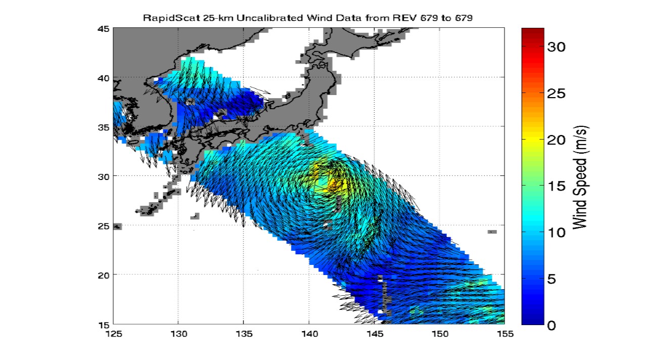
On November 6, Rapidscat showed Nuri's sustained wind speeds around the center of circulation were near 20 meters per second (72 km/h/44.7 mph) (yellow). Image credit: NASA JPL
Tropical Storm "Nuri" formed in the Philippine Sea on Friday, October 31, intensified into a typhoon the next day and started its rapid intensification phase. On Sunday, November 2, Nuri reached super typhoon strength with maximum 1-minute sustained wids of 289 km/h (180 mph).
This made Nuri almost comparable to last month's Vongfong.
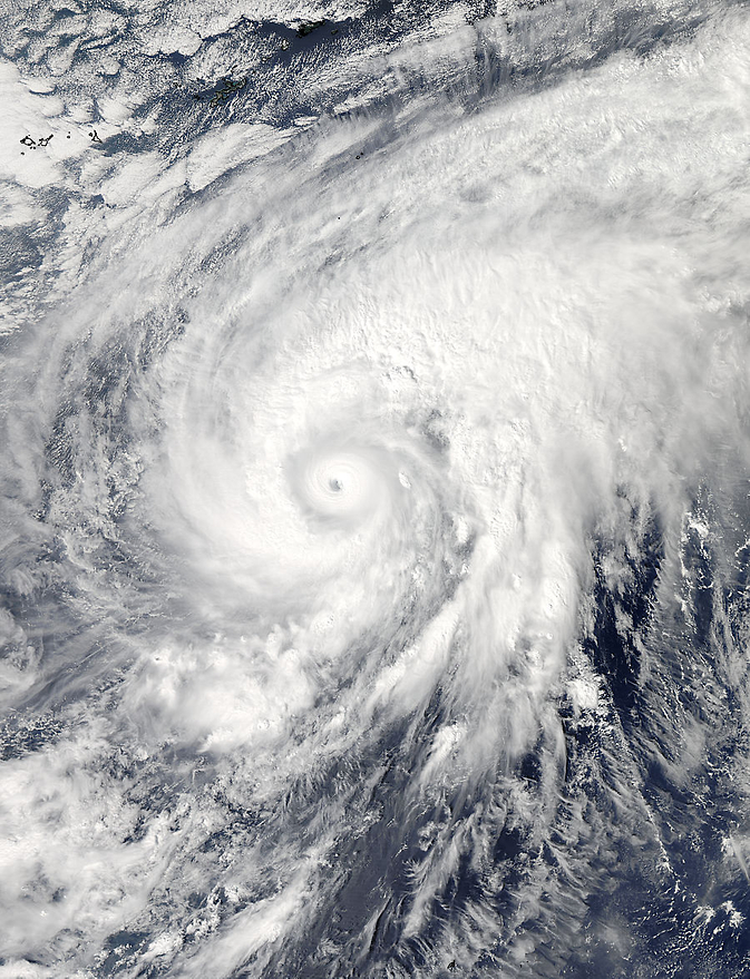
On November 3 at 04:20 UTC NASA's Aqua satellite captured this image of Super Typhoon "Nuri" after it developed an eye. Image credit: NASA Goddard MODIS Rapid Response Team
I'm a dedicated researcher, journalist, and editor at The Watchers. With over 20 years of experience in the media industry, I specialize in hard science news, focusing on extreme weather, seismic and volcanic activity, space weather, and astronomy, including near-Earth objects and planetary defense strategies. You can reach me at teo /at/ watchers.news.
Spiral Power…..in full effect
Now we have some actual weather systems in play to see how so called”global warming” works.It appears that when a strong tropical storm meets the Arctic air masses it does join;but forms a “polar vortex”which will now cool significant portions of North America.
Where did all of that enormous heat go??It does seem that if a large active warm air mass encounters the Arctic air,NO warming but extreme cooling results…, so how exactly would warming ensue on a small scale??