
Earthquake swarm in northwest Nevada intensifies, USA
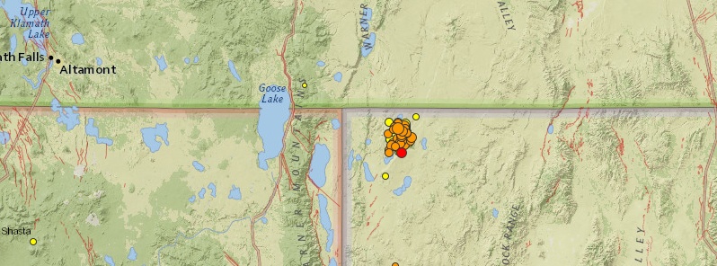
Image credit: USGS
An intense swarm of earthquakes is shaking sparsely populated region of northwest Nevada, USA since July 12, 2014. Authorities report the swarm has become much more active in the past few days.
During the past three months the Nevada Seismological Laboratory (NSL), in collaboration with the USGS and seismic networks in Washington and Oregon, has recorded 42 earthquakes larger than Magnitude 3, and about 550 earthquakes larger than Magnitude 2.
Four Magnitude 4+ events have occurred in last 7 days (since October 30) with the strongest being M4.7 registered at 00:34 UTC today at depth of 5.3 km (3.3 miles). Epicenter was located 68 km (42 miles) ESE of Lakeview and 177 km (110 miles) ESE of Altamont, Oregon.
The second strongest was registered at 07:23 UTC on Wednesday, November 5. That one measured M4.6 and had depth of 0.1 km, according to USGS.
129 earthquakes were registered during the same period (October 30 – November 6), with 64 of them on November 5. See the map and a complete list below.
According to University of Nevada's NSL, this activity resembles the 1968 Adel, Oregon, swarm, which also lasted several months and included three events of approximately Magnitude 5; the Adel swarm caused moderate damage. Another analog is the 2008 “Mogul-Somersett” swarm in west Reno. This swarm also consisted of an increasingly vigorous series of earthquakes over a two-month period, leading to a Magnitude 5 event. The Mogul sequence also caused moderate local damage.
"Following any sequence of earthquakes similar to what is occurring in northwest Nevada, there is a small increase in the probability of a larger event. Whether a larger event will occur in the northwest Nevada swarm cannot be predicted or forecast. However, large earthquakes can happen anywhere in Nevada, and we encourage citizens to take steps to prepare for the potential for strong ground shaking." (NSL)
Note: Updates are posted at the end of the article.
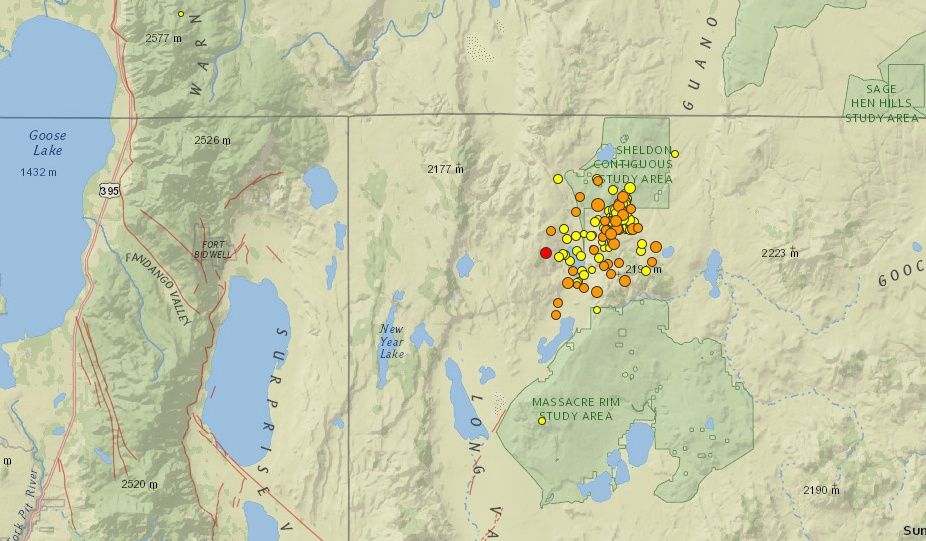
Map showing 129 earthquakes since October 30, 2014. Image credit: USGS
- 3.62014-11-06 12:15:36 UTC0.2 km
- 4.72014-11-06 08:34:46 UTC5.3 km
- 3.72014-11-06 08:00:00 UTC4.4 km
- 2.22014-11-06 03:18:10 UTC4.1 km
- 2.52014-11-06 03:15:09 UTC2.7 km
- 2.32014-11-06 03:01:37 UTC0.0 km
- 3.42014-11-06 02:12:47 UTC0.1 km
- 3.72014-11-06 01:21:11 UTC0.0 km
- 3.52014-11-06 01:17:10 UTC0.7 km
- 2.92014-11-05 23:54:38 UTC0.0 km
- 3.32014-11-05 23:01:12 UTC0.1 km
- 2.92014-11-05 22:23:51 UTC0.0 km
- 2.42014-11-05 22:22:17 UTC0.0 km
- 3.52014-11-05 20:06:13 UTC4.0 km
- 2.32014-11-05 19:55:34 UTC0.0 km
- 2.32014-11-05 19:39:53 UTC0.0 km
- 2.42014-11-05 19:28:22 UTC0.0 km
- 2.82014-11-05 18:51:25 UTC0.0 km
- 3.32014-11-05 17:53:24 UTC0.0 km
- 3.12014-11-05 17:18:40 UTC2.5 km
- 2.32014-11-05 16:32:53 UTC13.1 km
- 2.32014-11-05 16:01:43 UTC12.1 km
- 2.82014-11-05 15:50:12 UTC0.0 km
- 2.22014-11-05 15:28:37 UTC0.0 km
- 3.92014-11-05 15:18:26 UTC5.4 km
- 2.32014-11-05 13:51:39 UTC0.0 km
- 3.22014-11-05 13:23:49 UTC0.0 km
- 2.12014-11-05 13:19:41 UTC0.1 km
- 2.12014-11-05 12:55:29 UTC0.0 km
- 3.22014-11-05 12:29:57 UTC0.0 km
- 3.32014-11-05 12:12:50 UTC1.1 km
- 1.82014-11-05 12:07:14 UTC0.5 km
- 1.52014-11-05 12:00:57 UTC0.0 km
- 3.02014-11-05 11:59:08 UTC0.0 km
- 2.12014-11-05 11:38:50 UTC0.1 km
- 2.42014-11-05 11:35:01 UTC0.0 km
- 2.32014-11-05 11:07:55 UTC0.0 km
- 2.22014-11-05 11:02:14 UTC0.0 km
- 2.92014-11-05 10:53:35 UTC1.6 km
- 2.32014-11-05 10:33:27 UTC0.0 km
- 2.82014-11-05 10:29:12 UTC0.0 km
- 3.72014-11-05 10:23:06 UTC0.0 km
- 2.22014-11-05 09:59:51 UTC0.0 km
- 3.42014-11-05 09:51:51 UTC0.1 km
- 2.22014-11-05 09:46:41 UTC0.0 km
- 2.52014-11-05 09:25:54 UTC0.5 km
- 1.92014-11-05 09:20:05 UTC0.0 km
- 1.62014-11-05 09:17:33 UTC14.3 km
- 2.92014-11-05 09:11:38 UTC0.5 km
- 3.22014-11-05 09:07:47 UTC0.0 km
- 3.52014-11-05 09:05:37 UTC0.0 km
- 3.42014-11-05 08:54:56 UTC0.0 km
- 2.12014-11-05 08:42:23 UTC0.0 km
- 2.12014-11-05 08:37:09 UTC0.1 km
- 2.12014-11-05 08:36:19 UTC0.0 km
- 2.52014-11-05 08:34:51 UTC1.3 km
- 3.02014-11-05 08:27:51 UTC1.0 km
- 2.92014-11-05 08:24:38 UTC0.0 km
- 2.72014-11-05 08:21:50 UTC1.2 km
- 2.72014-11-05 08:08:04 UTC0.0 km
- 2.42014-11-05 08:04:05 UTC0.5 km
- 3.02014-11-05 08:00:08 UTC1.0 km
- 2.72014-11-05 07:50:21 UTC0.7 km
- 2.32014-11-05 07:48:30 UTC0.1 km
- 2.22014-11-05 07:39:14 UTC0.1 km
- 2.32014-11-05 07:35:04 UTC0.0 km
- 2.72014-11-05 07:30:25 UTC0.1 km
- 4.62014-11-05 07:23:04 UTC0.1 km
- 2.32014-11-05 07:16:47 UTC0.2 km
- 3.02014-11-05 07:14:46 UTC2.3 km
- 2.32014-11-05 05:29:36 UTC0.0 km
- 3.52014-11-05 04:45:30 UTC0.6 km
- 2.12014-11-05 01:32:48 UTC0.0 km
- 1.32014-11-05 00:53:54 UTC0.3 km
- 2.32014-11-04 23:47:23 UTC0.0 km
- 2.22014-11-04 22:39:24 UTC0.0 km
- 2.82014-11-04 22:20:14 UTC0.0 km
- 3.32014-11-04 21:16:07 UTC0.0 km
- 2.52014-11-04 21:14:21 UTC0.6 km
- 2.82014-11-04 14:25:52 UTC0.0 km
- 2.82014-11-04 13:58:29 UTC0.3 km
- 2.12014-11-04 12:48:58 UTC0.7 km
- 2.52014-11-04 12:07:13 UTC1.6 km
- 2.62014-11-04 11:49:53 UTC0.0 km
- 2.92014-11-04 11:27:46 UTC2.1 km
- 2.52014-11-04 11:19:35 UTC0.3 km
- 2.12014-11-04 11:17:08 UTC0.0 km
- 1.32014-11-04 11:12:48 UTC0.3 km
- 2.32014-11-04 10:59:52 UTC0.1 km
- 2.32014-11-04 10:55:23 UTC0.1 km
- 4.02014-11-04 10:47:58 UTC0.0 km
- 2.12014-11-04 10:36:44 UTC0.0 km
- 2.22014-11-04 10:33:05 UTC0.0 km
- 2.22014-11-04 08:39:17 UTC0.0 km
- 3.02014-11-02 11:58:21 UTC1.0 km
- 1.62014-11-01 10:20:22 UTC4.5 km
- 1.32014-11-01 07:13:44 UTC0.1 km
- 2.42014-11-01 03:23:00 UTC0.0 km
- 1.72014-11-01 03:17:26 UTC2.1 km
- 2.02014-11-01 03:15:53 UTC0.0 km
- 1.02014-10-31 20:57:49 UTC3.1 km
- 2.02014-10-31 20:44:41 UTC0.5 km
- 2.32014-10-31 20:31:05 UTC0.5 km
- 1.72014-10-31 18:08:47 UTC2.5 km
- 1.42014-10-31 15:18:47 UTC0.0 km
- 1.32014-10-31 10:02:09 UTC0.0 km
- 1.82014-10-31 09:24:39 UTC0.0 km
- 1.52014-10-31 09:21:47 UTC0.0 km
- 1.12014-10-31 09:20:56 UTC1.1 km
- 2.02014-10-31 09:19:12 UTC0.0 km
- 1.72014-10-31 06:50:41 UTC0.1 km
- 2.72014-10-31 05:52:08 UTC0.0 km
- 1.52014-10-31 04:10:26 UTC0.5 km
- 2.62014-10-31 03:43:29 UTC0.0 km
- 2.52014-10-31 01:03:06 UTC0.3 km
- 2.22014-10-31 00:54:25 UTC0.0 km
- 2.82014-10-30 17:24:57 UTC0.6 km
- 2.62014-10-30 16:53:44 UTC0.0 km
- 2.42014-10-30 16:33:30 UTC0.0 km
- 2.12014-10-30 16:07:54 UTC0.1 km
- 1.42014-10-30 16:03:16 UTC0.0 km
- 3.12014-10-30 15:50:05 UTC0.6 km
- 1.52014-10-30 15:38:53 UTC4.7 km
- 2.12014-10-30 15:34:10 UTC0.9 km
- 2.52014-10-30 15:28:22 UTC3.1 km
- 2.72014-10-30 15:25:46 UTC0.3 km
- 2.12014-10-30 15:23:57 UTC0.1 km
- 4.12014-10-30 15:16:33 UTC0.0 km
- 0.72014-10-30 13:07:24 UTC6.9 km
Nevada earthquake history
Nevada ranks among the most seismically active States, according to USGS.
A number of the larger shocks have produced some spectacular examples of surface faulting; these include shocks at Pleasant Valley (1915), Cedar Mountain (1932), Excelsior Mountain (1934), Rainbow Mountain (1954), and Fairview Peak – Dixie Valley (1954). Although these events are classied as major earthquakes in terms of magnitude, no fatalities were reported and building damage was minimal because of the sparse population of the epicentral areas.
The earliest reported earthquake in Nevada occurred in 1851. A newspaper article in 1865 cited reports of an earthquake 13 years earlier near Pyramid Lake. The account stated that great cracks opened from which water spouted 100 feet high. Large landslides were also reported.
On October 2, 1915, three strong earthquakes within about 7 hours disturbed a large part of northern Nevada. The third tremor had an estimated magnitude of 7.75. It destroyed or seriously damaged many adobe houses in Pleasant Valley. Most of the damage was confined to the towns of Kennedy, Lovelock, and Winnemucca. The earthquake was felt over a very wide area – from Baker, Oregon, to San Diego, California, and from the Pacific coast to beyond Salt Lake City, Utah, an area of about 1,295,000 square kilometers. A scarp 1.5 to 4.5 meters high and 35 kilometers long, was formed parallel to the base of the Sonoma Mountains. About 100 aftershocks followed the main earthquake.
An earthquake of magnitude 7.3 originated in west-central Nevada on December 20, 1932. The epicentral area, near Cedar Mountain, was almost uninhabited. Two cabins, one of stone, and the other of adobe, were destroyed, and mining property was damaged. Many chimneys were thrown down at Mina and Luning. At Hawthorne, the shock cracked and threw down chimneys. Extensive and complicated faulting occurred northeast of Mina, over an area of about 60 kilometers long and 6 to 14 kilometers wide in the valley between the Cedar and Pilot Mountains. The total felt area was approximately the same as that of the 1915 shock.
About a year later, on January 30, 1934, a magnitude 6.5 earthquake which centered in the Excelsior Mountains area about 80 kilometers west of the 1932 zone, again caused some damage at Mina. The collapse of some adobe buildings at Marietta was also reported. Several foreshocks were noted; the strongest had a magnitude of 5.5 and occurred about an hour before the main earthquake. Slight damage at Mina resulted from this foreshock. A small fault scarp 12.5 centimeters high and about 1,500 meters long was formed on the south slope of the Excelsior Mountains. The earthquake was felt widely over Nevada and in parts of California and Utah, an area of about 285,000 square kilometers.
The Rainbow Mountain area in the Stillwater Range, about 25 kilometers east of Fallon, was the origin of a series of earthquakes in July and August 1954. The first strong earthquake on July 6, magnitude 6.6, was damaging at Fallon; it was followed by a magnitude 6.4 shock about 11 hours later and by a series of smaller aftershocks. Another large earthquake, magnitude 6.8, on August 23 caused additional damaged at Fallon. It too was followed by many aftershocks. Ground breakage was traced for about 40 kilometers.
On December 16, 1954, a major earthquake of magnitude 7.1 occurred about 50 kilometers east of the epicentral region of the July – August shocks, near Frenchman's Station. A magnitude 6.8 aftershock followed 4 minutes later. Intensity X was assigned to the spectacular surface ruptures which occurred in two major fault zones; one on the west side of Dixie Valley along the east base of the Stillwater Range and the other on the east side of Fairview Valley in the Clan Alpine Range. Faulting extended north and south for a linear distance of approximately 90 kilometers. Vertical movement of 1.5 to 4.5 meters was measured in Dixie Valley. About 2 to 6 meters of vertical movement and about 1 to 4 meters of horizontal movement were measured near Fairview Peak. Because the epicentral region was sparsely populated, this potentially destructive earthquake caused relatively little property damage. At Fallon, a few toppled chimneys were noted. Chimneys twisted and fell at Austin. At Sacramento, California, located about 265 kilometers distant, the shock caused an estimated $20,000 damage to a large underground water tank at the city's filtration plant. Some damage was also reported at the city's sewage disposal plant. The shock was felt throughout Nevada and in parts of Arizona, California, Idaho, and Oregon, an area of about 520,000 square kilometers. Again, a long series of aftershocks followed. (USGS)
Update:
USGS recorded a total of 43 earthquakes on November 6, 2014.
By 08:05 UTC on November 7, there were 18 newly registered earthquakes in the same area.
- Real-time earthquake information on this sequence is available at http://www.seismo.unr.edu/Earthquake, and http://earthquake.usgs.gov/earthquakes/map/.
I'm a dedicated researcher, journalist, and editor at The Watchers. With over 20 years of experience in the media industry, I specialize in hard science news, focusing on extreme weather, seismic and volcanic activity, space weather, and astronomy, including near-Earth objects and planetary defense strategies. You can reach me at teo /at/ watchers.news.
Commenting rules and guidelines
We value the thoughts and opinions of our readers and welcome healthy discussions on our website. In order to maintain a respectful and positive community, we ask that all commenters follow these rules.