
Typhoon Wipha strengthened – approaching Honshu and greater Tokyo area
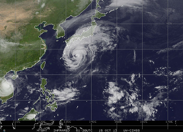
Featured image: MTSAT Infrared satellite image of Typhoon Wipha taken at 01:30 UTC on October 15, 2013 (Credit: NOAA/MTSAT/CIMSS)
Japan is bracing for strong Typhoon Wipha's landfall somewhere around eastern Honshu, including the greater Tokyo area, which is home to more than 35 million people. Island nation can expect destructive winds in addition to life-threatening flooding and mudslides.
According to the Japan Meteorological Agency (JMA), Wipha is now the twelfth typhoon of 2013 and also the 26th named tropical cyclone of the year.

MTSAT visible satellite image of Typhoon Wipha taken at 02:01 UTC on October 15, 2013 (Credit: NOAA/MTSAT)
According to Joint Typhoon Warning Center (JTWC), the center of Typhoon Wipha is located approximately 593 nm south-southwest of Yokosuka, Japan. The system is moving northward at 12 knots. The low level circulation of Typhoon Wipha is quite expansive, with gale force winds extending over 200 nm from the center of the system. Maximum sustained winds are 90 knots with gusts up to 110 knots.

Typhoon Wipha forecast track (Credit: JTWC)
Heavy rainfall will also target the higher terrain of inland Japan, with accumulated rainfall amounts of between 150-250 mm (6-10 inches), enough to cause widespread flooding in addition to the threat for mudslides.

Typhoon Wipha multispectral satellite image (Credit: JTWC/SATOPS)
Radar
.jpg)
Satellite Animations
- Storm-Centered Infrared (MTSAT2; NOAA/SSD)
- Storm-Centered Infrared (Aviation Color Enhancement) (MTSAT2; NOAA/SSD)
- Storm-Centered Water Vapor (MTSAT2; NOAA/SSD)
- Storm-Centered Visible (MTSAT2; NOAA/SSD)
- Storm-Centered Visible (Colorized) (MTSAT2; NOAA/SSD)
- Tropical West Pacific Infrared (MTSAT2; NOAA)
- Tropical West Pacific Enhanced Infrared (MTSAT2; NOAA)
- Tropical West Pacific Water Vapor (MTSAT2; NOAA)
- Tropical West Pacific Visible (MTSAT2; NOAA)
Commenting rules and guidelines
We value the thoughts and opinions of our readers and welcome healthy discussions on our website. In order to maintain a respectful and positive community, we ask that all commenters follow these rules.