
Mexico battered by two tropical storm systems from Pacific and Atlantic

Featured image: GOES-13 visible satellite image of two systems taken late on September 13, 2013 (Credit: NOAA/GOES/NNVL)
Mexico prepares for impact of two strong tropical systems – one from Pacific and another from Atlantic. While Manuel is moving closer to Mexico's Pacific coast, bringing heavy rains; on Atlantic side, Ingrid is gaining more strength and is about to become hurricane in warm waters of the Bay of Campeche.
Swells generated by Manuel are affecting portions of the coast of Mexico between the Gulf of Tehuantepec and Manzanillo. These swells are expected to continue for the next couple of days and are likely to cause life-threatening surf and rip current conditions.
The combination of Manuel's and Ingrid's moisture will produce torrential rains and life-threatening flooding over eastern Mexico. This will remain a significant hazard over the next couple of days.
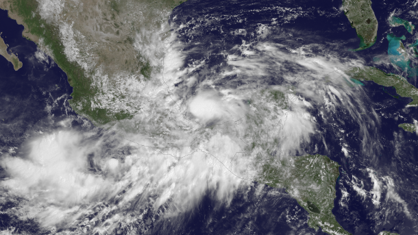
This image was taken by GOES East at 17:15 UTC on September 13, 2013.(Credit: NOAA/GOES/NNVL)
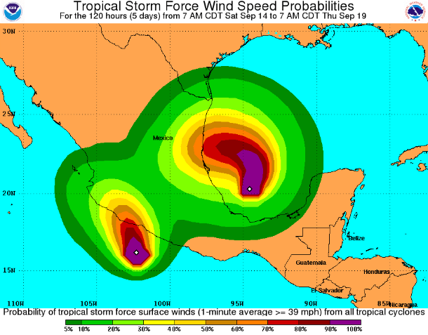
Tropical storm force wind speed probabilities map shows both tropical system (Credit: NOAA/NHC)
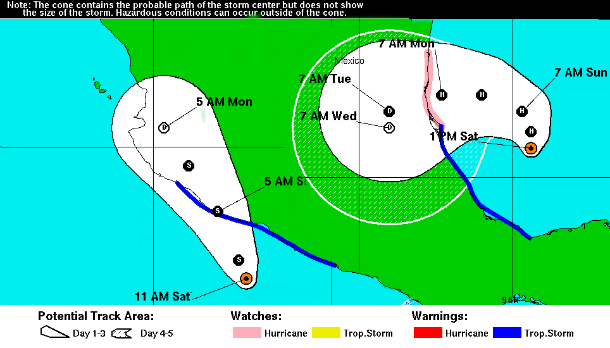
5-day forecast tracks of both systems (Credit: NOAA/NHC)
TS Manuel
According to latest public advisory issued by US National Hurricane Center (NHC) at 18:00 UTC on September 14, 2013, the center of TS Manuel was located about 105 miles (170 km) S of Lazaro Cardenas, Mexico and about 215 miles (345 km) SE of Manzanillo, Mexico.
The system is moving northward at speed of 6 mph (9 km/h). Maximum sustained winds are 50 mph (85 km/h) with higher gusts. Tropical storm force winds extend outward up to 70 miles (110 km) from the center. System's minimum central pressure is 994 mb (29.35 inches).
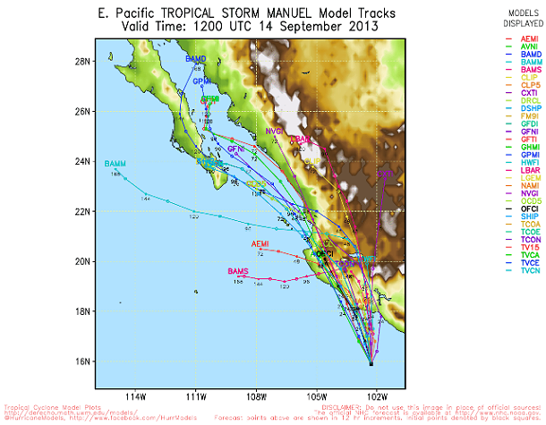
TS Manuel's forecast track models (Credit: UWM/Spaghetti)
Manuel is expected to produce 10 to 15 inches of rain over portions of the Mexican states of Oaxaca and Guerrero, with isolated maximum amounts of 25 inches possible. These rains are likely to result in life-threatening flash floods and mudslides, especially in mountainous terrain.
TS Manuel – Satellite Animations
- Storm-Centered Infrared (GOES 15; NOAA/SSD)
- Storm-Centered Infrared (Aviation Color Enhancement) (GOES 15; NOAA/SSD)
- Storm-Centered Water Vapor (GOES 15; NOAA/SSD)
- Storm-Centered Visible (GOES 15; NOAA/SSD)
- Storm-Centered Visible (Colorized) (GOES 15; NOAA/SSD)
- East Pacific Infrared (GOES 15; NOAA/SSD)
- East Pacific (Aviation Color Enhancement) (GOES 15; NOAA/SSD)
- East Pacific Water Vapor (GOES 15; NOAA/SSD)
- East Pacific Visible (GOES 15; NOAA/SSD)
- East Pacific Visible (Colorized) (GOES 15; NOAA/SSD)
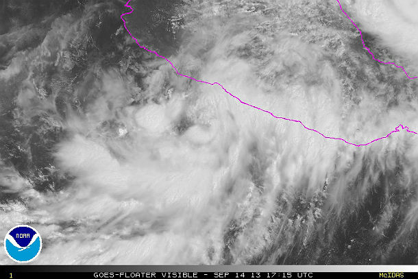
GOES floater visible satellite image of TS Manuel at 17:15 UTC on September 14, 2013 (Credit: NOAA/GOES)
TS Ingrid
According to latest public advisory issued by US National Hurricane Center (NHC) at 18:00 UTC on September 14, 2013, the center of TS Ingrid was located about 195 miles (310 km) E of Tuxpan, Mexico. The system is moving northward at speed of 8 mph (13 km/h). Maximum sustained winds are 70 mph (110 km/h). Tropical storm force winds extend outward up to 80 miles (130 km) from the center. System's minimum central pressure is 988 mb (29.18 inches).
.png)
TS Ingrid's forecast track models (Credit: UWM/Spaghetti)
A Hurricane Watch is in effect for area north of Cabo Rojo to La Pesca and a Tropical Storm Warning is in effect for Coatzacoalcos to Cabo Rojo. The NHC noted that Ingrid is expected to produce 10 to 15 inches of rain over a large part of eastern Mexico with isolated amounts of 25 inches possible, especially in areas of mountainous terrain.
TS Ingrid – Satellite Animations
- Storm-Centered Infrared (GOES 13; NOAA/SSD)
- Storm-Centered Infrared (Aviation Color Enhancement) (GOES 13; NOAA/SSD)
- Storm-Centered Water Vapor (GOES 13; NOAA/SSD)
- Storm-Centered Visible (GOES 13; NOAA/SSD)
- Storm-Centered Visible (Colorized) (GOES 13; NOAA/SSD)
- Gulf of Mexico Infrared (GOES 13; NOAA/SSD)
- Gulf of Mexico Infrared (Aviation Color Enhancement) (GOES 13; NOAA/SSD)
- Gulf of Mexico Water Vapor (GOES 13; NOAA/SSD)
- Gulf of Mexico Visible (GOES 13; NOAA/SSD)
- Gulf of Mexico Visible (Colorized) (GOES 13; NOAA/SSD)
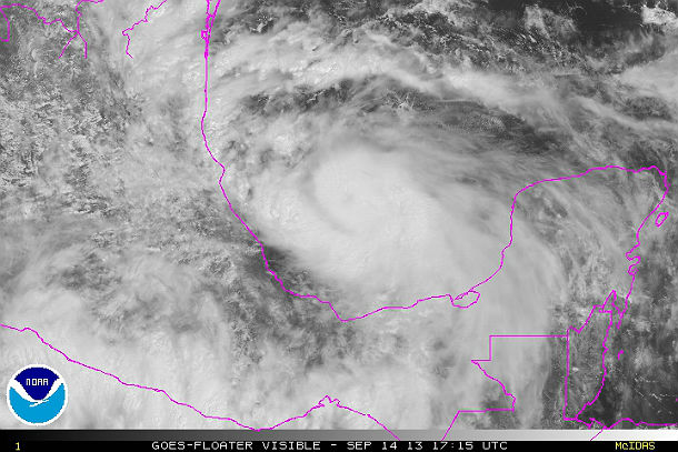
GOES Floater visible satellite image of TS Ingrid at 17:15 UTC on September 14, 2013 (Credit: NOAA/GOES)
Commenting rules and guidelines
We value the thoughts and opinions of our readers and welcome healthy discussions on our website. In order to maintain a respectful and positive community, we ask that all commenters follow these rules.