
Landsat captures images of activity at Nyamuragira volcano, Democratic Republic of the Congo

Featured image: False-color image of activity at Nyamuragira volcano on June 11, 2013. Credit: NASA Earth Observatory images by Jesse Allen and Robert Simmon, using Landsat 8 data from the USGS Global Visualization Viewer
During its flyby over Africa, on June 11, 2013, NASA's Landsat satellite captured some amazing images of Nyamuragira volcano, the Democratic Republic of the Congo. Nyamuragira is one of Africa's most active volcanoes.
Landsat observed the plume emitted from a pit inside the caldera that goes beyond Nyamuragira. Carbon dioxide, fluorine, and chlorine gas are found in Nyamuragira lava. Its plume is rich in water vapor which condenses rapidly in the humid tropical air, and also sulfur dioxide.
Landsat's sensors can pick heat in shortwave infrared light and heat can be detected as a red glow. Recent satellite images show no red glow above Nyamuragira, however, a red glow can be seen on nearby Nyiragongo volcano, which feeds a lava lake.
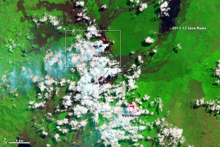
In false-color, clouds are mostly white and volcanic plumes are cyan. Forest and other vegetation is bright green. Fresh lava flows from the 2011–12 eruption of Nyamuragira are black, and older lava flows appear as brown tendrils running down the mountain’s flanks. Agricultural fields in the southeast (lower right) corner of the image also appear brown. Credit: NASA Earth Observatory images by Jesse Allen and Robert Simmon, using Landsat 8 data from the USGS Global Visualization Viewer.
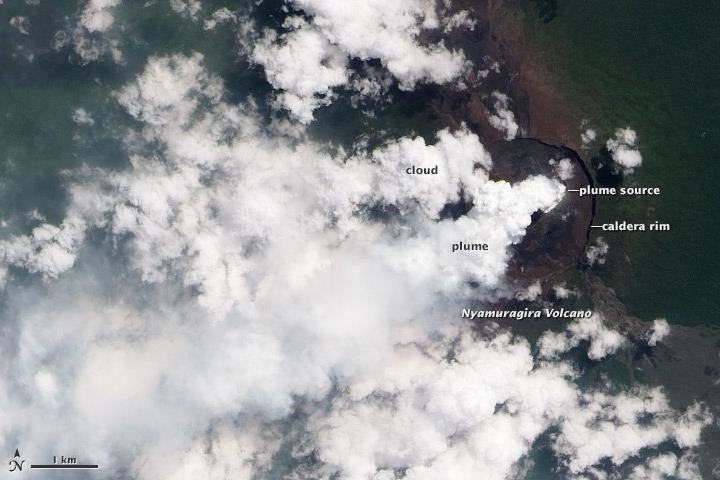
A thick plume rose from the summit of Nyamuragira volcano in June 2013. In natural color (top), the rainforest is dark green, clouds are white, and the sulfur-rich volcanic plume is very light blue. Barren land at Nyamuragira’s summit and lava flows are brown or black. Credit: NASA Earth Observatory images by Jesse Allen and Robert Simmon, using Landsat 8 data from the USGS Global Visualization Viewer.
Nyamuragira volcano, DR Congo
Goma, Lake Kivu, Nyiragongo, Nyamuragira and other nearby volcanoes sit within the East African Rift Valley, a zone where tectonic processes are cracking, stretching, and lowering the earth's crust. Volcanic activity is common here, and older but geologically recent lava flows (magenta in this depiction) are particularly apparent on the flanks of the Nyamuragira volcano.
Africa’s most active volcano, Nyamulagira is a massive high-potassium basaltic shield volcano that rises about 25 km north of Lake Kivu, NW of Nyiragongo volcano. Nyamuragira, also known as Nyamulagira, has a volume of 500 cu km, and extensive lava flows from the volcano blanket 1500 sq km of the western branch of the East African Rift.

Advanced Land Imager on NASA’s EO-1 satellite captured images on November 12, 2011.On November 6, 2011, after more than a year of relative peace, the Nyamuragira volcano in the Democratic Republic of Congo surged to life. Lava has erupted spectacularly from a fissure low on one of the volcano's flanks and spilled northward, away from populated areas. Nyamuragira is a shield volcano and one of Africa's most active. (NASA Earth Observatory image created by Jesse Allen, using EO-1 ALI data provided courtesy of the NASA EO-1 team.Caption by Mike Carlowicz.)
The 3058-m-high summit of Nyamuragira is truncated by a small 2 x 2.3 km caldera that has walls up to about 100 m high. Historical eruptions have occurred within the summit caldera, frequently modifying the morphology of the caldera floor, as well as from the numerous fissures and cinder cones on the volcano’s flanks. A lava lake in the summit crater, active since at least 1921, drained in 1938, at the time of a major flank eruption. Historical lava flows extend down the flanks more than 30 km from the summit, reaching as far as Lake Kivu. (GVP)
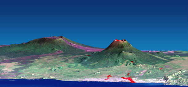
This computer-generated visualization combines a Landsat satellite image and an elevation model from the Shuttle Radar Topography Mission (SRTM) to provide a view of both the volcano and the city of Goma, looking slightly east of north. Additionally, image data from the Advanced Spaceborne Thermal Emission and Reflection Radiometer (ASTER) on NASA's Terra satellite were used to supply a partial map of the recent lava flows (red), including a complete mapping of their intrusion into Goma as of January 28, 2002. (Image Courtesy SRTM Team NASA/JPL/NIMA, Advanced Spaceborne Thermal Emission and Reflection Radiometer, and Landsat 7 Science Team)
Commenting rules and guidelines
We value the thoughts and opinions of our readers and welcome healthy discussions on our website. In order to maintain a respectful and positive community, we ask that all commenters follow these rules.